In the 1910s some Ozark hill counties had no more than two or three bridges eachSauer 1920, 224 (“There are few bridges, in some counties not more than two or three”); his fieldwork in the Ozark interior ran through the 1910s., and a geographer who traveled the interior then judged that bridge building “not rarely is the livest issue in the county politics.” On the upper Jacks Fork the point was proved in 1913, when backers of a site at the Harlow Crossing tried to stop the Texas County Court’s contract for a bridge at Buck Hollow, while Mountain View and Summersville raised moneyWehmer 2024, quoting the Mountain View Standard. for the roads that would lead to whichever site won.
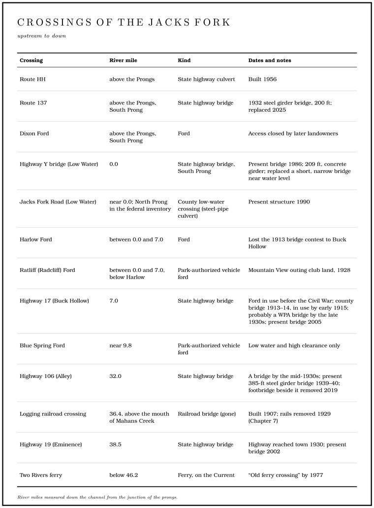
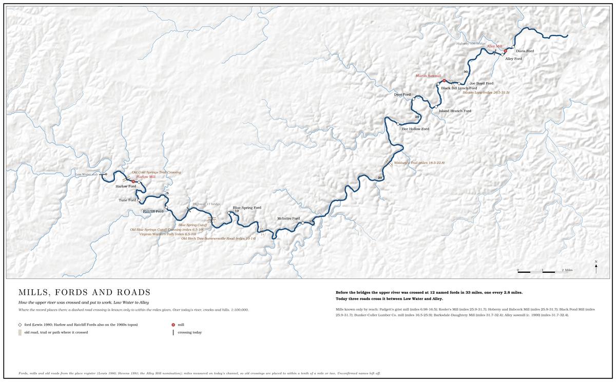
For most of its history the Jacks Fork was something the roads went down to, through and out of. People crossed it where the gravel let them, waited on the bank when it rose, and left their names on the crossings. Then the counties built a few bridges and the state took over the roads and numbered them (Map 8.1; each crossing has its own entryTable 8.1 and Part Five. in Part Five).
Fords
Before there were bridges there were Ford. A place where a road crosses through the water. Many of the river’s fords took the names of the families who lived beside them (Chapter 8). Glossary →, and a ford sat where the river allowed one. An Ozark stream runs as a string of Pool. A deep, slow stretch of river between riffles (Chapter 16). Glossary → joined by shallows. Below each pool the channel climbs over a bar of gravelthe pool-and-riffle form of an Ozark stream (general; see Chapter 15); Sauer 1920, 224, has the fords “located at broad shallows, formed by gravel bars,” quoted in Jacobson and Primm 1994, 36. laid across it, and there the water spreads out wide and thin and runs fast over a packed Bottom. The flat land along a river or creek, built of its deposits and open to its floods. In the 1920s the bottoms near Eminence averaged about a quarter of a mile wide (Chapter 2; Chapter 5). Glossary →. A team could pull a wagon across such a shallow where it would have foundered in the pool above or below. In the 1910s these bars were thought to be residual, left where Chert. A hard, fine-grained form of silica that forms in nodules and beds inside dolomite and stays behind when the dolomite dissolves. Most Ozark people call it flint. It makes up the river’s gravel and was the stone of the first people’s tools (Chapter 1; Chapter 3). Glossary → had weathered out of the ground rather than carried down by the river, and so unlikely to move. Many fords were thought to stay in one place for many years, and some to sit where the first settlers had crossedSauer 1920, 224 (the bars “probably residual rather than transported”; the fords “may remain at the same place for many years,” some “not changed appreciably since the first settlement of the region”); Jacobson and Primm 1994, 36.. Whether the gravel really stays still is a separate question (Chapter 15).
The main roads kept to the ridgetops. A ridge road drained well, never flooded and had easy Grade. The slope at which a river carries its load without cutting down or building up (Chapter 2). Glossary →, and the longest ridges needed the fewest valley crossingsSauer 1920, 223.. Under the thin upland soil lie, in most places, several feet of chert, the hard, flinty rock that is left behind in broken pieces when the Dolomite. Calcium magnesium carbonate rock, a close relative of limestone, formed from lime mud on the floor of a warm, shallow sea. Nearly every bluff on the Jacks Fork is dolomite (Chapter 1). Glossary → around it dissolvessee Chapter 1. (Chapter 1). Once a road was opened, wheels and hooves wore the soil away down to the chert, and the chert packed into what a geographer of the 1910s called “an excellent natural macadam.” Macadama road of compacted broken stone, named for the Scottish engineer John Loudon McAdam (general). is a road surface of broken stone rolled tight, and the packed chert behaved like one. Its slightly rough face gave a team good pulling, it drained well, and with very little care it held up under ordinary traffic, but its sharp edges wore out tires and horseshoes fast. On a hillside, though, a road with no ditches became the drain for the slope above it, and rain cut it into a gully, sometimes down to bedrock. Drivers then cleared a new track beside the old one, until in places a road ran between older, gullied tracks spread over a width of several hundred feet. New roads were made by felling trees just low enough for a wagon axle to clear the stumpsSauer 1920, 223., and travel did the restSauer 1920, 223–24 (the soil “underlain in most places by several feet of residual chert”; the roadbed “soon becomes a mass of well-packed chert”; hillside roads “gullied, in many cases down to bedrock,” until a road is “flanked by older, gullied roads to a width of several hundred feet”; “The improvement of the road is left to travel”)..
Where a road had to cross a valley, it came down a spur or a side hollow and struck straight across to the next ridge “within the shortest distance that the slopes of the valley permit,” so many fords probably sat near the mouths of side hollows. In the valleys a road commonly followed the Gravel bar. A bank of chert gravel and sand, usually on the inside of a bend, bare at low water (Chapter 15; Chapter 18). Glossary →Sauer 1920, 223 (“The road commonly follows gravel bars marginal to the stream or, if the stream is not large, even the stream bed itself”). along the stream, or the stream bed itself where the stream was small. After a freshet, the sudden rise that follows a heavy rain, the valley roads had to be cleared of drift and moved here and there “to avoid quicksands, undercut banks, and washed-out fords.” Along the Jacks Fork the valley road crossed to the far bank wherever the river swung against a Bluff. A cliff along the river, usually on the outside of a bend, where the river has cut sideways into the hill. In this sense the word was first used in North America (Chapter 2; Chapter 18). Glossary → and crossed back at the next bluff. Near Blue Spring the old road wound back and forth across the river by ford after fordNPS 1977, panel 1. (Reach D). Settlers sometimes laid low-water pole bridgesStevens 1991, 50, after Clendenen 1973., logs set across the bed to give hooves and wheels a firmer footing, and they paddled Johnboat. A long, narrow, flat-bottomed, square-ended boat, poled, paddled or motored. It was the guide boat of the Eminence outfitters and is still the fishing and gigging boat of the river. The word is in print from 1894 (Chapter 9; Chapter 18). Glossary → short distances to a neighbor’s, to the millBrown 1969, 46–47. or to the store.
The earliest routes in the Jacks Fork country followed the water to its crossings. By 1840 a road to St. Louis ran from the Chilton settlement on the Current down Blair Creek, crossing the Current at Owls BendStevens 1991, 49; see also the map “Central Shannon County Settlement Pattern 1840,” Stevens 1991, 36., a few miles below the mouth of the Jacks Fork. In February 1863 part of a Union army marched from West Plains to Pilot Knob by way of the junctionBrown 1969, 25. of the Jacks Fork and the Current, and that November a Union patrol came down the river to the mouth of Mahans Creek and turned up the creek on the road to ThomasvilleStevens 1991, 62; Brown 1969, 27. (Chapter 6). The hollows were the natural ways in and out of the river bottom, and the roads came down them.
On the lower river the old road to the mouth forded the Jacks Fork again and again. Until the county built the road that became Highway V in the 1930s, the only way between Eminence and the settlement at the mouth, then called Jack’s Fork, was “a long and arduous wagon road”Klinger and Kandare 1987, 39. that crossed “the river about six times.” Some of the traffic went by water instead. From 1913 a thirty-two-foot motorboat with a ten-horsepower engine, able to carry twenty-five passengers, ran regularly between Chilton, a railroad stop on the CurrentStevens 1991, 152., and Coot Bay at the mouth of the Jacks Fork. A post office called Jack’s Fork opened there by 1917 and lasted until 1954Klinger and Kandare 1987, 19, after Lewis 1980, 76–78..
Buck Hollow Ford
On the upper river the most important crossing was Buck Hollow Ford, where Highway 17 crosses today, about five miles north of Mountain ViewWehmer 2024 (“the new bridge five miles north of town”).. It was in use before the Civil War and shows on maps of the 1880s. It was the best place to cross between Mountain View and Summersville, on the north–south road that carried settlers and traders, and its rock bottom could be crossed most of the year. When the Current River Railroad was built east through Mountain View, on its way to the Grandin mill in 1888Pottenger 1945, Howell file (“Current River Railroad”); Stevens 1991, 76 (Grandin, late June 1888), 104; Brown 1969, 33, gives July 1, 1889; see Chapter 7. (Chapter 7), the road through the ford became the way to the depot for the country north of the river. Between Willow Springs and Grandin the railroad cut what had been a one- or two-week trip by wagon to a train ride of about four hoursStevens 1991, 104.. Freighters drove heavy wagons behind oxen or mules from Summersville down to the ford, across it and up the other side to the railroad. In dry seasons farmers drove cattle down to the river to drink, and on Sundays the ford was a Baptizing. A baptism by immersion in the river. Between 1885 and 1910 a baptizing in rural Missouri drew a neighborhood out much as a picnic did, and Buck Hollow Ford and Baptizing Hole were places for it (Chapter 19). Glossary →Wehmer 2024. place (Chapter 19).
Distance from the tracks was the great handicap of the hill country. Stations stood five miles or more apartSauer 1920, 222 (stations “on the average at least five miles apart”; in the hill districts the road distance “may be doubled”; areas “beyond the ten-mile line are seriously handicapped”; the remote sections served “by hack (stage) and freight service”)., and in the hills a road could run twice as far as a straight line between the same two points. A farmer there could make only one round trip a day with a loaded wagon. Beyond about ten miles from a railroad a farm was badly placed, and at twenty-five to forty-five miles it could hardly send its crops, and often not its timber either, to market at all. The back districts depended on the hack, a light wagon that carried passengers and mail, and on freight teams “operated on fairly regular schedule by professional teamsters.” A ford that let the teams through most of the year kept the country north of the river within reach of the depot.
The road carried passengers too. In a drought summer, probably 1934the book gives no year; see Chapter 9., the writer Ward Dorrance floated past the ford, which he spelled “Buck’s Holler,” and was told that a Stage. The height of the water surface above a gauge’s datum, the reading a gauge records. A stage differs from the depth of the water. At Eminence the datum stands 616.18 feet above sea level (Chapter 14). Glossary → line had come “down this rocky way,” leaving “the marks of its tires in the stone,” and that it had been “the route of a pony express.” Wagon-wheel scars could still be traced on rocks in the river at Buck Hollow in 1980Lewis 1980, PDF p. 19 (“At Buck Hollow there are traces of wagon wheel scars on rocks in the river”), the only source.. The Pony Express of 1860–61 ran far to the north and west, so that part is local legend. A mail hack or stage on the Mountain View–Summersville road is easy to believe.
When the river came up
A ford worked only when the river allowed it. When the Jacks Fork rose, the mail stoppedWehmer 2024., and so did supplies and news. The water can rise two feet in an hourThornberry-Ehrlich 2016, 36., because rain on steep hollows and thin, rocky soil runs off quicklygeneral; see Chapter 14. and reaches the river within a few hours (Chapter 14). A flood made the fords impassable for days and left them dangerous for a while afterward, until the gravel and sand had packed down againSauer 1920, 224 (the fords “usually impassable for a number of days in time of freshet and may be dangerous afterward, until the gravel and sand have again become compact”).. Fast water lifts gravel and sandgeneral. off the bottom and drops them loose, and wheels and hooves sank into the fresh deposits. The traveler who waited out the high water then had to clear the driftwood from the roadBrown 1969, 46; Sauer 1920, 223. before going on. Because the Jacks Fork is fed by springs, its flow does not swing widely except in spring floods, and those usually raise the river for a week or less, so most fords and ferries in the Current River country could be used the year roundBrown 1969, 47 n. 1 (“Because the river is spring-fed there are no wide fluctuations in its flow except for spring floods, which may cause the level to rise for a week or less. Thus, most fords and ferries are usable the year round”).. Nobody could schedule a rise, though, and a week without mail or a wagonload of goods stuck on the wrong bank cost a store or a farm real money.
The county seat felt every rise. In 1876 a stage line ran the forty-odd miles from Eminence to SalemStevens 1991, 70 (forty miles); Rader 2017, ch. 4 (“some forty-five miles”)., the Dent County seat and the nearest railroad, and in the 1880s it began running daily. The mail came twice a week in 1876, three times a week by the mid-1880sRader 2017, ch. 4. and every day by 1889Stevens 1991, 104 (three times a week by 1883); Rader 2017, ch. 4 (three days a week in 1885).. Even then the road out of Eminence was at times impassableRader 2017, ch. 4 (“the road from Eminence was at times simply impassable. Heavy rains and rising water on the Current and Jacks Fork Rivers could completely isolate Eminence—sometimes for days at a time”)., and heavy rains and rising water on the Current and the Jacks Fork could cut the town off, sometimes for days at a time. In June of 1873 or 1874, by one old resident’s account, rain fell for twenty-two days running. A gristmill on Mahans Creek kept the town in cornmeal and the deer hunters kept it in venison, “so we got along about as well as usual.”
The bridges did not end the waiting. A writer from ChicagoMarguerite Lyon, Take to the Hills (Lyon 1941). whose family took up a farm in Texas CountyLyon 1941, ch. 10. in the 1930s found that the trip out to the train could be stopped because “a bridge is out, heavy rains have flooded the ‘hollers,’ or the WPA workers have moved in on the road,” forcing detours of five to fifty milesLyon 1941, 51–52.. A neighbor girlLyon 1941, 150 (the chapter “Doris, Child of the Ozarks”). knew “to the drop how much rain must fall to flood Barn Holler to swimming depth; or to bring Jack’s Forks over the new WPA bridge.” The planners of the new roads, the writer thought, did not always remember that a little rain back in the hills could turn a trickle into a torrent “for anywhere from two hours to two weeks.” People said the bridge over the Jacks Fork, “sturdy and handsome though it is,” went under “if there is a heavy dew back in the hills,” though by her reckoning it took “a day and night of rainfall” to put it under water. On her own road the new grade at Barn Holler was built without even a culvert at a place where the neighbors went swimming after a rainy spell, and it had to be rebuilt the next summer.
Ferries
Where a river was too deep to ford, people built ferries, mostly on the larger Ozark streamsSauer 1920, 224., and they left only a thin record on the Jacks Fork. Few ferries ran anywhere in the Current River country before the Civil War. During the war Union troops forded the river in wagons near EminenceStevens 1991, 49–50., which suggests that no ferry was working there. In the 1920s people in the Current River country still got about by river ferryStevens 1991, 169. as well as by johnboat, wagon, railroad, car and truck. The best picture of a Jacks Fork ferry is a photograph from about 1910 in the Riverways’ collection, captioned “Family with a mule team and wagonStevens 1991, 173 (fig. 43), Ozark National Scenic Riverways collection. crossing Jacks Fork River on a ferry.” It shows a flat plank deck with plank rails, a team and wagon and several people standing on still water. The caption does not say where on the river it was taken (Fig. 8.1).
The ferries that ran on the Current into the 1950s show how a ferry worked in this country. At Powder MillHall 1969, 68 (a boat “of a kind unique to the mountain country, operating from a cable swung high across the stream and using the river itself for motive power”; the ferryman dropped “the stern end slightly downstream on each trip, upon which the force of the water pushes the craft across to its mooring on the opposite side”)., on the road from Ellington to Eminence, a traveler of the 1950s crossed on a boat that carried perhaps two cars and ran from “a cable swung high across the stream,” using “the river itself for motive power.” A boat of this kind hangs from the cable by a line at each end, and the lines run on pulleys along it. On each trip the ferryman let the stern drop “slightly downstream,” so that the hull lay at a slant to the current. Water pressing against the slanted side then pushed the boat sideways along the cable to its mooring on the far bank, and for the trip back the slant was reversedhow a current-driven cable ferry works (general)..
At Alley, by one account, a ferry worked from 1906 for several years, though where it crossed is not recordedLewis 1980, PDF p. 52, the only source; see Reach H. (Reach H). Another crossed the Current a short way down from the Two Rivers access, near the mouth of the Jacks Fork, where a Park Service folder of 1977 marked “an old ferry crossing.” The state’s float guide, in its edition revised in 1972, already sent floaters to take out there, three-quarters of a mile down the Current at the ferry landingHawksley 1965, 100 (the revised edition of 1972, the copy held: “Best take-out 0.75 mile downstream at ferry landing”)., and a map of 1980 names a Cooley FerryLewis 1980, PDF pp. 77 (map), 78; see Reach J. just below the meeting of the rivers (Reach J). At the Junction itself, a man who built his own boats kept a johnboat tied on each sideKlinger and Kandare 1987, 39. of the river as a ferry for the neighbors (Reach J).
The bridge fight of 1913
Bridges were hard to get because the districts of a county wanted different things. Some could reach a shipping point without crossing any troublesome stream, and people there usually voted against spending county money on bridges. Others were badly hampered without one. Where a bridge was needed, each possible site had its backers, who fought the backers of every other site, and often nothing was built at all. In Missouri the county court, today called the county commissionWehmer 2024., was the county’s governing board, a presiding judge and two associate judgesthe form of the Missouri county court (general). who ran its roads and spent its money, and a county court could stand or fall by its stand on bridgesSauer 1920, 224 (“In every county there are districts from which a shipping-point can be reached without crossing any troublesome stream. The residents of such localities usually oppose the appropriation of county funds for bridges”; “each location has its supporters, who in turn are antagonized by the partisans of other sites, with the not uncommon result that nothing is done”; “county courts stand or fall by their attitude toward this problem”)..
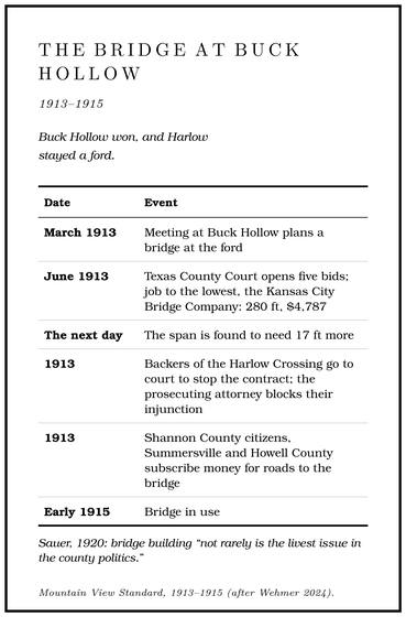
A bridge at Buck Hollow Ford was planned at a meeting there in March 1913. By June the Texas County Court at Houston had opened five bids and awarded the job to the lowest, the Kansas City Bridge Company, which would build a 280-foot bridge for $4,787, a little over $17 a footarithmetic from the contract figures.. The day after the award, the contractor and the county highway engineer drove out to Buck Hollow and found that the span would have to be seventeen feet longerWehmer 2024, after the Mountain View Standard, March 21 and June 1913. than the contract said.
Not everyone wanted the bridge at Buck Hollow. People who wanted it at the Harlow CrossingWehmer 2024, quoting the Standard., upstream, went to court to stop the contract, and the prosecuting attorney blocked their injunction. Money was being raised on both sides of the river for the roads that would lead to the bridge. Citizens of Shannon County and the town of Summersville contributed toward a good road from the river north to Summersville. In Howell County a subscription paper raised several hundred dollars for a road from Mountain View, and many of the townspeople, the Mountain View Standard reported, pledged “for a good road to either ford, according to where the bridge is erected.”
Buck Hollow won, and Harlow stayed a ford. The bridge went up quickly and was in use by early 1915Wehmer 2024 (“The project didn’t take long”). Lewis 1980, PDF p. 19, dates the steel bridge “about 1918”; the Standard‘s reports of 1913 and 1915 are followed here.. In February 1915 the Standard reported that Bill Smith, freighting for a Summersville firm, was crossing it when his lead mules took fright at the mail hack coming onto the far end of the span and whirled back toward the wagon, and one of his animals had to be put downWehmer 2024, quoting the Standard, February 12, 1915.. Freight wagons, the mail hack and an occasional automobile shared the bridge, though by one later account the span was so narrow that the freighters’ horses were afraid of it and the freight wagons avoided itLewis 1980, PDF p. 19 (“Freight wagons would not use the narrow bridge. The horses were afraid to cross the structure”), the only source; the Standard‘s report of February 1915 shows at least one freighter on the bridge, so the text softens “would not use” to “avoided.”, and by another it was hard on automobiles too. The bridge also opened the upper river to visitors. Buck Hollow gained a name as the first reliable year-round boat launchWehmer 2024. that far up the Jacks Fork, and by the early 1920s Camp WitbeckWehmer 2024, after a 1922 postcard and the 1922 Quill; NPS 2013 spells the family Whitbeck (Chapter 9). stood beside it (Chapter 9).
The bridge did not last. The Chicago writer’s farm lay in Texas County north of the river, and Mountain View, south of it, was her nearest townLyon 1941, chs. 8, 10., so the “new WPA bridge” on her road to town in the late 1930s was probably the Buck Hollow bridge’s replacement. The present Highway 17 bridge dates from 2005National Bridge Inventory.. Aerial photographs from 2006 and 2007 show a wide strip of bare ground along the highway at the crossing, and by 2012aerial photographs of 2006, 2007 and 2012, as traced for Fig. 21. the approach was paved and the strip had grown over (Fig. 21). A bridge’s piers and approach fillsgeneral; see Chapter 15. change the channel above and below it, narrowing the flow and changing where the river scours and where it drops its gravel. In 2001 two state highway projects were scheduled in the watershed, the replacement of the Highway 17 and Highway 19 bridges, both for 2001–2005MDC 2001, 83–84, 96.. What the work did to the swimming Hole. Any pool deep enough to swim or fish in, named or not, the basic unit of the river in local speech; also “hole of water” (Chapter 18). Glossary → at the bridge is taken up in Chapter 15.
Numbers on the roads
The bridge at Buck Hollow was a county project, paid for with county money and local subscriptions. Within a decade the roads were becoming the state’s business. The legislature had created a State Highway Department in 1913, though its one commissioner could do little more than advise the counties and urge them on, and the Hawes Road Law of 1917 created a four-member highway board so that Missouri could take federal road moneyMoDOT, “MoDOT History” (the 1917 law passed “so Missouri can receive federal funds”); MoDOT, “Commission Background” (the commissioner’s duties “largely advisory,” his main task “to encourage counties to make road improvements”; the 1917 law “provided for a bipartisan Highway Board of four members”).. In 1920 Missouri voters approved a $60 million bond issue to “get Missouri out of the mud.” The Centennial Road Law, signed on July 31, 1921Missouri Senate, “This Date in Missouri Senate History” (July 31, 1921, “considered to be the day the Centennial Road Law is signed”)., a hundred years after statehoodMissouri was admitted in 1821 (general)., created a state highway commission and laid out a state system of about 1,500 miles of primary roads and 6,000 miles of secondary onesMoDOT, “Commission Background” (“approximately 6,000 miles of secondary roads and 1,500 miles of primary roads”).. In 1924 voters added a two-cent taxMoDOT, “MoDOT History.” on each gallon of gasoline, so that the people driving the roads paid toward them, and in 1928 they voted $75 million more in road bonds. The drivers’ money paid the bonds off, and the last of them were retired in June 1957Official Manual 2007–2008, “Transportation” (bond issues of $60 million in 1920 and $75 million in 1928, repaid from highway-user revenues; all road bonds retired June 15, 1957).. Cars came quickly even to Shannon County. In 1921 the county had about forty-seven people for every motor vehicle, when the state as a whole had about ten and Dent County, with gentler ground and more trade, about twenty-fiveStevens 1991, 165–66 (persons per motor vehicle in 1921: Shannon County 46.70, Missouri 9.86, Dent County 25.50, where the terrain was “less dissected by steep ridges and the land supported greater commerce”).. By 1940 Shannon County had fewer than sevenStevens 1991, 169 (6.63 in 1940)..
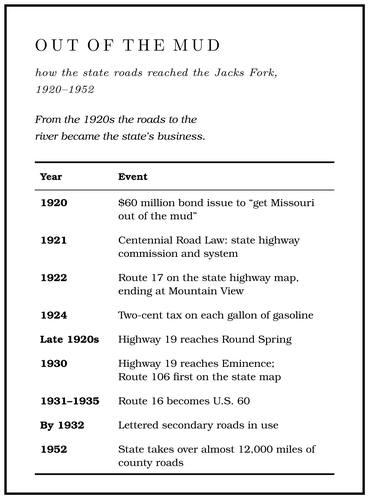
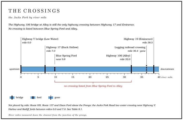
The numbered highways reached the river in the 1920s and 1930s. Route 17 appears on the state’s highway map from 1922, and at first it seems to have ended at Mountain ViewAARoads 2026, which gives the early terminus without citing a map; not yet confirmed on a map of the 1920s (The Open Ledger).AARoads 2026 (the years of the first official state highway map to show each route; the compilers warn that these are not always the years a route was created).. When the number first ran over Buck Hollow has not been established (The Open Ledger). Highway 19 reached Round Spring in the late 1920s and Eminence in 1930, and Route 16, the east–west road through Mountain View, became U.S. 60Stevens 1991, 169. between 1931 and 1935. Route 106, from Summersville to Eminence by way of Alley, first appears on the state map in 1930AARoads 2026 (first shown on the official state highway map of 1930).. The Chicago writer found the state highways of the late 1930s “excellent,” with plenty of hairpin curves, “for the roads largely follow the ridges,” as the wagon roads hadSauer 1920, 223., and the farm-to-market roads feeding them were being built mostly by WPA labor.
The crossing at Alley shows how the new roads replaced the old. A flood on the Jacks Fork in June 1928 destroyed the new store at Alley Spring State Park and, by one account, four bridges in the parkStevens 1991, 182 (“destroyed the new store and four bridges at Alley Spring State Park”).; by another, those bridges, built across the Spring branch. The stream that runs from a spring to the river, such as the branch below Alley Spring (Reach H). Glossary →, went out in a flood in the spring of 1927Perry [1978], sec. 8, 2 (“four bridges that had been recently built across the spring branch”); see Chapter 14 and Reach H. (Chapter 14). By the mid-1930s a bridge crossed the river at Alley, and Dorrance’s party floated beneath itDorrance 1938, 34.. In 1939–40 the state built the present Highway 106 bridge, a steel girder bridge about 385 feetNRHP, Alley Spring 2023, 12; National Bridge Inventory. long on concrete piers, still the only highway crossing between Highway 17 and Eminence. The highway it carried was paved in the mid-1950sNRHP, Alley Spring 2023, sec. 7, 7 (the road “extended to the west and paved in the mid-1950s”; the bridge is MoDOT bridge no. K0924, sec. 7, 12).. By 2026 its federal inspection rated it in poor conditionNational Bridge Inventory., the lowest of the three gradesthe Federal Highway Administration’s good, fair and poor classification (general). given to the nation’s bridges. A footbridge beside it, damaged in the April 2017 flood and again in February 2018, was closed, and the river beneath it was closed to floaters as unsafe. Early in 2019 the Park Service took the footbridge down and at first promised only to look for other ways for walkers to crossNPS 2018; NPS 2019. there. That April, when the river under the site was opened again, it said that it and the Federal Highway Administration meant to build a new footbridge with federal emergency-relief money for damaged roads on federal land, and it gave no dateNPS 2019 (river reopened) (the pedestrian bridge “completely removed” with the Federal Highway Administration, and a new one planned under the Emergency Relief for Federally Owned Roads program, with no completion date). (Chapter 14).
The lettered roads came next. In 1952 the state highway department took over almost 12,000 miles of county roads and gave them letters, and by its own reckoning the takeover put 95 percent of Missourians within two miles of a hard-surfaced roadMoDOT, “MoDOT History” (the department took over “almost 12,000 miles of county highways,” bringing “95 percent of all Missourians” within “two miles of a hard-surfaced road”).. The letters, single ones and doubled ones such as OO and HH, are used over again from county to countySoutheast Missourian 2014 (the Takeover Program of 1952; single- and double-letter routes; the same letter used in different counties); MoDOT, “Commission Background” (the Takeover Program’s goal of 12,000 miles)., so a lettered road is known by its county as well as its letter. Around the Jacks Fork the letters are the roads people still use to reach the water: Y goes to the Prongs, O to Bluff View, OO to Blue SpringMDC, Jacks Fork Natural Area. and V to Two Rivers. The road to Two Rivers began as a county road across land the Russell family gave, and the WPA graveled itKlinger and Kandare 1987, 38–39..
Even then the river stayed hard to cross. By 1969 only two road bridges crossed the Jacks Fork inside the new national riverways, and no major road or trail had ever crossed either the Current or the Jacks Fork. The roads that reached the rivers were local roads, used by the people who lived along them for their daily businessBrown 1969, 48 (“Historically, no major roads or trails passed over the Current or Jacks Fork; rather they were local roads used by the residents in their daily tasks”)., and they went around the rivers or down to them and back out. At Eminence the town’s first bridge, by one account a narrow steel bridge, was finished in March 1917, and a concrete bridge for the new Highway 19 replaced it in 1934–35Lewis 1980, PDF p. 69 (work begun December 1916 by the Canton Bridge Company, with $3,000 from local people matched by the county court; the concrete bridge begun February 1934 and finished 1935), the only source; see Reach J. (Reach J). That bridge in turn was replaced in 2002National Bridge Inventory.. Families across the riverways in the 1990s often brought out photographs of old bridges, among them one of a rope bridge over the Jacks Fork near EminenceGibson 2000, 48 (“the infamous rope bridge near Eminence over the Jacks Fork,” among the photographs families showed her in the 1990s), the only source., probably a footbridge, whose builder and dates have not been recorded.
Low water
A Low-water bridge, low-water crossing. A road crossing built low across a stream, a ford with a floor, often a concrete slab with culvert pipes beneath it, which water overtops in a rise (Chapter 8; Chapter 18). Glossary → sits right at river level, and it amounts to a ford with a floor. Its deck lies about as high as the river’s ordinary flow, and pipes or openings under it carry the river through in normal times. When the river rises past what the pipes can take, it runs over the top, and the crossing is built to stand that. A low crossing needs no long approaches or tall piers, so it costs far less than a high bridge, and the price is that it goes under with every good risehow a low-water crossing works (general).. The settlers’ pole bridges were the first version. On the Black River, east of the Current, a few days before, Dorrance met another, “rough hewn logs set flush with the current,” which his party had to drag their boat around. The automobile brought concrete. An undated photograph in the Riverways’ collection shows a Model T crossing the Jacks Fork near Alley on a low-water slab, with water sheeting across the deck around its wheels (Fig. 8.2). Another, from about 1925, shows a team and wagonStevens 1991, 174–75 (figs. 44–45), Betty Hicock Collection, Ozark National Scenic Riverways. fording the river near Alley. Neither crossing has been located.
At the head of the river the name stuck. Most people who grew up there use Low Water for the Highway Y bridge and the accessJacks Fork Oral History, records SV-03, SV-06, SV-20. beside it, and some call the junction of the Prong. A branch or arm of a creek, set down in 1860 as Southern usage. The North and South Prongs join to form the Jacks Fork (Chapter 18). Glossary → itselfJacks Fork Oral History, record SV-22; others call the junction the Forks, the Prongs or Jammed Up. Low Water. The local name for the Highway Y bridge over the South Prong, the access beside it and the county’s low-water crossing where the prongs meet, and so for the head of the river (Chapter 8; Chapter 18). Glossary →. The name is said to have come from a bridge. A Mountain View resident remembered that the old Highway Y bridge over the South Prong, before the present one was built, “was really a very short bridge, not much higher than the water level frequently, and not really wide enough for cars to meet on it.” The state’s float guide, first published in 1965 and revised in 1972, began its count of river miles at the Prongs and the Highway Y low-water bridgeHawksley 1965, 98 (the Jacks Fork mile list opens at 0.0 with the Prongs and the Highway Y low-water bridge; the 1972 revision cannot be told from the 1965 text in the copy held); the same table, with later access notes, is reprinted as MDC 2003.. The present Highway Y bridge, built in 1986, is a 209-footNational Bridge Inventory (structure 3647). concrete girder bridge standing well above the water. A few hundred yards away Jacks Fork Road crosses on a county Low-water bridge, low-water crossing. A road crossing built low across a stream, a ford with a floor, often a concrete slab with culvert pipes beneath it, which water overtops in a rise (Chapter 8; Chapter 18). Glossary → built in 1990, set right where the prongs meet. Each prong runs under the road through three steel culvert pipes, and the Jacks Fork leaves the downstream side through all six, at mile 0. An older low-water bridge on the same road was washed out again and againLewis 1980, PDF p. 11 (“A low water bridge crosses at the Forks. The creek has repeatedly washed the bridge out. The road comes from Highway W at Arroll and goes into Highway Y”), the only source; his map (PDF p. 12) letters “Low Water Bridge” at the Forks., and in June 1957 a canoeist putting in at the Forks, the. The North and South Prongs and their junction, where the Jacks Fork begins; also called the Prongs (Chapter 18). Glossary → found the gravel road reaching the stream “at a little low-water bridge”Hall 1969, 72; see Chapter 9. Which bridge Hall meant is not stated. (Chapter 9). Nobody has yet established when the old Highway Y bridgethe National Bridge Inventory lists only the present structure (3647, 1986). was built (The Open Ledger). People at the Prongs call the county crossing the low-water bridgeJacks Fork Oral History, record SV-05. or the low-water crossing, and floaters put in just below itfield observation, 2026; aerial imagery of the Jacks Fork Road (County Road 4670) crossing. (Fig. 15; Plate A3). The same resident recalled that the new Highway Y bridge “changed the river and the swimming hole quite a bit”Jacks Fork Oral History, record SV-20, the only account of the name’s origin. (Chapter 15). How the crossings got their local names is taken up in Chapter 18.
A slab is convenient in summer and a hazard the rest of the year. Water pours through the pipes and over the deck, drift catches on it, and a floater who meets one has to get out and carry around (Part Six). For a driver the danger is greater. Most people killed by floods in Missouri are in vehicles, twenty-three of the twenty-seven who died in the state’s floods of 2015, and two feet of moving waterSEMA, flood safety (“23 of the 27 people” who died in Missouri flooding in 2015 were in motor vehicles; “two feet of rushing water” can sweep most vehicles away). is enough to carry most cars and trucks off a road. Above the Prongs, Route 137 crossed the South Prong on a one-lane steel girder bridge of 1932, twenty-one feet wide, until the state, having rated it structurally deficientNational Bridge Inventory (structure 8749: built 1932, steel stringer, one lane, 6.4 m wide and 61 m long; deck rated poor)., closed the road between Routes U and AZ on July 21, 2025, to replace it, with the work expected to run into the middle of OctoberMoDOT 2025 (work to begin July 21, completion expected October 17); MoDOT 2024 (the replacement scheduled for 2025). Whether the new bridge opened on time has not been confirmed.. That Rating. The curve that gives a river’s flow for each stage at a gauge, built from measurements across the channel and redrawn as moving gravel shifts the channel (Chapter 14). Glossary → means that inspectors have found the deck, the beams or the piers and abutments in poor condition, though the bridge may still be safe to usethe Federal Highway Administration’s definition, a bridge with its deck, superstructure, substructure or culvert rated poor or worse (general).. Other county roads cross both prongs on culvertsNational Bridge Inventory (Route HH, structure 6857). and slabs (Table 8.1). One person remembered friends camping at Pebble Dam on the North Prong who were nearly swept away by a Flash flood. A sudden, fast rise of water after heavy rain, fed by quick runoff from steep slopes (Chapter 14). Glossary → and lost both their vehiclesJacks Fork Oral History, record SV-05. to it.
Fords still in use
Some of the old fords are still driven. Only four vehicle fords are authorized in the whole park, and two of them are on the upper Jacks Fork: Ratliff Ford, above Highway 17, and Blue Spring FordNPS 2022a, 19, map 10 (“The authorized vehicle fords are Akers Ford, Banks Ford, Ratliff Ford, and Blue Spring Ford”); NPS 2024.. Blue Spring Ford is still driven at low water by high-clearance vehicles (Reach D), and the park’s designated fords are listed in Part Six. Harlow Ford shows on the 1948 topographic mapUSGS 1948 (Summersville)., and a Mountain View resident who knows the upper river was not sure the road still reaches itJacks Fork Oral History, record SV-20.. Someone who knew the river around Alley remembered that “at one time we could ford the riverJacks Fork Oral History, record SV-15. in a few places above Alley, and below the spring.”
Vehicles and horses still reach the river in other ways. More than thirty-nine miles of undesignated roads and traces have been mapped in the park, most of them made by off-road driving, and undesignated stream crossings are counted among the threats to water quality and to the Ozark Hellbender. A giant salamander up to nearly two feet long, flat and mottled brown, that needs cold, clean, flowing water. The Ozark hellbender was described from a Current River specimen in 1943, and by 2019 the Jacks Fork was thought to hold ten or fewer (Chapter 16). Glossary →, a giant salamander that nests under flat rocksNPS 2022a, 61. in the riverbed (Chapter 16). Wheels and hooves in a Riffle. A fast, shallow, rocky stretch between pools. The riffles are the gardens of the riverbed: in July a square meter of riffle produced more than six times as much as a square meter of pool (Chapter 16). Glossary → loosen siltgeneral; see Chapter 16. and fine gravel, and the current carries them down into the spaces under the rocks. The park has seven designated horse-trail crossingsNPS 2022a, 3–5, 13–15, 19 (staff “have documented over 39 miles of undesignated, visitor-created roads and traces”; undesignated crossings “can have an adverse impact on water quality and the Ozark hellbender”)., and below Eminence the big Trail ride. An organized gathering of hundreds or thousands of horseback riders, camping for several days and riding the trails and river crossings. The trail rides grew into a large business on the lower Jacks Fork (Chapter 11). Glossary → take riders across the Jacks Fork by the hundreds (Chapters 10 and 17).
Family names at the fords
On a map of the upper river the fords carry family names: Harlow Ford, Radcliff Ford (now Ratliff), McIntyre (McIntire) Ford, where the old road from Birch Tree to Summersville came down Lost Hollow to the river (Reach E), Lodder FordJacobson and Primm 1994, 56 (an oral history, as “Loader Ford”)., and DixonUSGS 1948 (Summersville; Harlow Ford; “McIntyre Ford”); Lewis 1980, PDF p. 30 (McIntire Ford, the old road from Birch Tree to Summersville down Lost Hollow); Jacobson and Primm 1994, 56; Jacks Fork Oral History, record SV-20. FordJacks Fork Oral History, record SV-20 (marked on a map), measured on the South Prong’s traced channel; see Reach B. on the South Prong. Landings follow the same pattern at Rymers and BachersMDC 2003; NPS 2022a, map 10 (“Bacher Landing”).. The bridges carry highway numbers, Y, 17, 106 and 19, and the few exceptions take their names from a feature of the land, such as Buck Hollow.
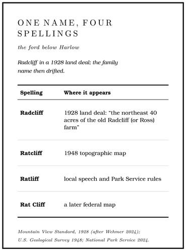
A ford stayed in one place for generations at a stable gravel shallow, and the road down to it usually ran through somebody’s farm. The clearest case is a land deal of 1928. A group of Mountain View business and professional men bought river frontage near Buck Hollow for an outing club: the Craig farm of 160 acres, through which the river ran for about three-quarters of a mile below the ford, and “the northeast 40 acres of the old Radcliff (or Ross) farm,” with another quarter mile of river, which “includes part of the road and the ford.” The purchase gave the club about a mile of the river, and the Standard called the crossing “the closest ford to Mountain View.” By the spring of 1929Wehmer 2024, quoting the Standard, October 10, 1928 (the purchase “giving control of about a mile of the best fishing water on Jack’s Fork”), and April 5, 1929. club members were donating their labor on the road down to it. The family name then drifted. Radcliff became RatcliffUSGS 1948 (Summersville); USGS GNIS. on the 1948 topographic map and Ratliff in local speech and in Park Service rules, and a later federal map printed it as Rat CliffWhitaker 2025; NPS 2024.. Harlow Ford probably takes its name from a family as well. A Texas County school near Mountain View was named for Reuben HarlowO’Brien 1939, Texas County, 57., one of the county’s earliest settlers, and Greenberry Harlow, said to be his son, is credited with a mill at the ford after the Civil War and kept a Harlow’s Mill post office in 1875 and 1876Lewis 1980, PDF pp. 9, 14; Rowe 2008 (Harlow’s Mills, Greensberry Harlow, February 25, 1875, to February 7, 1876); see Reach C. (Reach C). Dixon Ford was “always called Dixon Ford or Dixon Crossing,” in the words of a Mountain View resident, and it “used to be a great place to hang out at the river” until new owners closed it to visitors. Who Dixon, Lodder and Bacher were has not been traced (The Open Ledger).