On a spring float written up in the April 2013Dufur 2013, 18–19 (Brett Dufur). The float date is not given; it was a spring float before the April 2013 issue, probably in 2012. issue of the state’s conservation magazine, a writer put in at Buck Hollow and passed Blue Spring, where “the spring feeds an excellent swimming Hole. Any pool deep enough to swim or fish in, named or not, the basic unit of the river in local speech; also “hole of water” (Chapter 18). Glossary →.” Aerial photographs of the bend tell the same story for the years around his float. In 1995 a broad, dark Pool. A deep, slow stretch of river between riffles (Chapter 16). Glossary → lay along the outer bank below the spring, beside a big rock that swimmers used for jumpingsee Reach D (Fig. 16)., and the bars on the inside of the bend were small. The pool had much the same outline in 2009, 2012 and 2014. In the photographs of 2020 the inside of the bend is a sheet of sand and gravel, and the pool has become a narrow channelFig. 22, traced from dated aerial imagery, 1995–2026. squeezed against the rock and the Bluff. A cliff along the river, usually on the outside of a bend, where the river has cut sideways into the hill. In this sense the word was first used in North America (Chapter 2; Chapter 18). Glossary → (Fig. 22).
Nearly three milesReach D (legacy miles 6.8 and 9.6; measured miles 6.98 and 9.79). upstream, at the Highway 17 bridge, two people who swam there in the 1970s and 1980s remember the deepest water at the bridge and along the bluff, with a Gravel bar. A bank of chert gravel and sand, usually on the inside of a bend, bare at low water (Chapter 15; Chapter 18). Glossary → to go in from and places to jump from the bluffJacks Fork Oral History, records SV-06 and SV-20.. The photographs there show a narrow river with thin bars through 2012, a new bridge built in the middle 2000s, and bars spreading at the access and beside the bridge by 2020Fig. 21. (Fig. 21).
A swimming hole is a temporary arrangement of gravel, and the Jacks Fork has rearranged its holes for as long as it has carried gravel. What happened at these two holes can be set against what is known of the river’s gravel, how much of it there is, where it came from, how it moves and what people have done to it.
Shoals and pot-holes
Any mile of the Jacks Fork repeats a pattern. A short stretch of quick, shallow water runs over gravel. Below it the river slows and deepens into a long pool, often under a bluff, and beside the pool, usually on the side away from the bluff, lies a bank of bare gravel. Then the river shallows and quickens again (Fig. 15.1). Geologists call the three parts the Riffle. A fast, shallow, rocky stretch between pools. The riffles are the gardens of the riverbed: in July a square meter of riffle produced more than six times as much as a square meter of pool (Chapter 16). Glossary →, the pool and the bar. A geographer who studied the Ozarks a century agoSauer 1920, quoted in Martin 2005, 23–24. described its streams as “a rapid succession of riffles and pools, with the pools flanked by wide white ‘gravel bars.’” On the upper Jacks Fork in a drought summer, probably 1934, people told a writer floating the river that its course was “Shoal. A fast, shallow, rocky stretch between pools; a riffle. Suckers crowd onto the shoals in spring, and the old saying is that “the dogwoods bloom when the suckers are shoaling” (Chapter 18; Chapter 19). Glossary → and Pot-hole. A 1930s word for a still pool under a bluff, between shoals (Chapter 18). Glossary →, jest shoals and pot-holes,” the pot-hole being the still pool under a bluffDorrance 1938, 26; for the year of the float, see Chapter 9..
Each part has its own work. The riffle is a step in the river’s long profile, where the water drops over a sill of gravel. Riffles tend to form at the crossingsgeneral river geomorphology; see Chapter 2., where the main current swings from the outside of one bend over toward the outside of the next and spreads thin across the gravel between them. The pool forms where the current is thrown against something it cannot easily move, most often the bluff on the outside of a bendsee Chapter 2., and scours a hole at its foot (Chapter 2). These are the holes people swim in and fish in, and they hold the deepest water in a dry August. The bar builds on the inside of the bend, where the current slackens and drops the gravel it was carrying, and over the years it grows out toward the pool.
On an ordinary summer day the river hardly moves its bed. A stone on the Bottom. The flat land along a river or creek, built of its deposits and open to its floods. In the 1920s the bottoms near Eminence averaged about a quarter of a mile wide (Chapter 2; Chapter 5). Glossary → stays where it is until the water pushes on it hard enough to roll it or lift it, and on the Jacks Fork that takes a rise. In a flood the bed itself goes into motion, stones rolling and skipping along the bottom by the thousands, a load the river carries on its floor rather than in its watergeneral; on the threshold of motion (“critical shear stresses that must be exceeded to transport sediment”), Jacobson, Femmer and McKenney 2001, 9., and when the water falls they drop where the current slackens. Gravel comes off one bar, rolls downstream and lodges on another, and a pool fills a little in one flood and may be dug out in the next. The pattern of riffle, pool and bar lasts while the gravel in it is replaced, which is why a Ford. A place where a road crosses through the water. Many of the river’s fords took the names of the families who lived beside them (Chapter 8). Glossary → at a riffle could stay in one place for generationssee Chapter 8. (Chapter 8) and a particular hole could not.
Where the gravel came from
The gravel of the Jacks Fork is Chert. A hard, fine-grained form of silica that forms in nodules and beds inside dolomite and stays behind when the dolomite dissolves. Most Ozark people call it flint. It makes up the river’s gravel and was the stone of the first people’s tools (Chapter 1; Chapter 3). Glossary →. As the Dolomite. Calcium magnesium carbonate rock, a close relative of limestone, formed from lime mud on the floor of a warm, shallow sea. Nearly every bluff on the Jacks Fork is dolomite (Chapter 1). Glossary → of the uplands dissolved over millions of years, the chert in it was left behind as a mantle of broken rock in red clay, and that mantle is the river’s supply (Chapters 1 and 2). Chert does not dissolvesee Chapters 1 and 2. and wears down only slowly, so the pieces last through mile after mile of rolling. The geographer who described the Ozark riffles and pools judged it, apart perhaps from Porphyry. The old Missouri name for rhyolite, from the scattered crystals in its fine-grained body (Chapter 1). Glossary →, “the most durable material in the Ozarks.” Most of it breaks into flattened pieces with curved, shell-like faces, a shape the current moves with difficulty, and on the floor of a typical Ozark stream he found the fragments “little smaller and little less angular than the chert on the hillsides.” A gravelly bed of that kind resists the water better than the banks beside it do, so the stream works sideways, and he saw beds spread to as much as twenty times the width of the water at ordinary Stage. The height of the water surface above a gauge’s datum, the reading a gauge records. A stage differs from the depth of the water. At Eminence the datum stands 616.18 feet above sea level (Chapter 14). Glossary →. Water also moves freely between the stones. A creek that looks dry may have water running under its bed, and “shallow pits dug in the bed of a creek usually fill with water in a short time” (Chapter 14). The river has always carried gravel. The question is how much, and since when.
In the early 1990s the federal hydrologist and the oral historian whose interviews appear in Chapter 14 chose the Jacks Fork as one of two Ozark basins in which to trace the history of land use and the river’s gravel. The Eminence Gauge. A station of the Geological Survey that records the river’s stage, from which its flow is figured. The Jacks Fork has gauges at Highway 17, Alley and Eminence (Chapter 14). Glossary →, with its record from 1921, was one reason. They compared land surveys of the 1830s, census returns, old photographs and aerial photographs from 1938 on, and they interviewed older residents in their homesJacobson and Primm 1994, 1–2, 4, 10–12 (Robert B. Jacobson, U.S. Geological Survey, and Alexander T. Primm, Oral History of the Ozarks Project)..
Early descriptions of Ozark streams say little about gravel bars. An 1877 descriptionWilliams 1877, quoted in Jacobson and Primm 1994, 34. called the Current, the Jacks Fork and the Barren Fork “rapid-flowing and clean, with narrow fertile valleys.” Early travelers rarely described gravel bars, while geologists of the later 1800s found large quantities of gravel in the banks and beds. In 1855 the state’s first geological surveySwallow 1855, 66, 169, as quoted in Jacobson and Primm 1997, 14. reported that “many of our streams abound in water-worn pebbles, which constitute their beds, and form bars along their margins and channels,” and counted the pebbles a resource, valuable “for roads and streets.” The streams had probably always held gravel, then, but had not always been so unstable. They had gone through unstable spells before settlement as well. Old layers of gravel and soil in Ozark stream banks, dated by radiocarbon, record earlier episodes in which channels filled with sediment and shifted, but the episode that followed settlement moved much more gravel and sandJacobson and Primm 1997, 2–5 (after Jacobson and Pugh 1992: “pre-settlement period episodes of stream aggradation and instability”; the post-settlement episode “involved much greater volumes of gravel and sand than the previous episodes”). than any of them. Before settlement they carried a mixed loadJacobson and Primm 1994, 1 (“a mixed sediment load of gravel bedload and silty overbank sediment”)., gravel rolling along the bed and silt spread over the bottoms in floods, and the deposits left on old Floodplain. The flat valley floor that a river builds and floods (Chapter 2). Glossary → suggest that the channels were generally narrower and deeperJacobson, Femmer and McKenney 2001, 33 (“presettlement streams generally were narrower and deeper”). than they are now.
The change came in stages tied to land use. Settlers cleared the narrow valley floors for fields and pasture. The timber boom of about 1880 to 1920 (Chapter 7) brought roads along the creeks and across the bars and more clearing in the bottoms. Regional floods in 1895, 1897, 1904 and 1915 struck valleys that had lost much of their streamside timber (Chapter 14). Ozark floods of that timeSauer 1920, 51 (a general description of Ozark floods, following his account of the floods of 1914 and 1915)., as the geographer described them, undercut the banks, uprooted trees, tore down fences, carried off haystacks and shocks of grain, and left the fields “overspread with gravel and driftwood.” From about 1920 to 1960 the woods were burned each spring and grazed by stock on Open range. The old rule that a farmer fenced his crops in and let his animals run on all unfenced land; also called free range. Shannon County kept it the longest in Missouri, until a state law of 1969 (Chapter 5). Glossary → (Chapter 5), and the cattle and hogs gathered along the streams and ate the young trees off the bars. By models of how land use governs runoff and erosion, that period should have been the most damagingJacobson and Primm 1994, 1–2, 85 (“Models for land-use controls on annual runoff, storm runoff, and soil erosion indicate this period should have been the most effective in creating stream disturbance”)., and grazing along the streams was probably the most direct and damaging linkJacobson, Femmer and McKenney 2001, 32 (“probably the most direct and damaging land-use link to stream instability”). between land use and unstable streams. Floating the Black RiverDorrance 1938, 9–10., the next big river to the east, in the mid-1930s, a writer found the number of hogs at large “incredible”: “At every bend in the stream there stands haunch-deep a band of shoats, grubbing for shell-fish.”
By the mid-1940s it was popularly acceptedJacobson and Primm 1997, 33 (after Bauman 1944). that the filling and instability of the streams came from changes in how the uplands were used, and in 1958 a writer and conservationistLeonard Hall, Stars Upstream (1958), 43, 50, as quoted in Jacobson and Primm 1997, 33; see Hall 1969 and Chapter 10. who knew the Current country well (Chapter 10) put the common view in print: “The thin topsoil washed away down the hollows until there was little left but rocky chert, and the mountain streams became choked with gravel.” Fewer game fish, he wrote, “grew in gravel-choked streams.”
Most of the new gravel probably came out of the small valleys and the valley bottoms, where gravel storedJacobson and Primm 1994, 87. under soil and trees was cut loose once clearing and floods opened new channels into it. With the timber gone from their banks, the channels of the small hollows could cut headward, working upstream into ground that had been stable, and the cutting would have released stored gravelJacobson and Primm 1994, 1 (their hypothesis: “headward migration of channels, resulting in extension of the drainage network and accelerated release of gravel from storage in the small valleys”). downstream. A man who had roamed the Big Piney and Jacks Fork basinsJacobson and Primm 1994, 39 (table 6), 57. all his life put it plainly: “The gravel was there but it had dirt on it. But the dirt gets washed off of it and then it washed the gravel out.” A man born on an upper-river farm in 1904Jacobson and Primm 1994, 39 (table 6), 58. said the gravel “was already in the river. It just washed in the deep holes.” The upper Jacks Fork was never used for floating ties, yet its channel was disturbed anyway, so Tie drive. Floating loose ties down a river in a mass. Missouri limited loose drives to 50,000 ties in 1909 and in 1919 required that all ties be rafted, laid crosswise and fastened together (Chapter 7). Glossary → were not neededJacobson and Primm 1994, 86. to fill a river with gravel.
A wave of gravel
Gravel set loose in the side valleys reaches the river and moves down it in pulses, flood by flood, piling up in some reaches while others drain. Geologists call such a pulse a wave. A gauge keeps a record of the riverbed as well as the water, because every time a crew measures the flow it measures the depth across the channel, and from those soundings the average height of the bedthe mean streambed elevation computed from gauge measurements (Jacobson 1995, as described in Martin 2005, 13). can be worked out year by year. At the Eminence gauge the average level of the riverbed rose quickly around 1940 and then fell steadilyMartin 2005, 13, after Jacobson 1995. for the next half century, probably the trailing edge of a wave of land-use gravel that had started down the river before the gauge was builtJacobson and Primm 1994, 88 (“the recessional limb of a passing wave of land-use-induced sediment that began before gage construction”).. The building of a bridge at the gauge siteJacobson and Primm 1994, 5 (fig. 3). disturbed the bed there as well. Read over the longer span from 1921 to 1990, beside three other Ozark gauges, the bed measurements put the start of the wearing down at Eminence nearer 1930, as at Little Piney Creek, the other smaller basin, while at two gauges on larger rivers the bed built up and wore down by turns, roughly in step with runs of wet and dry years. On that evidence a run of wet or dry years could unsettle an Ozark river even without any change in land use, and the effects of climate and of the wave of land-use gravel are tangled togetherJacobson and Primm 1997, 2–5 (after Jacobson and Pugh 1992, who reviewed the bed at the four gauges and found “a trend of streambed degradation after 1930 in two smaller basins,” multiple episodes “in two larger basins,” and “an apparent correlation” with “multiple-year climatic shifts,” and concluded that “climatically induced effects have interacted with a wave of land-use-derived sediment in complex ways”; the two smaller basins, 512 and 1,019 square kilometers, are Little Piney Creek at Newburg and the Jacks Fork at Eminence in their fig. 3). The fall of the bed at Eminence is thus dated from about 1930 by that review and from after a rise about 1940 by Martin 2005, 13. in the record. Long lagsJacobson and Primm 1994, 88. between changes on the land and the recovery of the streams are to be expected, because gravel moves only in floods and travels a limited distance in eachJacobson, Femmer and McKenney 2001, 9 (“sediment tends to travel finite distances before being retained temporarily in storage”). before it comes to rest again in a bar.
A generation later the bare gravel bars of the Jacks Fork and the Current were mapped from aerial photographs taken in 1996, 2005, 2010 and 2014. On the rivers mapped, gravel was generally decreasing upstream and increasing downstreamErwin, Jacobson and Jones 2021, 11 (table 2), 38–39., as moving waves would make it. On the Jacks Fork the gravel gathered in the same places year after year, with more of it below Leatherwood Creek, where the valley widens, and over those eighteen years the maps showed no sign of the gravel moving progressively downstreamErwin, Jacobson and Jones 2021, 34 (“no evidence of progressive downstream movement or accumulation of gravel”). or piling up. The lower river’s share grew. Between 2005 and 2014 the stretch from Alley to the mouth went from about a third of the river’s mapped gravel to nearly two-fifthsErwin 2021, bar layers for 2005 and 2014, duplicate polygons counted once (32.4 and 38.1 percent)..
Both swimming holes lie in a different kind of reach. For roughly its first 35 kilometers inside the park, about 22 miles, the Jacks Fork runs in a narrow valley confined by the Roubidoux FormationErwin, Jacobson and Jones 2021, 12., with a narrow channel and comparatively little gravel. Between walls of rock a flood cannot spread outgeneral river geomorphology. and slow down, so it keeps its speed through the narrows and carries much of its gravel on to the wider valley below. On 2010 photographs the channel at the Highway 17 bridge was about 24 metersErwin 2021, geomorphic metrics, points 22–23. wide, some 80 feet, and just upstream it was 18, among the narrowest places on the river. From Highway 17 to just below Blue Spring the river held only about 1 to 4 percentErwin 2021, bar layers, points 23–49 (3.2, 1.4, 4.2 and 1.9 percent). of the Jacks Fork’s mapped gravel in any of the four years, and neither hole lay in one of the places where gravel gathered year after yearErwin, Jacobson and Jones 2021, 38 (persistent accumulations at river kilometers 20, 35–50 and 65–80; the holes lie near kilometers 4 and 9)..
How a hole fills
The commonest thing the older residents said in 1993 was that the rivers were filling with gravel, especially the deep poolsJacobson and Primm 1994, 57 (“especially the deep pools that provided swimming holes and fish habitat”). that made the swimming holes and held the fish. Some of their memories were exact.
A man whose family came to the upper basin in 1932Jacobson and Primm 1994, 40 (table 6), 57. had known one hole since he was eight or nine. It had been “6 to probably 8 feet deep in the deepest parts.” At its lower end lily pads had grown in about four feet of water. In 1993, he said, the deepest place was not over his head, most of it at summer flow would be “a foot or two deep, full of gravel,” and where the lily pads had been “there’s nothing there now, except gravel.” Half of another, the Hiker HoleJacobson and Primm 1994, 58., with a bluff on one side, had filled, and he described how:
“The gravel bar has just extended and extended until there used to be just a little bitty edge of gravel over there and now it’s fit itself way the heck out in that deep hole.”
It is a common way for a hole to be lost (Fig. 15.2). The bar on the inside of the bend grows a few feet in each flood. The deep water against the bluff narrows, and if the floods do not scour it back out, the pool shrinks from the side. A pool can also fill from the bottomgeneral river geomorphology; see Fig. 15.2.. At ordinary flows it is the slackest water in the reach, so gravel rolled into it by a moderate rise settles there, and only a larger flood running hard through the bend can scour it out again. Someone standing on the bar notices it first as distance, when the far bank or the far rock seems closer than it used to be.
Others had seen the same thing elsewhere. A logger born in 1916Jacobson and Primm 1994, 39 (table 6), 57., who had worked at Rymer’s ranch in the 1930s and later guided fishermen, remembered Dark Hollow Hole below Bunker Hill as fifteen feet deep: “now they say you can wade in there.” Deep holes, he said, formed at the curves, and “where it straightens out is where it filled up more.” Measured on the riverbed survey of 2021–23, Dark Hollow Hole lay about 9 feet below the rifflethe river profile measured on the 2021–23 riverbed survey (Heimann, Atkinson and High 2025; Map 12); see Reach F. that holds it, roughly its depth at Low Water. The local name for the Highway Y bridge over the South Prong, the access beside it and the county’s low-water crossing where the prongs meet, and so for the head of the river (Chapter 8; Chapter 18). Glossary → (Map 12). A woman born in 1935 remembered a swimming hole near her family’s place, on a Branch. A small creek. The sense is American, on record from 1674 (Chapter 18). Glossary → of the upper river, with a solid-rock bottom, waist-deep when she was thirteen or fourteen and “full of gravel” and “knee deep now”Jacobson and Primm 1994, 39 (table 6), 57. by 1993. The man born in 1904 remembered riffles “about waist deepJacobson and Primm 1994, 58. and swift enough that you couldn’t stand up in it,” and holes “you could swim a horse in.” “There ain’t no hole in Jacks Fork I think where you could swim a horse,” he said. The gravel had “made the holes just one big continuous riffle.” A woman whose family moved to the upper basin in 1911Jacobson and Primm 1994, 39 (table 6), 58. said that at the swimming places of her childhood “you can wade it most any of the places, its just the deep places against the bluffs where they fish.”
A woman born in 1917Jacobson and Primm 1994, 39 (table 6), 50–51., who farmed on the North Prong from the 1920s, said her parents had kept the stream clear of drift and “it kept in its channel.” On her own farm the trouble began in the middle 1960s, when people above her began cutting trees and felling them into the creek. After that every rise washed gravel and debris down on her, and the creek “just kept changing ’til it spread it out” and “lost its depth, there wasn’t no swimming holes.”
The change did not all run one way. A woman raised on a Jacks Fork farm remembered a swimming hole that filled and emptied: “Sometimes it’s filled upJacobson and Primm 1994, 57. and sometimes it’s cleaned out again.” A woman who had farmed on the South Prong since the 1930sJacobson and Primm 1994, 40 (table 6), 57. said the deep holes had disappeared gradually: “It wasn’t anything that happened suddenly.” The man who knew the Hiker Hole had also seen a new hole form, and holes filled one year and flushed the next. On balance, he said, “there just isn’t the kind of water in these holes that there used to be even 15 years ago,” and most of the change had come in the previous twenty or twenty-five yearsJacobson and Primm 1994, 58..
Taken together, the accounts hold both kinds of change. On balance the rivers had aggraded, their beds building up with gravel, so that the channels were shallower and wider, and the change also varied a great deal from place to place. Most people remembered holes that had filled, and a few remembered holes that filled and were dug out againJacobson and Primm 1994, 63 (“net aggradation of gravel in the rivers, resulting in a shallower and wider channel”; “great spatial variability”).. Scale decides how such a change looks. At the scale of one pool and riffle, the filling of the pool is a significant event, while over several tens of kilometers of river it may be offsetJacobson, Femmer and McKenney 2001, 9. by the scouring of another.
People who swim the river today describe the same kind of change. Lynne NorrisJacks Fork Oral History, record SV-17; for her swimming at Alley, see Chapter 11. of Winona, who swam at Alley in the 1970s, said of Bluff Hole above the Alley access that it was “about gone last time I was there.”
Gravel taken out
For most of the twentieth century the river’s gravel was a resource. A geologist who mapped the country around Eminence for the state, in a report of 1930Bridge 1930, 133, 183, as quoted in Jacobson and Primm 1997, 32–33., found the valley bottoms floored with boulders, gravel, sand and silt from a few inches to as much as 20 or 30 feet thick, and he called the sand and gravel of the river valleys “an important, but as yet slightly developed resource.” County road crews and farmers took their road metal from it. A man born in 1908Jacobson and Primm 1994, 39 (table 6), 52. on the upper river remembered the county crew taking about a hundred truckloads a year from his farm in the 1930s: “We got all our gravel for our roads out of the Jacks Fork.” Each spring his family graded a road down to a bar, for gravel and for swimming, “until the Scenic Riverways got it; they wouldn’t let us Grade. The slope at which a river carries its load without cutting down or building up (Chapter 2). Glossary → that road. And they said we couldn’t get no gravel.” The man who knew the Hiker Hole remembered the WPA hauling “truckload after truckload from right at the Forks, the. The North and South Prongs and their junction, where the Jacks Fork begins; also called the Prongs (Chapter 18). Glossary → of the river,” and the South Prong woman remembered gravel dug from the creeks for State Route 137Jacobson and Primm 1994, 52. when it was a gravel highway.
Gravel was dug at a bridge after every rise. A man born at Alley Spring in 1907Jacobson and Primm 1994, 39 (table 6), 52; the bracketed identification is the interviewers’. said that “down here at the bridge” (the interviewers identified it as State Route 17) “they used to go in there every year. The river would get up and put in more gravel and then they would come and set up their gravel plant down there.” He spoke of it in the past tense in 1993 and gave no dates.
In 1998 four gravel operations held permits in the watershed. Digging in a channel can do harm in several ways at once. The pit deepens the channel where it is dug, and the steeper step at its upstream edge can let the river cut back upstreamgeneral river geomorphology (headcutting above an in-channel pit).. Sediment is sent downstream, banks erode faster, the channel grows wider and shallower, the Water table. The level below which every crack and pore in the ground is full of water (Chapter 12; Chapter 13). Glossary → under the floodplain drops, and the channel can shiftMDC 2001, PDF 83–84, 96 (after Roell 1999).. By 2001 the whole river was closed to sand and gravel mining from March 15 to June 15MDC 2001, PDF 99., while fish spawn. In 1993 the most extensive operation was on the South ProngJacobson and Primm 1994, 52., where pits ran for a mile above the bridge. The man who knew the Hiker Hole thought it had helped put that stretch “really in bad shape,” though not by itself: “There is no way in the world that you could haul enough gravel out of this river basin to make any effect whatsoever.” Most of the people interviewed saw no harmJacobson and Primm 1994, 63 (“with no apparent adverse effects”). in the gravel taken for roads. At a single pool, digging the bar beside it or the riffle below it can change the hole in a season.
Bridges change rivers too. A bridge narrows the flood flow at its piers and abutments, scouring in some places and dropping gravel in others, and building one alters the stream’s flow both upstream and downstream of itMDC 2001, PDF 84 (“both up and down stream from the bridge”).. At Eminence, abutments, boat ramps and levees have changed the local flow, scouring in some places and leaving gravel in othersThornberry-Ehrlich 2016, 37 (after Covington 2002: “creating scouring in some areas and gravel deposits in others”).. At Alley in 1981see Chapter 11. the Park Service found the paved boat ramp near the Highway 106 bridge useless because the river kept dropping gravel at its foot (Chapter 11). The Highway 17 bridge was on the state’s schedule for replacement in 2001 to 2005MDC 2001, PDF 84, 96.. The present bridge is dated 2005National Bridge Inventory; see Chapter 8. in federal bridge records, and its construction shows in photographs of 2006 and 2007Fig. 21. (Chapter 8). At the Prongs a Mountain View resident who grew up on the upper forks said the new Highway Y bridge “changed the river and the swimming hole quite a bit.”
Grass and trees on the bars
A hole can also be lost as a river settles down. When stock ran on the open range they ate the seedlings off the bars. The man born at Alley Spring described the valley bottom near Alley in the 1930s as “clean,” with cattle paths “all up through the bottom,” and what happened when the grazing ended:
“As sycamore brush grows up . . . first thing you know, you got a big gravel bar there. A bunch of that sycamore grow in there and catches that gravel. And it just keeps building in, building in.”
A man who farmed in the upper basin from 1935Jacobson and Primm 1994, 39 (table 6), 54. remembered stock “in the creek, of course,” near Blue Spring: “The hollows were full of them.” After the bottomland passed to the Riverways in the 1960sJacobson and Primm 1994, 53 (incorporation in 1965). and the cattle left, the riverside grew up. “Since the riverways,” the logger said of the stretch from Rymers to Alley, “that river bottom and all has growed up and you can’t hardly walk through a lot of it.”
The process has been measured on the Jacks Fork. One cross-section of the river was surveyed six times between 1991 and 1997. Willows and sycamores had sprouted on a gravel bar in bands parallel to the stream. Stems standing in moving water slow it, the way a fence row of brush slows a sheet of runoff in a field, and slow water lets go of what it carries. At each flood the bands slowed the water and sand and gravel dropped among the stems, building low ridges along the rows. As the ridges grew, the flow was squeezed into a narrower channel, and the water ran deeper and swifterJacobson, Femmer and McKenney 2001, 26–27 (fig. 14, a Jacks Fork site that the source does not name; “As gravel is deposited in the vegetation bands, the channel flow is constricted, resulting in a narrower channel and deeper, swifter flows along the opposite side of the channel”). along the opposite side, where the cut bank stayed steep. At one Jacks Fork bend about ten miles west of Eminence, aerial photographs show the same sequence. The bare gravel there peaked in 1996, and then grass and shrubs took it, and then forestMartin 2005, 32, 79, 90..
A bar that grows in this way pushes the deep water against the far bank and narrows it. In aerial bar inventories, which map only bare gravelErwin, Jacobson and Jones 2021, 9–10; Erwin 2021, metadata., the bar drops out of the count once it greens, so this kind of narrowing appears in them as a loss of gravel.
Channels that move
Gravel also moves the river. When a reach receives more gravel than it can pass along, the bars grow and push the main current against the outer bank. The bank erodes, the bar on the inside builds out to follow it, and the bend swings outward year by year. Streamside trees do not always stop it, because roots strengthen a bank only as deep as they reach, and many Ozark banks stand taller than that. The lower bank, unprotected, washes out in floods, and the undercut bank above it slumps into the stream and supplies it with loose sedimentJacobson, Femmer and McKenney 2001, 26–27 (undercut banks “slump into the stream, supplying readily transportable sediment”). that is easily carried off. At the bend west of Eminence the bar on the inside grew from 2.1 to 6.2 hectares, about 5 to 15 acres, between 1955 and 1996Martin 2005, 62., and in the disturbed reaches of the Jacks Fork and the Current the channel commonly moved 4 to 30 meters a yearMartin 2005, ii., some 13 to 100 feet. Excess gravel clogs the channel and turns the flow against the outer banks, and that sideways push is what makes the bends migrate. A single wave of gravel probably took about fifty yearsMartin 2005, 89–90 (“Excess gravel clogs the channel and directs water flow against the outer banks, causing lateral migration”). to pass that bend.
Those rates belong to disturbed reaches. Above Bay Creek the bends have mostly held. Laid over today’s channel, the river line on the 1948 topographic map lies typically within about 65 feet of it, within that map’s own accuracy, so the loops themselves have stayed in place for some 75 years, and the changes have come inside them, in the gravel bars and in how much of the channel is open water (Map 11). Below Bay Creek the only older map to set beside today’s channel is the 1917 topographic sheet. Whether the river has moved there or the 1917 surveyors drew it loosely has not been settled (The Open Ledger), but in four places, near miles 27, 28, 30 and 31Map 11, which sets the river lines traced from USGS 1948 (Summersville, miles 0 to 25.7) and USGS 1917 (Eminence) (miles 25.3 to 32.3) against the channel of the 2021–23 riverbed survey (Heimann, Atkinson and High 2025); the 1948 line’s median distance from today’s channel is about 65 feet. The 1917 line also lies 500 feet or more off from mile 25.3 to about 26.3, at the sheet’s upper edge, probably an error in fitting the old sheet; the departures near miles 30 and 31 reach about 800 to 900 feet. See the Open Ledger., that map’s river line lies 500 feet or more from today’s channel.
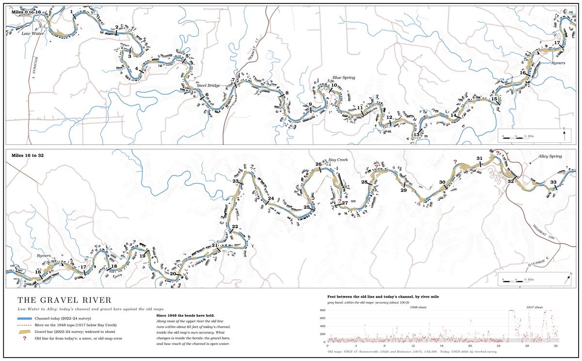
A river can also split. A flood can drop enough gravel to raise an islandJacobson, Femmer and McKenney 2001, 11., and the water divides around it into two or three threads. Measured across the whole river on 2010 photographs, only 25 of its 341 measuring points crossed three or more separate threads of water, in about six clusters. One of them was the Blue Spring bend, where the active channel was about 53 meters wide, some 175 feet, half again the river’s typical width, in a valley only about 100 metersErwin 2021, geomorphic metrics, points 42–47 (river median channel width 35 meters). across.
The record from the air
The bar maps cover both holes, and with care they can be read for 2005 to 2014. The four sets of photographs differ in season, method and flow. Water hides gravelsee Table 15.1 and the flows on the photograph dates., so a photograph taken at higher flow shows less bar than one taken at low water, and a bar map is only as comparable as the flows behind it. The 1996 pictures were taken in April, before the leaves were out, at four to five times summer flow, and mapped by a different methodErwin 2021, metadata; Erwin, Jacobson and Jones 2021, 11 (table 2); flows from USGS NWIS, gauges 07065495 and 07066000, April 16–17, 1996., so they cannot fairly be set beside the summer photographs. The three later years can be compared cautiously, with the flow on the photograph dates beside them (Table 15.1).
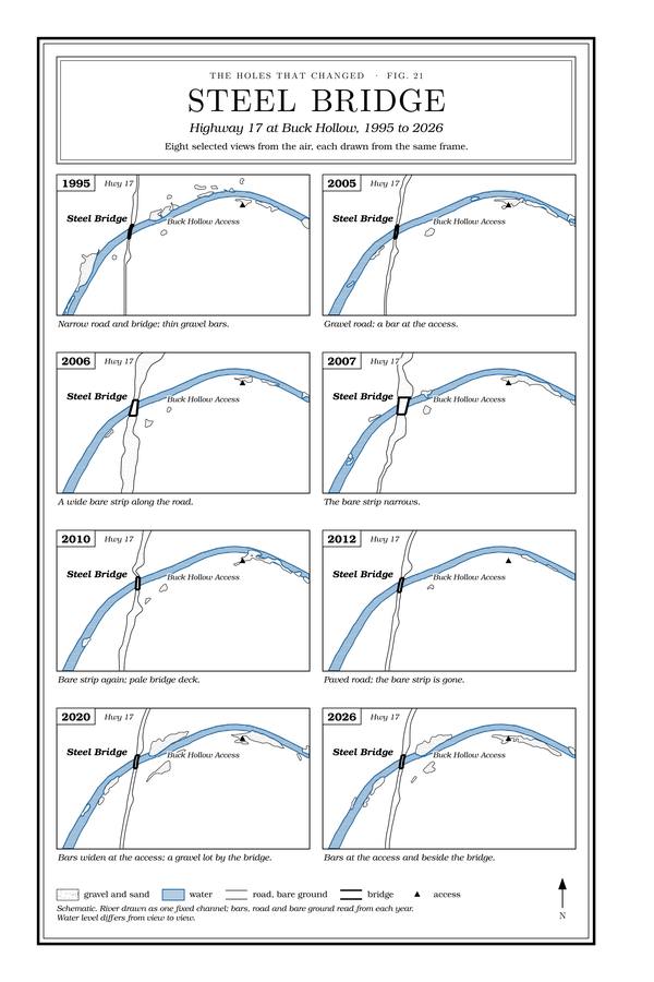
Figure 21 Steel Bridge, 1995–2026
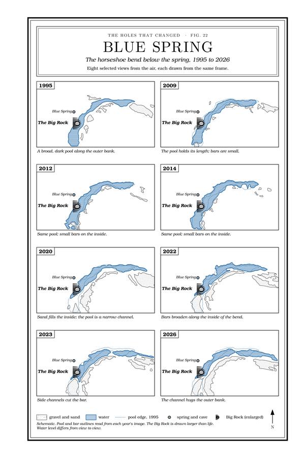
Figure 22 Blue Spring, 1995–2026
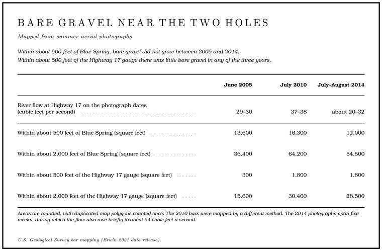
Areas are rounded, with duplicated map polygons counted once. The 2010 bars were mapped by a different method. The 2014 photographs span five weeks, during which the flow also rose briefly to about 54 cubic feet a second.
Close to Blue Spring, bare gravel did not grow between 2005 and 2014. In the wider circle it rose between 2005 and 2010, the years of the March 2008 floodthe highest daily mean at Alley between the 1996 and 2014 photographs (USGS NWIS, gauge 07065495); see Chapter 14., mostly about a quarter mile upstream and a third to a half mile downstream. Because 2010 was photographed at the higher flowErwin 2021, points 44 and 49–50; Erwin 2021, metadata., which should hide gravel, flow does not explain the rise, but the 2010 bars were mapped by a different method, and in this stretch of river the mapped share of gravel rises and falls with the methodErwin 2021, bar layers, points 23–49 (1.4, 4.2 and 1.9 percent in 2005, 2010 and 2014).. Only 2005 and 2014 were mapped the same way. At the Highway 17 bridge there was almost no bare gravel in any of the three years, and the nearest substantial bar, about a quarter mile downstreamErwin 2021, point 25., held steady or grew a little.
Through the summer of 2014, then, the bar maps show no bar growing into either hole, which agrees with the magazine writer’s “excellent swimming hole” of 2012 or 2013. They have three blind spots. They see only exposed gravel in plan view, as if from straight overhead, so gravel that fills a pool from the bottom never shows, and the mapping recorded nothing of the bed rising or fallingErwin, Jacobson and Jones 2021, 38 (“did not include information on vertical adjustment”).. Bars under the leaves of a narrow reach are easy to miss in summer photographs, since bluffs and streamside trees shade themMartin 2005, 38–39 (“shading effect of bluffs and riparian vegetation”).. And a bar that has grown up in willows is not counted as gravel at all.
Blue Spring, 1995 to 2026
Fig. 22 traces the bend from the same frame in eight years of aerial imagery. The rock stands on the outer, bluff side of the bend, with the spring’s cave set in behind it, and the bars build on the inside, the campground side. In 1995 a broad, dark pool lay along the outer bank, past the rock, with small bars on the inside. In 2009, 2012 and 2014 the pool held its length and the bars stayed small. In 2020 sand and gravel filled the inside of the bend, and the pool was a narrow channel against the outer bank. The bars broadened in 2022, side channels cut across them in 2023, and in 2026Fig. 22. the deep water still hugged the outer bank. The rock and the bluff did not move, so the change is measured against fixed points.
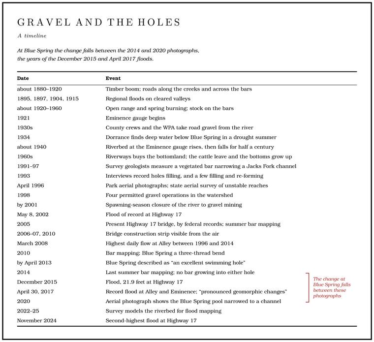
The change falls between the 2014 and 2020 photographs, and two great floods fall in that gap. The first came at the end of December 2015, when the gauge at Highway 17 reached 21.9 feet, its fourth-highest mark. The second, on April 30, 2017National Weather Service, gauge pages (JKFM7); see Chapter 14., set records at Alley and Eminence (Chapter 14). The 2017 flood made pronounced changes in the shape of the channelMcMurray and Faiman 2023, 18 (the 2017 flood “caused pronounced geomorphic changes in its channel”)., and it came after the last of the bar mappingErwin, Jacobson and Jones 2021, 39 (the flood “resulted in notable geomorphic change” after the period that study covered).. The flood of November 2024, second only to 2002National Weather Service, gauge pages (JKFM7). at Highway 17, came between the 2023 and 2026 images (Reach D).
The bend has looked different before. In a drought summer, probably 1934, a writer floating the river found it below Blue Spring running “deep and clear and indigo,” with “long, full-lipped ways between the shoals”Dorrance 1938, 29; for the year, see Chapter 9. (Chapter 9). It is one writer’s impression of a single drought summer, and it records deep water below the spring ninety years ago.
Steel Bridge, 1995 to 2026
Fig. 21 traces the river at the Highway 17 bridge from the same frame. In 1995 the road and bridge were narrow and the bars thin, and in 2005 the road was still gravel, with a bar at the access. In 2006 and 2007, around the building of the new bridgesee Chapter 8. (Chapter 8), a wide bare strip ran along the road on both sides of the river, narrowing by 2007. It showed again in 2010, with the pale deck of the new bridge, and by 2012 the approach was paved and the strip was gone. In 2020 bars had widened at the Buck Hollow access below the bridge, with a gravel lot beside the bridge, and in 2026 bars lay both at the access and beside the bridge. Through all those years the channel itself, under the bridge and around the bend to the access, stayed where it was, while the open water between the bars narrowedFig. 21 (the same frame and fixed points in every year)..
Which water the Steel Bridge swimming hole was matters for any measurement. A swimmer who spent every summer day of 1984, 1985 and 1986 at the bridge marked the deepest water right at the crossingJacks Fork Oral History, record SV-06.. A Mountain View resident who swam there remembered that “it was all gravel bar,” that people went in at the bottom of the hill on the west side of the road and swam “all up and down the bank by the bluff,” and that “the deepest water was along the bluff in the 70’s and 80’s.” The two marks lie within about Forty. Forty acres, a quarter of a quarter section. A hill farm was often one or two forties (Chapter 5). Glossary → metersthe two places marked on maps (records SV-06 and SV-20). of each other. Just below the bridge a pool under the north-shore bluff, Whitbeck Holesee Reach D., was the swimming hole of the old resort there (Reach D). The bluff the Mountain View resident remembered may be the same one.
Testing the explanations
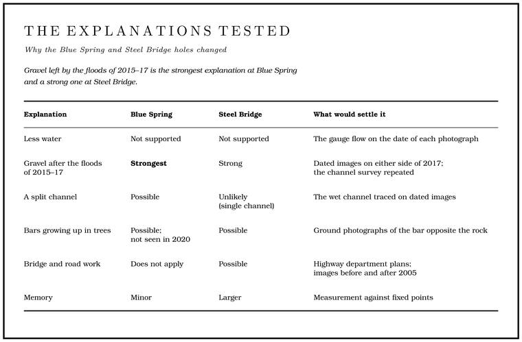
Each explanation for the change at the two holes can be tested against the evidence (Table 15.2).
Less water. If the river carried less water, the same channel would look narrower. Low-water measurements in the fall of 1966 and August 2006see Chapter 12. show nearly the same flow at Highway 17 and at Blue Spring (Chapter 12), and the gauge records show more water in the river in recent decadessee Chapter 14. (Chapter 14). Part of a gravelly river’s low flow travels out of sight between the stones of its bed, though, and the share can grow. As banks erode, the finer soil in them is carried off and the chert stays behind, so the bed becomes more gravelly over time, and a bed with more gravel in it carries more of the Base flow. The flow that keeps a river running between rains. On the Jacks Fork most of it comes from springs (Chapter 12). Glossary → undergroundThornberry-Ehrlich 2016, 37 (after Vana-Miller 2007 and Panfil and Jacobson 2001: “Increased gravel content can lead to shallower streams because base flow moves more easily through gravel than finer sediments”). and leaves a shallower stream on top. A hole’s edge moves with the water level, so a dry summer makes the bar wider and the water narrower. A drop of a few inches cannot turn a pool that had to be swum into one that can be crossed on foot.
Gravel after floods. The timing points here. The record flood at Highway 17 came on May 8, 2002Heimann and others 2025, 6 (table 1)., and through 2014 the bar maps that followed it show no bar growing into either hole. The change at Blue Spring appears between the 2014 and 2020 photographs, the years of the December 2015 and April 2017 floods, and the bars at Steel Bridge spread between the 2012 and 2020 photographs.
A split channel. Blue Spring was already a three-thread bend in 2010. If more of the river now runs down another thread, the water past the rock can shrink with no gravel dropped in the hole. The 2010 water outlines behind that count were not releasedErwin 2021; Erwin, Jacobson and Jones 2021, 8 (table 1)., so which thread passed the rock then cannot be read from the published data. Steel Bridge is a single channel.
Bars growing up in trees. The Blue Spring bars have not been grazed for half a century, and a bar that grows up in willows and sycamores pushes deep water against the far bank. Photographs of the bar opposite the rock, old and new, would show whether it has grown up. In the 2020 imageFig. 22 and the 2020 frame from which it was traced. the inside of the bend is bare sand and gravel.
The bridge and the road work. At Steel Bridge the most obvious change was the bridge itself, dated 2005 in federal bridge recordsNational Bridge Inventory; see Chapter 8., with its construction strip visible from the air in 2006 and 2007Fig. 21.. Long before that, gravel was taken at the bridgeJacobson and Primm 1994, 52. after floods, and the end of the digging could have let the pool fill. The bars near the bridge stayed small through 2014, so if the bridge work changed the hole, it did so under the water or slowly.
Memory. Every adult who goes back to a childhood place finds it smaller, and a child’s “over my head” is shallower water than an adult’s. At Blue Spring the comparison is anchored to a rock and a bluff that have not moved, and the aerial record shows the change. At Steel Bridge, with no single fixed rock and two candidate pools, memory weighs more heavily.
For the river’s flood maps, the depth along its deepest line, the Thalweg. The line of deepest water along a river’s course (Chapter 15). Glossary →, was sounded and the bridge cross-sections surveyed between December 2021 and May 2023. Those measurements were joined to lidar of the ground, a survey made by laser from the air, in a model of the valley from the South Prong access to within half a mile of the mouthHeimann and others 2025, 2, 4, 7; Heimann, Atkinson and High 2025.. The model records the riverbed at both holes as it was before the November 2024 flood, a baseline against which a later survey can measure the change at each hole.
Keeping the holes
No one can put a particular hole back. The gravel already in the river will keep moving for decades, and floods will dig some holes and fill others. The evidence points to the conditions under which holes form and re-form at something like the river’s own pace.
The strip of trees along the banks matters most. The condition of the streamside timber probably set the limit of how much disturbanceJacobson and Primm 1994, 86 (“Riparian conditions … probably defined the threshold of instability for Ozarks streams”). an Ozark stream could take before its channel came apart. In 2001 about 29 percent of the Jacks Fork’s length, 14.5 miles, had streamside corridors less than three-quarters forested, and about two-thirds of the length of each of the two Prong. A branch or arm of a creek, set down in 1860 as Southern usage. The North and South Prongs join to form the Jacks Fork (Chapter 18). Glossary →MDC 2001, PDF 98 (table Hc04; “non forested” there means grassland, cropland and urban cover together at 25 percent or more of the corridor; North Prong 64.9 and South Prong 68.7 percent).. The state conservation department set a goal, with willing landowners, of a 25 percent increase over twenty-five years in the streams with a wooded corridor more than 100 feet wide, and it ranked the North ProngMDC 2001, PDF 149 (objective 1.1). among the places where that would do the most good. Keeping cattle out of the streams, limiting gravel removal and building roads and crossings with care are the other parts of the same work (Chapter 17). Inside the park, vehicles may cross the river only at the authorized fordssee Chapter 8; NPS 2022a. (Chapter 8; Part Six).
Much of the best evidence about the holes came from people who paid attention: the men and women who remembered how deep a hole had been, and the swimmers who marked on a mapJacks Fork Oral History, records SV-06 and SV-20. where the deepest water used to be. A photograph of a favorite hole taken from the same spot each summer, with the date written on it and the gauge reading looked up, adds to that record.