On a summer afternoon most of what lives in the Jacks Fork stays out of sight. A floater may see a smallmouth at the edge of a run, a kingfisher flying ahead from bend to bend, or sunfish hanging still in a green Pool. A deep, slow stretch of river between riffles (Chapter 16). Glossary →. Under the boat, among the stones, are Mussel. A freshwater clam that lives half-buried in the riverbed and filters its food from the water. Mussels on the Jacks Fork fell sharply between the surveys of 1982 and 2017–19 (Chapter 16). Glossary → half-buried in the gravel, crayfish backed into crevices, Sculpin. A small, big-headed bottom fish of cold, clear water. The fish of the Current River system was named a separate species, the knobfin sculpin, in 2010 (Chapter 16). Glossary → pressed flat against the Bottom. The flat land along a river or creek, built of its deposits and open to its floods. In the 1920s the bottoms near Eminence averaged about a quarter of a mile wide (Chapter 2; Chapter 5). Glossary → and the larvae of mayflies and caddisflies clinging to the undersides of rocks.
All of them depend on a few things the river supplies unevenly from end to end: cold water, clean and stable gravel, steady flow, and leaves.
Two rivers by temperature
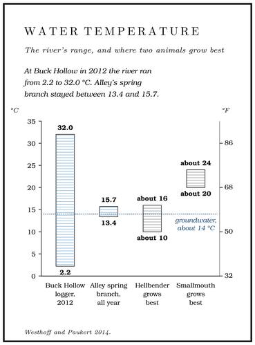
Above Alley Spring the Jacks Fork is mostly a rain-fed river, and below it a spring-fed one (Chapter 12). The difference shows on a thermometer. Water that has spent months underground comes out of the rock at close to the year-round average temperature of the ground it passed through, which in this country is about 14 °CWesthoff and Paukert 2014, 4, 10 (groundwater taken as a constant 14 °C; 14.2 °C at Alley Spring)., 57 °F, in January and August alike. Rain that runs off the hills straight into the creeks carries the temperature of the weather instead, so a river fed mostly by runoff runs near freezing in a cold winter and warms through the summer like a farm pondthe general behavior of runoff-fed water; Buck Hollow’s 2012 minimum was 2.2 °C..
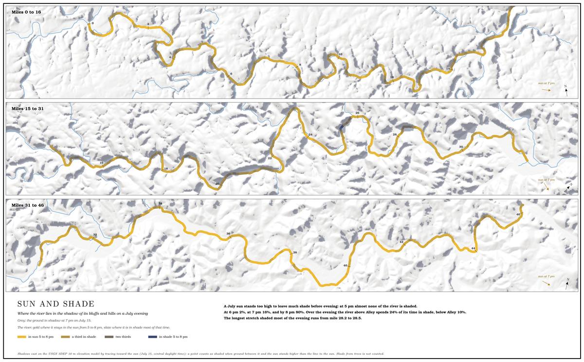
In 2012, one of the warmest and driest years on record, temperature loggers were set at 26 places along the Current and the Jacks Fork, most of them near river accesses or just above and below the big springs, and they took a reading every half hour through the year. Crews also floated both rivers twice, once in January and February and again in late July and August, with a probeWesthoff and Paukert 2014, 2, 10 (loggers generally within a few hundred meters of an access or just above and below the major springs, 25 of them recording every 30 minutes through 2012; boat surveys January 18–February 23 and July 30–August 15, 2012, reading every 30 seconds in winter and every 250 meters in summer). trailing behind the boat to read the water as they went. The logger at Buck Hollow, at the Highway 17 bridge, recorded the widest swing of any site in the park, from 2.2 to 32.0 °CWesthoff and Paukert 2014, 5; see Reach D., about 36 to 90 °F (Reach D). Buck Hollow gets very little groundwater.
Below Buck Hollow the river warms as it goes. The loggers at Rymers and Bay Creek, between Blue Spring and Alley, averaged about 17 °C, 63 °F, over the year, the warmest annual averages anywhere in the Riverways. It takes a large spring to change a river’s temperature. One supplying less than about 3 percent of the river’s summer flow had no measurable effect more than about 400 meters, a quarter mile, downstream, because its water was mixed into the larger, warmer flow and lost. Blue Spring was one of the few springs in the park big enough to move the river’s temperature by more than a degreeWesthoff and Paukert 2014, 6. Celsius.
Then comes Alley. The Spring branch. The stream that runs from a spring to the river, such as the branch below Alley Spring (Reach H). Glossary → ran between 13.4 and 15.7 °C all year and averaged 14.2 °C, a little under a degree warmerWesthoff and Paukert 2014, 6, 10 (14.2 ± 0.4 °C; 0.8 °C above the mean annual air temperature). than the average air temperature of the region. Below its mouth the river’s summer maximum dropped by about 10 °C, 18 °F, and its winter minimum rose by about 5 °C, 9 °F. No other single springWesthoff and Paukert 2014, 5–6. in the park changed its river as much. Above Alley a fish lives with what the weather gives it. Below Alley it has cool water in August and mild water in January.
The split runs through much of what follows: which fish are common where, how the mussels have fared in the upper and lower river, and where a Hellbender. A giant salamander up to nearly two feet long, flat and mottled brown, that needs cold, clean, flowing water. The Ozark hellbender was described from a Current River specimen in 1943, and by 2019 the Jacks Fork was thought to hold ten or fewer (Chapter 16). Glossary → might still live.
What the river eats
A river’s food comes from two places. Some grows in the water, as the thin film of algae on every sunlit stone. The rest falls in: leaves, twigs and the debris of the woods.
The balance between the two was measured in 1998 and 1999 on the Jacks Fork about two kilometers above Alley Spring. Biologists shoveled patches of streambed from Riffle. A fast, shallow, rocky stretch between pools. The riffles are the gardens of the riverbed: in July a square meter of riffle produced more than six times as much as a square meter of pool (Chapter 16). Glossary →, runs and pools into shallow pans, sealed each pan inside a plastic chamber set in the river, and read how much the oxygen in the chamber changed over two hours at middayWhitledge and Rabeni 2000, 166–67 (substrate in 23-centimeter pans inside plastic desiccator chambers, clear lids for net production and black lids for respiration; incubations from about 11 a.m. to 1 p.m. on July 7–9 and October 12–14, 1998, and May 25–27, 1999).. Algae give off oxygen as they grow, and everything living among the stones, from bacteria to insect larvae, uses it up. A chamber with a clear lid showed what was left after the using; one with a lid painted black, which shut out the light the algae need, showed the using alone. The riffles were the gardens. In July a square meter of riffle produced more than six times as much as a square meter of pool. The pools used more oxygen than they made in every season, because leaves and fine debris settle and rot there. Pans for this kind of work are sometimes left on the bed for some weeksWhitledge and Rabeni 2000, 166 (“which is sometimes done … to allow periphyton to recover”; the pans were also kept out because the chambers had to be moved to the right depth and current just before each run). beforehand so that the algae can recover from being disturbed, and on the Jacks Fork the biologists judged the risk of “burial or theft”Whitledge and Rabeni 2000, 165–69 (July: riffle 749, pool 111 milligrams of oxygen per square meter per hour). too high.
The Jacks Fork has a great deal of pool, and that is probably part of the reason its crayfish and other bottom animals get about two-thirds of their carbon from leaves and other land plants, a share worked out from the chemistry of their tissues and from what was in their gutsWhitledge and Rabeni 2000, 170 (the extent of pools “may partially explain” the dependence), citing Whitledge and Rabeni 1997, which used stable isotopes and gut analysis..
The animals that turn leaves into food are mostly insect larvae. Some 200 kinds of Aquatic invertebrates. The small animals without backbones that live on and in the riverbed, mostly the larvae of mayflies, caddisflies, midges and other insects, along with crayfish and snails. Some 200 kinds have been collected in the watershed since 1961 (Chapter 16). Glossary → have been collected in the watershed since 1961MDC 2001, PDF 112.. Between 2005 and 2014 the Park Service sampled three permanent stations on the upper Jacks Fork in most years, in late fall and early winter, when the river runs low and clearBowles, Morrison and Cribbs 2018, 67, 73 (samples taken November to early January; turbidity “nearly always below 10 NTU”).. At each station the crew worked three riffles, three samples to a riffle. Each time they set a square frame about 20 inches on a side on the bottom and scrubbed the cobblesBowles, Morrison and Cribbs 2018, 68 (Slack-Surber sampler, 0.25 square meter, 500-micrometer mesh; three samples from each of three riffles). inside it by hand, so that the current carried everything loose into a fine net behind. Most of what they caught were mayflies, stoneflies and caddisflies, insects that do poorly in polluted water. A sample is graded by giving each kind of animal a tolerance score, from 0 for one that needs very clean water to 10 for one that can live in badly polluted water, and averaging the scoresBowles and others 2011, 22 (the Hilsenhoff Biotic Index, 0 to 10). over every animal caught. The Jacks Fork stations never averaged worse than 4.4, and all three were rated unimpaired. They held somewhat fewer kinds than the Current River stations, and the stones in their riffles got smaller downstream, from an average of about 50 millimeters, two inches, at the upper station to about 41Bowles, Morrison and Cribbs 2018, 67–68, 71–73 (the communities “largely intolerant”). at the lowest.
Fish
Between 1941 and 1997 collectors recorded 67 kinds of fish in the Jacks Fork watershed, in 16 families (Table 16.1). Thirty-seven of them are characteristic Ozark fish, species whose range centers on these hills. Only two were introduced, carp and goldfish. The state’s fish commission reared more than 80,000 carp for stocking in the late 1800s. Neither carp nor goldfish has been caught in the watershed since 1980, and no stocking of either in its streams has been recorded since at least 1985MDC 2001, PDF 109–11..
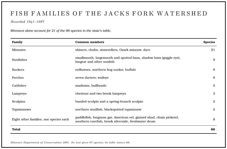
Not every species is still there. Seventeen kinds collected before 1981 were not found after 1980, among them the paddlefish, the walleye, the freshwater drum and the American eel. Most had turned up in only one or two collections. Two exceptions were the gilt darter and the American brook lamprey, each found at two sites and missed when biologists went back to the same places. The only species added after 1980 was the southern cavefish, from a single site in 1992MDC 2001, PDF 109–10, 128 (table Bc03); see Chapter 13. (Chapter 13).
Some of the missing fish stayed on local lists a while longer. One account of about 1980 still named the Jack salmon. The Ozark name for the walleye, a fish not collected in the Jacks Fork since 1980 (Chapter 9; Chapter 16). Glossary →, the Ozark name for the walleyesee Chapter 9., as the fisherman’s prize, and listed drum, chain pickerel and “occasionally shovel bills” among the river’s fish. By the same account a few trout once lived in Alley Spring, though they were seldom taken from the riverLewis 1980, PDF p. 27, the only source (“There is also the fisherman’s prize, the jack salmon, in the river”; the list also names grass pickerel, buffalo, carp, shad, redhorses and “long nose gar and other gars”; it does not say what it means by shovel bills)..
The record of fishing goes back further than the collections. The register of a Carter County club recorded catches on the Current and the Jacks Fork from 1889 to 1940see Chapter 9., and its catches fell as the timber boom passed (Chapter 9).
What a sample looks like. Every year from 2005 to 2009, in October or November, Park Service crews electrofished three permanent stations on the upper Jacks Fork, working from a boat and with gear towed behind them or carried on their backs. A pulse of mild current stuns the fish for a moment so they can be netted, identified, counted and let go. The catch is then scored on an index of stream health that runs from 0 to 100. A stream earns points for its darters, sculpins and madtoms, for fish that spawn on clean gravel and for fish that eat insects and other fish, and it loses them for diseased or damaged fish and for a large share of hardy kinds such as green sunfish, bluegill and bullheads, which hold on where others fail. A score of 60 to 80 counts as good and one above 80Dodd 2013, 4 (the index of biotic integrity of Dauwalter and others 2003, seven metrics; channel catfish are also counted among the tolerant kinds); mainstem means 62 to 89, Dodd 2013, 5. as excellent, and the Jacks Fork stations rated good to excellent. In number of kinds they resembled the upper Current, and in number of fish the middle and lower CurrentDodd 2013, 2, 5, 11 (pulsed-DC electrofishing from a boat, with towed-barge or backpack gear).. Table 16.2 shows what the crews caught in the first three years.
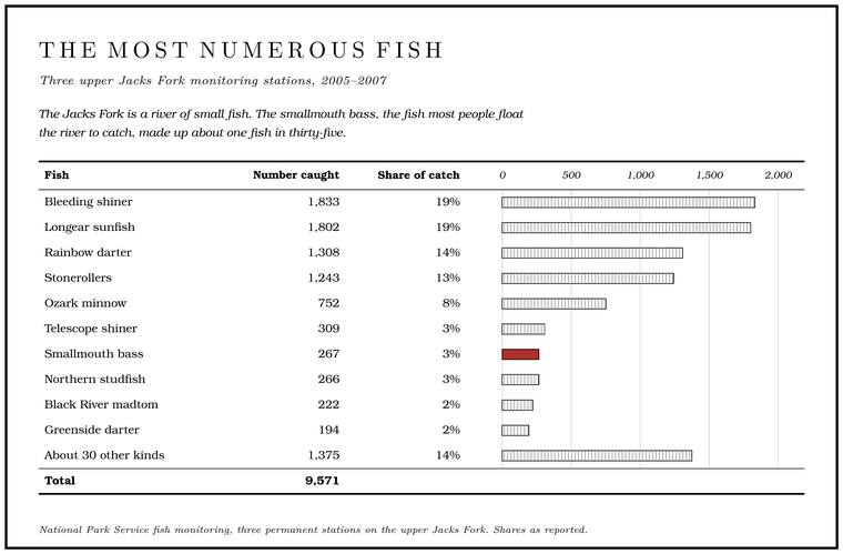
The Jacks Fork is a river of small fish. Shiners, stonerollers, darters and little sunfish made up most of the catch. The smallmouth bass, the fish most people float the river to catch, made up about one fish in thirty-five.
The common kinds. All four of the commonest kinds in Table 16.2 spawn on the river’s gravelfrom the four accounts that follow.. Stonerollers graze. A flat, shelflike extension of the lower jaw scrapes algae and ooze from the stones, and in early spring, from mid-March to late May, they dig shallow pit nests in small gravelMDC, “Central Stoneroller” (the account is of the central stoneroller; Table 16.2 counts the stonerollers together).. The bleeding shiner, a minnow of the Ozark uplands three and a half to four and a half inches long, takes its name from the breeding male, whose head, body and fins turn bright red. Bleeding shiners school in midwater over clean gravel, picking off insects that drift past on the current, and from late April to early July they gather in groups of a few to a hundred or more to spawn over gravel nests and pits that other fish have madeMDC, “Bleeding Shiner” (spawning “most often … over the gravel nests and pits made by other fish,” in groups of a few to a hundred or more).. The longear sunfish, the creek perch or sun perch of local speech, is blue-green speckled with yellow and emerald above and yellow or orange below, with a long black ear flap often edged in white. From mid-May into August the males fan out nests in small Chert. A hard, fine-grained form of silica that forms in nodules and beds inside dolomite and stays behind when the dolomite dissolves. Most Ozark people call it flint. It makes up the river’s gravel and was the stone of the first people’s tools (Chapter 1; Chapter 3). Glossary → gravel, crowded into colonies so tightly that the rims nearly touch, and each one fans his eggs and drives off intruders for more than two weeksMDC, “Longear Sunfish.”, until the fry have hatched and scattered.
The rainbow darter, never much more than three inches long, is the most abundant darter in most streams of any size but the smallest headwater creeks. From late March into May the breeding males, ringed with eight to eleven blue-green bars with orange-red between them, gather on fast gravel riffles. A female ready to spawn stops and buries the lower half of her body in the gravel, and the eggs are fertilized and buried there as the pair vibrate togetherMDC, “Rainbow Darter” (the female “stops and buries the lower half of her body in the gravel”)..
Smallmouth and goggle-eye
The smallmouth, the brown bass, brownie or bronzeback of anglers, is the Ozark stream bass, at home in clear streams with silt-free rock or gravel bottoms, near the riffles but out of the main current. It eats fish, crayfish and large insects. In spring, when the water passes 60 °F, the male sweeps a saucer-shaped nest clean of silt and fine gravel. A nest holds about 2,500 eggs on average and sometimes as many as 10,000, and the male guards the eggs and then the fry, which stay at the nest for about twelve days after hatching before they scatter. Most smallmouth run 10 to 20 inches, and some live ten or twelve yearsMDC, “Smallmouth Bass.”. The shadow bass, a member of the sunfish family, is the river’s Goggle-eye. The river’s name for the shadow bass, a sunfish, and in the state’s rules for the rock bass and its kin. The name was in use by 1840 (Chapter 16; Chapter 18; Part Six). Glossary →MDC, Jacks Fork Natural Area..
The state has managed the Jacks Fork’s smallmouth under special rules since the middle 1990s, as part of a study of how to manage high-quality stream fisheries. By 2000 the river from Highway 17 to Highway 106 carried an 18-inch minimum length and a limit of one smallmouth a day. Creel surveys, in which clerks on the river count the anglers and record what they have caught, ran from 1990 to 1998, and a first look at them showed that both the catch and the number of anglers had fallenMDC 2001, PDF 110, 129–30 (table Bc04; a preliminary analysis). since the rule came in, in the special stretch and outside it. The rules in force todaysee Part Six; MDC 2017 gives the special area and its limits at that date. are in Part Six.
Interviewed in the early 1990s, people who had fished the river for decades disagreedJacobson and Primm 1994, 40 (table 6), 60–62. about whether the fishing had changed. Some blamed overfishing for a decline and others thought there were more fish than before. A man who had fished the upper river since the middle 1930s said the same kinds of fish were there as always and the smallmouth were bigger under the 12-inch length limit of his day. “I can’t believe,” he added, “that the total number of fish can be as much with what is to me an obvious decrease in the total volume of standing water.” The filling of the Hole. Any pool deep enough to swim or fish in, named or not, the basic unit of the river in local speech; also “hole of water” (Chapter 18). Glossary → is the subject of Chapter 15.
Temperature matters to a smallmouth, which grows best between about 20 and 24 °C, 68 and 75 °F. A fish’s body runs at the temperature of the water around it, so in colder water it feeds and grows slowly, and in water much warmer than its best range it spends more on living than it can take in. In projections of the Riverways’ climate to the 2080s, the best growing days shift toward the spring-cooled reaches, and the most spring-fed water stays about 3.5 °C coolerWesthoff and Paukert 2014, 8 (table 3, under both climate models). than the water with the least spring in it. Smallmouth in the Riverways have been known to move more than 40 kilometersWesthoff and Paukert 2014, 8, 10–12., about 25 miles, far enough to reach the cooler water below a big spring.
Sculpins and studfish
A brown, wide-headed fish that darts a few inches from under a flat rock in a riffle and vanishes again is a sculpin. Sculpins have no swim bladder, the gas-filled sac that lets most fish hover in midwater, so they sink and stay on the bottom. Their heads are broad and flat and their pectoral fins large, which helps them hold their place in fast water. They have no scales, only small prickles. By day they hide under rocks, and at night they feed on crayfish, insect larvae, snails and small fish, other sculpins included. In spring the male digs a cavity under a rock or log, the female turns upside down to glue her eggs to its ceiling, and the male guards them for about a monthMDC, “Banded Sculpin.” until they hatch.
Two sculpins live in the Jacks Fork. The banded sculpin is the most widespread sculpin in Missouri and generally the commonest in the larger and warmer Ozark streams, tolerant of warmer waterMDC, “Banded Sculpin.” than its relatives. On the Jacks Fork it eats young crayfishDiStefano and others 2003, 356.. The other is a spring-water fish. Older lists call it the Ozark sculpin, but in 2010 biologists described the fish of the Current, Eleven Point and White river systems as a separate species, the knobfin sculpinMDC, “Knobfin Sculpin.”, named for the fleshy Knob. The old Missouri name for a hill of hard volcanic rock, such as those near Eminence and the mouth (Chapter 1). Glossary → on the tips of the males’ fin spines. It lives in cool and cold spring-fed creeks and can be the most abundant bottom fishMDC, “Knobfin Sculpin.” in an Ozark spring branch. In the large spring branches of the Riverways, sculpins were the commonest fish in mostBowles and others 2011, 28 (with “banded sculpin” and “knobfin sculpin” dominant in most springs)..
The studfish, a topminnow long known as the northern studfish, has a surprise in its name. A male collected in the Jacks Fork near Alley Spring was the model for a published scientific illustration of the group. In 2017 genetic comparisons showed that the studfish of the Ozarks belong to a different species from the northern studfish of the Tennessee River systemHundt, Berendzen and Simons 2017, 462, 470–71 (the northern studfish’s range there includes the Buffalo River of Tennessee). of Alabama and Tennessee. The Ozark species was formally named in 2025 as Fundulus cryptocatenatus, and the old name, Fundulus catenatus, now belongs to the studfish of the Tennessee drainage aloneFast and others 2025, 309–28 (F. catenatus restricted to the Tennessee drainage, F. caddo named for the Ouachita Highlands, F. cryptocatenatus for the rest of the former range; type locality the North Fork of the White River, Ozark County, Missouri, 319)..
Six of the fish recorded in the Jacks Fork Natural Area live nowhere outside the Ozarks: the Ozark madtom, the checkered madtom, the Ozark shiner, the Current River saddled darter, the Ozark chub and the Ozark sculpinMDC, Jacks Fork Natural Area, the state’s list for the natural area.. Two of those names have since changed. The Ozark sculpin of the Current River system is the knobfin sculpin, and the madtom caught in the park’s fish monitoring on the Jacks Fork is recorded as the Black River madtomDodd 2009, appendix 2 (Noturus maydeni).. The Ozark shiner, now placed in the genus ParanotropisMDC, “Ozark Shiner” (Paranotropis ozarcanus)., is a species of conservation concern in Missouri, and the monitoring crews caught ten in three yearsMDC 2001, PDF 143 (table Bc07); Dodd 2009, appendix 2.. The Current River saddled darter, once ranked a subspecies, is now usually treated as a full species, Etheostoma erizonumITIS, Etheostoma erizonum (TSN 1148994; raised from E. euzonum erizonum by Near and others 2011). The rank differs among authorities..
Gar
The long, narrow fish that cruise the clear poolsDufur 2013, 19. are longnose gar, the only gar of the clear, fast streams of the central Ozarks. Adults keep to the larger, deeper pools, and the young grow up in shallow backwaters among the water plants. After its first few days a gar eats almost nothing but fish. It takes a minnow by ambush, holds it until it stops struggling, and swallows it headfirst. Gar commonly reach about three feet, and the largest in Missouri about five feet and thirty pounds. Males seldom live past eleven years, while females can live twenty or more. By late April the adults have moved upstream, and from early May to mid-June they scatter their eggs over shallow gravel riffles without making a nest. The eggs hatch in six to eight days, and they are highly toxic to warm-blooded animals, people included. Anglers have long counted the gar a worthless nuisance that competes with better fish, and its local names include billfish and billy garMDC, “Longnose Gar.”. On the upper river the name went onto a pool, Gar Hole, whose place is now uncertainsee Chapter 18. (Chapter 18).
Mussels
A freshwater mussel spends its life half-buried in gravel, often in the same spot for decades, drawing water in through one opening and out another and straining plankton from it. Raccoons, otters and fish eat mussels, and because a mussel cannot move far, it records what the river has been doing.
Its young need a fish. A male releases sperm into the water, and a female Draw. A valley, in the usage of the Eleven Point side of the divide in Howell County (Chapter 18). Glossary → it in and fertilizes her eggs inside her gills, where they are brooded. The eggs become microscopic larvae called Glochidia. The microscopic larvae of a mussel, which clamp onto the gills or fins of a fish and ride there for two to four weeks before dropping off as young mussels (Chapter 16). Glossary →, which must clamp onto the gills or fins of a fish, usually of particular kinds, and ride there for two to four weeks while they change into juvenile mussels. Then they let go and drop to the bottom, and those that land on good, stable gravel may live for many years, some for a century or more (Fig. 16.1). Some mussels lure their fish with a flap of flesh shaped like a minnow, and others release their larvae in packetsMcMurray 2017. that look like the fish’s food.
The system depends on the right fish being in the right place at the right season. The slippershell mussel uses the banded sculpin as a host, and the banded sculpin’s tolerance of warm water may explain why slippershells have turned up in the upper Jacks Fork, where spring water is scarce. The fragile papershell’s only known local host is the freshwater drum. Drum have been recorded once in the Jacks Fork, and the papershell’s only live record in the whole Current River system is from the Jacks Fork, in 1982Westhoff, Laszlo and Huggins 2026, 37–38..
The Ouachita kidneyshell, which now makes up mostsee Thirty-five years of counting. of the Jacks Fork’s mussels, is one of the lure-makers. Biologists examining kidneyshells in the spring of 1994 found what looked like dozens of tiny larval fish lined up in rows inside the gills. Each was a packet of about 300 glochidia, marked with four eyespots. The female lets the packets go with the water leaving her gills, and a sticky thread anchors each one to a rock or a stick, where it twirls in the current. A small fish that bites one bursts the eyespots and takes the larvae onto its gills. Of twelve kinds of fish tested as hosts, only dartersBarnhart and Roberts 1996 (the packets lined up “like matches in a matchbook”). carried the kidneyshell’s larvae through to young mussels. Darters are plentiful in the Jacks Fork, and the rainbow darter alone was about one fish in sevenTable 16.2 (1,308 of 9,571). in the monitoring catch (Table 16.2).
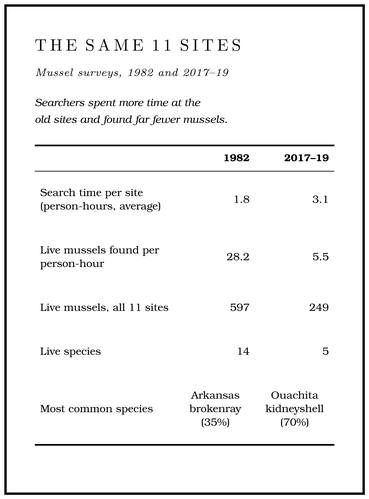
Thirty-five years of counting. Nineteen kinds of mussels have been recorded in the Jacks Fork watershed, of forty-three in the Current’sVana-Miller 2007, viii.. Mussels were collected in the Jacks Fork from 1967 to 1979 with no record of how hard anyone searched. In 1982 a state biologist surveyed 11 sites and kept field notes on where he searched and for how long. A Park Service inventory in 2002 covered three Jacks Fork sites. In 2017–19 state biologists returned to the 11 sites of 1982, using his notes to search the same water, and added 17 new sites chosen for good mussel habitatMcMurray and Faiman 2023, 11–12.. At each site at least two searchers waded or snorkeled through every kind of habitat, feeling through the gravel by hand as well as looking, and kept timeMcMurray and Faiman 2023, 12–13 (timed tactile and visual searches of all habitats, wading or snorkeling).. A count divided by the hours spent searching, in live mussels per person-hour, lets a short search by two people be set fairly beside a longer one by three.
The results were stark (Table 16.3). At the 11 repeated sites the searchers spent more time than in 1982 and found far fewer mussels: about 28 live mussels per person-hour in 1982, about five and a half in 2017–19. Live species at those sites fell from 14 to 5, and no species had appeared at any old site. The Arkansas brokenray, the commonest mussel at those sites in 1982 with 206 found, was down to 17. The Ouachita kidneyshellMcMurray and Faiman 2023, 13–17. held nearly even, 184 then and 173McMurray and Faiman 2023, 17 (table 4, live counts at the 11 sites). in 2017–19, and so made up most of what was left. At the old sites at Alley and at Eminence there were no live mussels at all. Across all 28 sites the searchers found 1,058 live mussels of six species, nearly three-quarters of them Ouachita kidneyshells.
The survivors are not spread evenly. Every measure was better above Leatherwood Creek than below it. Most of the sites between about Ratcliff Ford and a little below Rymers held 30 or more live mussels per person-hour, and one site in that stretch held 331. None, alive or dead, turned up at five sites on the North and South Prong. A branch or arm of a creek, set down in 1860 as Southern usage. The North and South Prongs join to form the Jacks Fork (Chapter 18). Glossary →McMurray and Faiman 2023, 14–15. The source gives sites by river kilometer only; the place names here are located from those distances, and the stretch also held two poor sites, near Steel Bridge and at Rymers..
The Park Service’s survey of 2023–24 went about it differently. Instead of going to known mussel beds, crews of three made two 45-minute searches at each of a set of randomly placed points, in water less than about a meterWesthoff, Laszlo and Huggins 2026, 6 (three surveyors, two 45-minute searches within 500 meters of each point, in water under 1 meter; rocks larger than cobble were not moved). deep. A random design samples the whole river more evenly and can miss its best beds, so its numbers cannot be set directly beside the earlier counts, though they were lower still: 3.4 live mussels per person-hour on the Jacks Fork, against 14.6Westhoff, Laszlo and Huggins 2026, 35 (“possible continued decline”; the authors caution that the designs differ). across the 28 sites of 2017–19. The pattern held. The upper reaches held more mussels than the lower, perhaps because their beds are made of larger, more stable stones, and the richest sitesee Reach D. in the whole park lay a short way below Steel Bridge (Reach D). Five of the 18 Jacks Fork sites had no live mussels. Four species recorded in 2017–19, two of them only as old shellsMcMurray and Faiman 2023, 15–16 (giant floater and spike as weathered or subfossil shells)., were not found: the slippershell, the creeper, the giant floater and the spike. Seven species have gone unrecorded in the Jacks Fork since at least 1982. The crews found nothing like the beds of hundreds or thousands of mussels known in some Ozark streams of similar size. Even so, the Jacks Fork held more live mussels than either stretch of the CurrentWesthoff, Laszlo and Huggins 2026, 18–19, 35, 41..
The causes. No single cause has been found, and declines like this one, steep and with no plain culprit, have been recorded in many American streamsMcMurray and Faiman 2023, 18 (“As is the case for many streams in the USA, the mussel decline in the Jacks Fork is enigmatic and its causes are unknown”).. Several suspects have been weighed. The great floodsee Chapter 14. of April and May 2017 (Chapter 14) reshaped the channel just before the 2017–19 survey began, but few freshly dead shells turned up, which a sudden kill would leave, and mussels are adapted to a bed that moves now and then. A lower stretch of the river has had high counts of fecal bacteria, and failing septic systems can also leak ammoniaMcMurray and Faiman 2023, 18., which is toxic to mussels; when dissolved ammonia was measured below Alley in 1999 and 2000, it did not differ significantlyDavis and Richards 2002, 34; see Chapter 17. from site to site (Chapter 17). In 2023–24 mussels were scarcer in riffles and in loose sand, gravel and cobble, and the Gravel wave. A body of gravel set loose by land clearing that moves slowly down a river over decades (Chapter 15). Glossary →Westhoff, Laszlo and Huggins 2026, 36; see Chapter 15. still moving down the Riverways from past land clearing keep some reaches unstable (Chapter 15). Across the Current River basin, native Ozark fish such as smallmouth and longear sunfish have been giving ground to generalists such as spotted bass and bluegillWesthoff, Laszlo and Huggins 2026, 38 (after Morrill and others 2023)., which could leave some mussels short of their hosts.
The pattern of loss says something about time. The short-lived species went first. The only mussels that gained in share were long-lived ones, the Ouachita kidneyshell and the Ozark pigtoe, and whether they are still raising young is not known. Ecologists call this situation an Extinction debt. A loss that has already happened but shows in the counts only as the old animals die, as when long-lived mussels outlast the end of their own breeding (Chapter 16). Glossary →. When a population stops raising enough young, the adults can live on for decades, so a loss that has already happened shows in the counts only as the old animals go. Unless the kidneyshell and the pigtoe are raising young, they too can be expected to decline as the remaining adults dieMcMurray and Faiman 2023, 16–18 (no colonization by any species at the 11 sites; local populations “hold an extinction debt from which additional extirpations should be expected,” after Gotelli 2001 and Vaughn 2012)..
Crayfish
Mussels are scarce and crayfish are everywhere. Four kinds live in the river: the golden crayfish, by far the commonest, and three that are found only in the Ozarks and nearby, the Ozark crayfish, the spothanded crayfish and Hubbs’ crayfish. A fifth lives undergroundMDC 2001, PDF 111; DiStefano and others 2003, 345; see Chapter 13. (Chapter 13). The Current River watershed as a whole has fourteen kinds, and the Black River drainage, which takes in both the Current and the Jacks Fork, has been ranked among the top conservation priorities of the Ozark Plateaus for the number of its crayfish and the range of habitats they needVana-Miller 2007, viii, xi (“because of the taxonomic richness and diverse habitat requirements of its crayfish species”)..
From 1991 to 1998DiStefano and others 2003, 346–49, 357–58 (“some of the highest crayfish densities measured in any streams”); see Reach D. state biologists sampled two reaches of the upper river, one at Ratcliff Ford and one at Blue Spring (Reach D). Their sampler was a square-meter frame of angle iron, netted on three sides, with a mesh bag on the downstream side. With the frame set on the bottom, the gravel inside was raked for three to five minutes to a depth of at least six inches, and the current swept whatever was dislodged into the bag. Each site got 63 to 65 squares a year. Crayfish shelter in the gravel by day and come out at nightDiStefano and others 2003, 347–48 (frame 0.51 meter high, 2-by-3-millimeter mesh, raked to at least 15 centimeters)., so a daytime sample finds them at home. Golden crayfish made up two-thirds to three-quarters of the catch, at least ten to the square meter in every kind of habitat and more than twentyDiStefano and others 2003, 349 (golden crayfish per square meter). in many backwaters, and most were that year’s young, crowded into the shallow edges. The richest places were small: backwaters, and the patches of water willow, the narrow-leaved plant that grows in clumps along shallow margins. The densities there rank among the highest measured in any stream. The patches are nurseries. Midge larvae and mayflies are thick in them, and young crayfish eat those along with rotting leaves.
Each species keeps its own address. The Ozark crayfish favors pools, backwaters and vegetation. The spothanded crayfish, the largest and fastest-growing crayfish in the river, lives mostly in the water-willow patches and backwaters. Hubbs’ crayfish is present in very low numbersDiStefano and others 2003, 343, 345, 349, 355 (golden crayfish 68 percent in summer, 76 in autumn, p. 349)..
The margins are also the easiest places to ruin. Clearing streamside timber and letting livestock into the river bring faster channel shifting, more gravel and bigger bars, and gravel mining adds fine sediment that fills the spaces young crayfish use. Crayfish are the hinge of the river’s food web. They eat leaves and insects, and nearly everything larger eats them. Madtoms, young smallmouth and banded sculpinsDiStefano and others 2003, 356, 358–59. take the young, and smallmouth, hellbendersMDC, “Smallmouth Bass”; USFWS 2020, 6. and herons take the adults.
The hellbender
The Ozark hellbender is a giant salamander, up to nearly two feet long, flat and mottled brown, with loose folds of skin along its sides. It takes much of its oxygen through that skin and needs cold, clean, flowing water. By day an adult wedges itself under a large flat rock, and at night it hunts, mostly for crayfish. Its home range is small, a few dozen square meters. In fall the male guards a nest under a rock where a female has laid a few hundred eggs, which hatch after about six weeksUSFWS 2020, 4–6 (adults 11–22 inches; home ranges 28–81 square meters; 150–350 eggs)..
The animal has gathered names. “Hell-bender” was in print by the 1810s, when the eastern hellbender was already known in the United States by that name and as the alligatorMerriam-Webster (river words), “hellbender” (first known use 1812); Frétey and Raffaëlli 2021, 35–51 (Barton’s account of 1814, whose title gives the animal as known “in the United-States, by the names of alligator and hell-bender”).. Where the name came from is not known. Early writers tied it to the tortures of the underworld, on account of the undulating, wrinkled skin, and the story goes that one angler took the thing for a creature from hell, bent on getting back there. Hellbenders have also been called mud-devils, water-dogs, alligators of the mountains and walking catfish, and more lately snot otters and “old lasagna sides,” for the ruffled folds along the flanks. The slime on the skin can irritate the hands that hold one, but a hellbender is not dangerousBriggler 2004 (the name linked to “horrible tortures of the infernal regions”; one angler’s “a creature from hell where it’s bent on returning”; the slime “a mild skin irritant”); Pritchard 2025 (the etymology “unclear”)..
The Ozark hellbender lives only in a few rivers of southern Missouri and northern Arkansas. It was described in 1943 from a specimen taken in the Current River at Big Spring Park, in Carter CountyUSFWS 2020, 2 (“from a specimen collected from the Current River in Carter County”); Frétey and Raffaëlli 2021, 35–51 (the type locality “Current River at Big Spring Park, Carter County, Missouri,” after Grobman 1943).. Missouri listed it as endangered in 2003MDC, “Ozark Hellbender.”, and the U.S. Fish and Wildlife Service followed in 2011USFWS 2020, iii.. The Jacks Fork’s record is short:
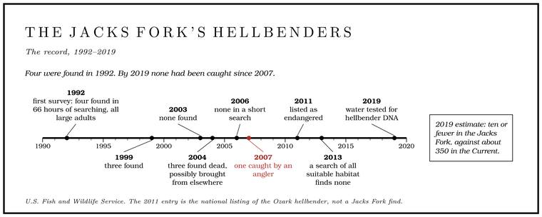
- 1992: the first survey found four hellbenders in 66 hours of searching, all large adults, 13 to 17 inchesUSFWS 2020, 17. long.
- 1999: three found.
- 2003: none.
- 2004: three dead hellbenders found on the upper end of the river, possibly animals brought there from elsewhere.
- 2006: none in a short search.
- 2007: one caught by an angler.
- 2013: a survey of all suitable habitat in the river found none.
- 2019: water samples from two sites tested for hellbender DNA; none was foundUSFWS 2025, 6 (“eDNA sampling at two sites in 2019 did not result in any positive detections,” citing Crabill 2020, unpublished data)..
The water test of 2019 looks for traces of the animal. A hellbender sheds skin cells and slime into the water around it, and a sample of river water, filteredthe general method of environmental-DNA sampling. and tested in a laboratory, can show that the species has been there lately without anyone turning a rock. By 2019 the Jacks Fork was thought to hold ten or fewer hellbenders, against about 350 in the Current, and none had been caught there since 2007USFWS 2020, 18–20 (table 3-1).. The estimate was still ten or fewer in 2025, and a few may remainUSFWS 2025, 6–7 (table 1, 7).. The river still has large rocks, bedrock bottoms and ledgesUSFWS 2020, 24. that look like good habitat. Temperature may be part of the story. A hellbender grows best between about 10 and 16 °C, 50 and 61 °F, and in the 2014 model of the Riverways the days too hot or too cold for it fell only in the stretches with the least spring waterWesthoff and Paukert 2014, 8..
The Current River population is the focus of an intensive rescue. In the fall of 2011 the Saint Louis Zoo bred Ozark hellbenders in captivity for the first time anywhere. Wild-bred adults spawned in artificial nest boxes set in outdoor streams built at the zoo, two of them, each Forty. Forty acres, a quarter of a quarter section. A hill farm was often one or two forties (Chapter 5). Glossary → feet long and six feet deep and landscaped with natural gravel and big rocks to hide under, and the first larva hatched on November 15. At the time fewer than 600 Ozark hellbenders were thought to be left in the world, of as many as 8,000MDC 2011 (hellbenders). The adults kept indoors at the zoo came from the North Fork of the White River; the release does not say where the spawning pair came from, or in which of the two streams the eggs were laid. that had once lived in the rivers of south-central Missouri and northern Arkansas. In 2019 the hellbender was named Missouri’s official state endangered speciesMDC, “Ozark Hellbender.”. The zoo has since bred Current River hellbenders, 1,410 captive-raised young had been released into the Current by 2020, and 34 artificial nest boxesUSFWS 2020, 42–43. had been set in its bed. In October 2022 biologists found a tagged, zoo-raised male in the Current guarding a nest of 128 eggsPritchard 2025.. The threats include silt, poor water, disease, illegal collecting and the boats and vehicles that strike hellbenders or shift their rocksUSFWS 2020, 31–32.. Driving through the riversee Chapter 8. where there is no crossing can crush or move the same rocks (Chapter 8).
The spring branch at Alley
A spring branch is a world of its own, cold, clear and nearly the same temperature day and night, summer and winter. Alley Spring’s Branch. A small creek. The sense is American, on record from 1674 (Chapter 18). Glossary → runs about 800 meters, half a mile, from the spring to the river, and it averaged just under 14 °CBowles and others 2011, 6 (table 2), appendix B., 57 °F, in the monitoring years. It holds the richest plant community of the Riverways’ large springs. Twenty-one kinds of plants were counted in the sample plots there between 2007 and 2015, more per plot than in any other large spring in the park. The commonest were mosses, bulbous bittercress and watercressBowles and others 2011, 11–12.Bowles and Dodd 2016, v, 3–4., a European plant that is the commonest non-native in the park’s springs. Star duckweed, a small floating plant, grows in the springs as well.
Of the large springs Alley also had the most kinds of aquatic insectsBowles and others 2011, 22. and other small invertebrates, and its fish community was among the richest. In the faster, simpler spring branches elsewhere in the park, sculpinsBowles and others 2011, 26–28. made up most of the fish.
Under the river lies another community. The southern cavefish, the Salem cave crayfish and the cave salamanders of the Jacks Fork’s caves, and the gray batssee Chapter 13. that roost in them and feed at dusk on the mayflies, caddisflies and stoneflies that rise from the riffles, are the subject of Chapter 13.
Bluffs, talus and the plants of a colder time
The Bluff. A cliff along the river, usually on the outside of a bend, where the river has cut sideways into the hill. In this sense the word was first used in North America (Chapter 2; Chapter 18). Glossary → are the river’s most visible habitat. In the Jacks Fork Natural Area, three miles of the canyon a little below Blue Spring, cliffs rise more than 200 feet above the water, to about 250 near Jam Up Cavemeasured on the flood-mapping terrain (Heimann, Atkinson and High 2025; Map 13): the right-bank face at about mile 12.76, about 250 feet, and Red Bluff, on the left at 13.14 to 13.33, about 230; see Chapter 2 and Reach E. MDC, Jacks Fork Natural Area, gives “as much as 200 feet.”, and old eastern red cedars grow from their ledges. More than 450 native plant species have been recorded on the Natural area. A Missouri tract set aside as one of the best remaining examples of the state’s native communities, to be managed to keep it that way. The Jacks Fork and Barn Hollow natural areas were designated on May 27, 1980 (Chapter 11). Glossary →’s 966 acres. The state designated it on May 27, 1980MDC, Jacks Fork Natural Area., the same day as Barn HollowMDC, Barn Hollow Natural Area., a side canyon of the upper river north of Mountain View.
The river’s bends set up a natural experiment. A bluff facing south or west bakes all afternoon, while one facing north or east is out of the afternoon sun and stays shaded, cool and damp, and dry cliffs and moist cliffsMDC, “Cliffs.” often stand within sight of each other with different plants on them. Water seeping out of a shaded face cools it further as it evaporates. On the cool, moist faces grow some plants left over from a colder past, harebellMDC, Jacks Fork Natural Area (relicts); see Chapter 1. among them (Chapter 1). During the last glacial period spruce forestSmith, Swanson and Leis 2008, 4. grew in the Ozarks, and as the climate warmed the northern plants retreated, except where a pocket of the old climate held on. A shaded, seeping cliff is such a pocket. As of 1999 the last dated records of harebell, northern bedstraw and false bugbane in the watershed were from the 1980sMDC 2001, PDF 143–47 (table Bc07, from the state’s Natural Heritage Database: harebell 1984, northern bedstraw 1987, false bugbane 1985)., though harebell still grows on the natural area’s cliffsMDC, Jacks Fork Natural Area; Dufur 2013, 21, names harebell and false bugbane as present.. At Barn Hollow the forked aster, another plant of cooler country, grows along the creek and on the moist north-facing bluffs, which rise up to 100 feet.
In spring floaters see fire pinks, wild columbine growing from bare rock, limber honeysuckle, phlox and violets, with walking fern and maidenhairDufur 2013, 21. fern in the seeps. A Park Service folder of 1977 pointed floaters to the mouth of Leatherwood Creek as one placeNPS 1977, Jacks Fork stop 9. to see the mix, with plants of the Appalachians on the cool bluffs and ridges, southern plants in the low wet places and plants of the dry West in the Ozark woods, “a botanical mix at the temperate center of the continent.”
Below many bluffs lies Talus. A slope at the foot of a bluff covered with loose rock fallen from the cliff above (Chapter 2). Glossary →, a steep apron of fallen rock, hard ground for trees, which are scarred and knocked down by falling stone. It shelters salamanders, and snakesMDC, “Talus.” spend the winter in its crevices.
Cottonmouths and watersnakes
The Jacks Fork has long had a reputation for cottonmouths, and the stories have grown in the telling. Snakes “as big as a man’s arm and six feet long” turn up in them, along with snakes that climb into boats and run fishermen out of the water. One tale concerns a man who liked to fish a surface lure for bass at night. Time after time he heard the slap of a strike and could never land the fish, until he turned his flashlight on the water and saw that the thing on his lure was a big cottonmouthLewis 1980, PDF p. 31, the only source (the man “liked to jitterbug for bass at night”; “his Junker was a large cottonmouth”).. Another, from Leatherwood Creeksee Reach F., is told in Reach F.
The northern cottonmouth is a heavy-bodied, venomous snake, dark olive-brown to nearly black, typically three to four feet long and known to reach a little more than six. Alarmed, it opens its mouth wide to show the cotton-white lining that gives it its name, and it swims with its head up and its back out of the water. In Missouri it lives mainly in the southeastern lowlands, with scattered populations in the Ozarks in cool, spring-fed, rocky creeks and small rivers, and it often spends the winter in crevices along the bluffs, in dens it shares with other snakes. It eats mostly fish and frogs, and a female bears two to fifteen young, usually in August or September and only every other yearMDC, “Northern Cottonmouth” (“known to reach 75 inches”).. Many people take the harmless watersnakes for itMDC, “Northern Cottonmouth”; Lewis 1980, PDF p. 31 (“Many people mistake banded water snakes and other harmless creatures for the viper”).. The common watersnake of clear, cool, gravel-bed streams bites hard and smears a foul-smelling musk when it is caught, but it has no venom. It is lighter in build than a cottonmouth, with a smaller head, no pit between the nostril and the eye and no light line from the eye to the corner of the mouth, and it is often killed by mistakeMDC, “Northern Watersnake” (the midland subspecies, of the southeastern third of the state, prefers “clear, cool, gravel-bed streams”)..
Glades and fens
Two kinds of small open ground matter more than their size. Glade. An opening where bedrock lies at or near the surface and the soil is too thin and dry for trees, usually on a south-facing slope (Chapter 16). Glossary → are openings where bedrock lies at or just under the surface and the soil is too thin and dry for trees. In the Riverways the Dolomite. Calcium magnesium carbonate rock, a close relative of limestone, formed from lime mud on the floor of a warm, shallow sea. Nearly every bluff on the Jacks Fork is dolomite (Chapter 1). Glossary → glades lie almost all on south-facing slopes, and prairie plants grow among the rocks. Near the mouth of the Jacks Fork, where the old volcanic rock comes to the surface (Chapter 1), there are Rhyolite. A volcanic rock at least 72 percent silica, the rock of the knobs near Eminence and the mouth. Much of the rhyolite here is tuff (Chapter 1). Glossary → glades as well. Sixteen dolomite glades have been recorded in the Jacks Fork watershed. Glades need fire. A fire running through a glade kills the young red cedars, which cannot sprout again from the rootthe general fire ecology of eastern red cedar. as an oak can, and leaves the grasses to come back from their roots. Without it, red cedar and other woody plants move in and shade the glade out, and woody invasionSmith, Swanson and Leis 2008, 2–3 (woody invasion “the most significant threat,” by a study completed for the park). is probably the greatest threat to the park’s glades.
Fens are the opposite: places where groundwater seeps out so steadily that the ground stays soaked all year, too wet for trees, with sedges and grasses and, in places, deep black muck. They are springs spread thin. Before settlement there were occasional fens in the valley bottomsMDC 2001, PDF 33.. Five fens have been recorded in the watershed, and two deep-muck fensMDC 2001, PDF 97..
Fire in the woods
The woods along the Jacks Fork are thicker than the woods the first settlers knew. Early land surveys of what is now the Riverways suggest 20 to 60 trees to the acre, against 100 to 200Smith, Swanson and Leis 2008, 2. today. Travelers described open woods with grass and flowers between the trees. Henry Schoolcraft, crossing to the Current River in 1818, passed through “lofty forests of pine”Schoolcraft 1821, quoted in Smith, Swanson and Leis 2008, 5. and then onto “a high-land prairie, with little timber, or underbrush.”
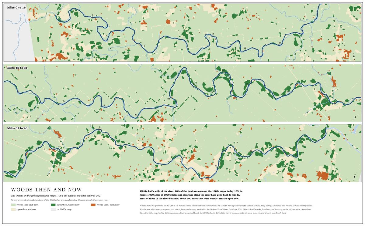
Fire kept them open. Lightning starts very few fires in the Ozarks, where the air is humid, fuels are damp and dry lightning storms are rare; of the wildfires in the Current River country in 1970–89, less than 1 percentSmith, Swanson and Leis 2008, 5. started from lightning. Nearly all the fires that shaped these woods were set by people.
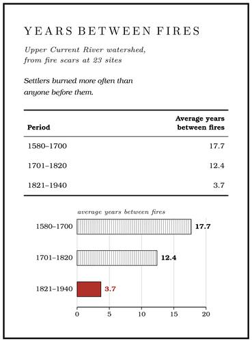
Trees keep the record. A low fire running through a pine woods can burn a scar into the base of a tree without killing it, and the tree grows over the wound and seals the scar into that year’s ring. Each ring can be given its calendar year, because a tree lays down a wide ringthe general method of cross-dating. in a good growing year and a narrow one in a dry year, and every tree in a district shares the same run of wide and narrow. Matching that run between living trees, whose outer ring is the present year, and old stumps and snags dates the rings of the dead wood, and with them its scars. On a hillside of about 160 acres near the Alley Spring campground, every shortleaf pine and white oak more than about a foot through was cored, 44 pines and 39 oaks, and 19 Section. A square mile of 640 acres, one thirty-sixth of a township. A quarter section is 160 acres (Chapter 5). Glossary → were cut from old pine stumps and snags, with nineKing and Muzika 2014, 79–81 (all overstory trees over 30 centimeters in diameter in the 64 hectares; the nine further sections from the Missouri Tree-Ring Laboratory; 80 percent of the 25 remnant samples scarred, with 1 to 9 scars each). more from an earlier collection. The oldest living pine had begun growing in 1778 and the oldest white oak in 1730, and two old pine sections went back to 1624. Four of every five old pine samples carried at least one scar, and the most scarred carried nine. The scars dated 39 fires between 1706 and 1915King and Muzika 2014, 79, 81, 84. (for the fire of 1753see Chapter 4, which tells it with the Osage., see Chapter 4), about one every five and a half years, with the longest gap twelve years and fires in back-to-back years in 1886 and 1887. A fire of 1845 scarred about a fifth of the pines, probably as settlers cleared and burned land for farms. The last scar is from 1915.
Fire scar. A healed wound in a tree’s growth rings left by a ground fire. Scars on old pines near Alley Spring record 39 fires between 1706 and 1915 (Chapter 16). Glossary → at 23 sites in the upper Current River watershed show the same change in pace (Table 16.4). Settlers burned more often than anyone before them, to green up the range and clear land (Chapter 5).
Missouri had no organized fire protection until 1925, and it lapsed again from 1931 until 1938Smith, Swanson and Leis 2008, 8–9., when the Department of Conservation set up under the constitutional amendment of 1936 (Chapter 9) was organized. As fire protection took hold, young trees filled the open woods, dense stands of pole-sized treesSmith, Swanson and Leis 2008, 9. shaded the ground, and the grasses and flowers under them dwindled. The timber boom had already taken most of the old pine (Chapter 7). The logging Tram, tramway. A light logging railroad laid up a hollow, such as Cordz-Fisher’s line down Pine Hollow (Chapter 7). Glossary → never reached the Alley hillside, but its trees record a disturbance in the 1930s, probably logging, and most of the young shortleaf pine at Alley Spring today began growing between 1930 and 1955King and Muzika 2014, 84–85 (the 1930s disturbance “likely reflects logging of the site”).. Fewer than one in fiveKing and Muzika 2014, 81 (17 percent of living trees predate 1850). of the hillside’s living trees had begun growing before 1850.
The Park Service now sets fires on purpose. Its fire plans of 1994 and 2000 aim to keep the glades open and restore the old open Woodland. The period of prehistory from about 600 B.C. to A.D. 900 in radiocarbon years, when people here first made pottery and took up the bow (Chapter 3). Glossary →. The burns have mostly been set in early spring and have often been of low intensity. On the park’s 53 monitoring plots they cut the number of saplings by more than half in two woodland types. Wildflowers and grasses have been slower to return, probably because the big canopy treesSmith, Swanson and Leis 2008, 8–11 (table 4: 54 and 59 percent; the park’s fire managers link the slow return to the survival of the canopy trees)., which survive the low burns, still shade the ground. In 2008 the park was looking into burns later in the spring and in summer, which may kill more of the big treesSmith, Swanson and Leis 2008, 11 (growing-season burns “have potential to affect canopy species mortality”)..
Birds and the bars
A float through the upper canyon in spring passes great blue and green herons in the shallows, belted kingfishers rattling ahead from bend to bend, pileated woodpeckers in the timber and wood ducks in the slower water. The northern parula, Louisiana waterthrush, eastern phoebe, yellow-throated warbler and red-shouldered hawk live in the canyon, and the cerulean warblerMDC, Jacks Fork Natural Area. has been found in the Jacks Fork Natural Area. On wet gravel at the water’s edge, sulphur butterflies gather to drink, and zebra swallowtails drift along the bars. In the clear pools turtles walk the bottom and longnose garDufur 2013, 18–19. cruise.
Fur-bearers
By one account of about 1980, beavers and other fur-bearers had disappeared from the rivers and then come backLewis 1980, PDF p. 63 (photograph caption: “Beavers and other fur’bearers disappeared from the rivers but have made a remarkable comeback”).. Beavers were gone by the early 1900s, and by the same account they were released along the river in 1933 and were abundant again by 1980. Around 1980 the stream out of Lost Hollow, below Muck Forty, ran several feet deep in places behind a string of beaver damsLewis 1980, PDF p. 30; see Reach E. (Reach E). Otters came back more slowly. By one account an otter was trapped in the Boiler Hole below Alley in December 1904 and its fur soldsee Reach I (Lewis 1980, PDF p. 54). (Reach I), and a count of 1934 found four otters on the Jacks Fork and the Current. In 1980 the state’s biologists estimated that only 35 to 70 otters survived in the remnant swamps of the Bootheel, and on the Jacks Fork an otter was only rarely reportedLewis 1980, PDF p. 75, the only source (“A survey by Bennett and Nagel in 1934 listed 4 otters on Jack’s Fork and Current River. Beavers disappeared in the early 1900’s. They were released along the river in 1933 and are now abundant”; “A rare otter is reported”).. Beginning in 1982 the state released 845 otters, the first of them from Louisiana, into 43 streams in 35 counties over eleven years, and the state’s otters later numbered more than 15,000. By the 1990s otters were working the shallow pools of headwater creeks in the central Ozarks often enough to anger anglers and pond owners, and the state held its first regulated otter-trapping season in 1996Hamilton 2007 (“In 1980, we estimated that only 35 to 70 otters survived in the few remnant swamps and wetlands in Missouri’s Bootheel region”; the releases are not said to have included the Jacks Fork)..
Newcomers
The Jacks Fork has a few invaders. The Asian clam, a small ridged clam that is not a native mussel, was already present by 1982 and turned up alive or as shells at 16 of the 28McMurray and Faiman 2023, 11, 14. mussel sites in 2017–19. WatercressBowles and others 2011, 11. grows in the spring branches.
What the living river needs
The river’s animals ask for much the same things. Sculpins, darters, madtoms and smallmouth spawn on clean gravel and rock. Mussels need a bed that stays put long enough for a juvenile to grow. Hellbenders need large, undisturbed rocks and cold water. Crayfish need slow margins and backwaters, and the insects need riffles that are not buried in silt. Nearly all of them need the cold, steady water that springs supply and the leaves that wooded banks drop in.
By the standard measures the Jacks Fork is in good health: its insects are pollution-sensitive and its fish communities score good to excellent. Its mussels and its hellbenders, the slowest-living animals in the river, have declined steeply over the last forty years, for reasons that have not been pinned down. What keeps the water clean is the subject of Chapter 17.