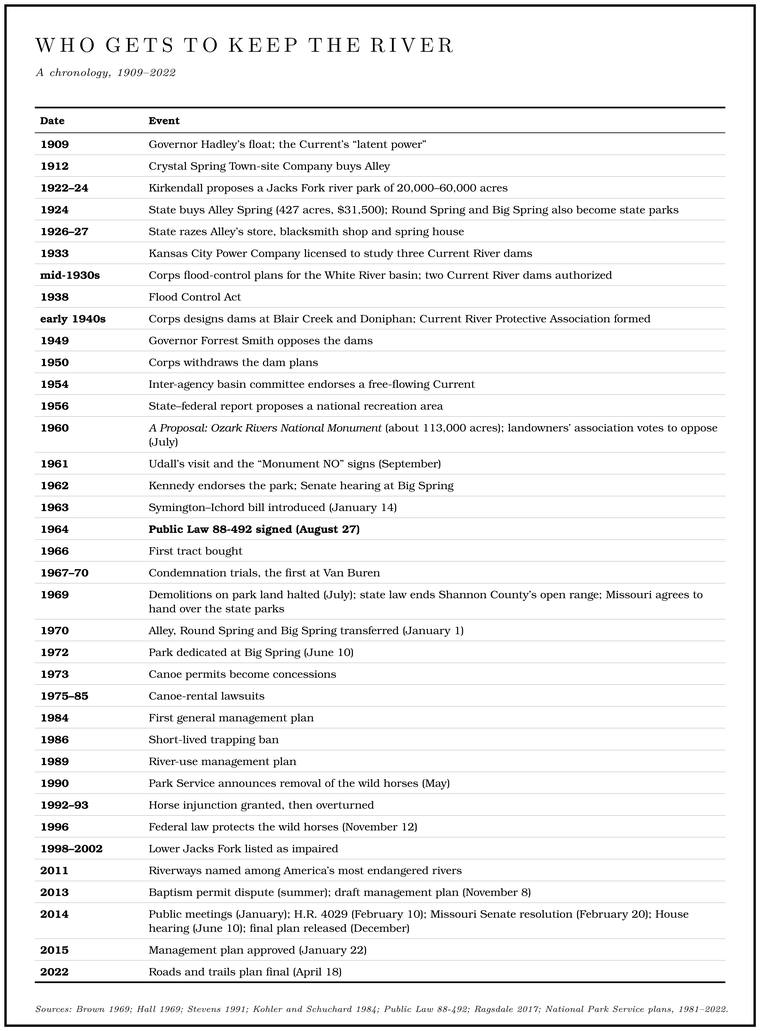
In September 1961 the Secretary of the Interior, Stewart Udall, came to see the Ozark rivers for himself. Along his two-day route he counted perhaps fifty signs nailed to trees, white boards lettered in black: “Monument NO.” From the air he could read the same words laid out in Limestone. Calcium carbonate rock formed from lime mud and shells on a sea floor. Most of the limestone laid down here later became dolomite (Chapter 1). Glossary →, letters five feet high stretching a quarter of a mile. He went home and recommendedKohler and Schuchard 1984, 110. that the rivers become a national park.
For most of their history nobody had needed to ask who the Jacks Fork belonged to. The bank belonged to whoever had bought it, homesteaded it or lived on it longest, the stock drank from it under the Open range. The old rule that a farmer fenced his crops in and let his animals run on all unfenced land; also called free range. Shannon County kept it the longest in Missouri, until a state law of 1969 (Chapter 5). Glossary → (Chapter 5), and anyone who could put a boat on the water could float it. Over the twentieth century three claimants came for the river in turn: the State of Missouri, with a park at Alley Spring in the 1920s; the Army Corps of Engineers, with plans for dams; and the National Park Service, which wanted the rivers kept free-flowing and open to the whole country. Behind all of them stood the families who lived along the water and had their own idea of whose river it was. The arrangement that came out of their argument, a ribbon of federal park along most of the river with private land, Scenic easement. A right bought by the government that leaves an owner the land, the house and the right to farm and gives up the right to develop. The law of 1964 used them along the Riverways (Chapter 10). Glossary → and state conservation land woven through it, was settled in the 1960s and has been argued over ever since.
A park for a spring
The first plan to protect the Jacks Fork as a river came from the upper river, and it lost. The Shannon County Hunting and Fishing Club, whose members had built cabins near Ebb and Flow SpringStevens 1991, 151–52; NPS, “Rymers Ranch History.” after 1912 (Chapter 9), wanted the river itself conservedStevens 1991, 178, after Flanders., and in 1922 a Birch Tree dentist named H. Kirkendall wrote to Governor Arthur M. Hyde for the club. As much as 45,000 to 60,000 acres, he said, could be assembled along the Jacks Fork for a park. The governor answered that the legislature was not readyStevens 1991, 178..
Missouri was moving toward parks all the same. A state park program was created in 1919, and in 1924 the State Game and Fish Commission began buying land for it. The commission paid for the parks out of hunting and fishing license fees, a quarter of them by the early 1930s, and at first ran them mainly as game refuges and fish hatcheries for sportsmen, with the vacationer secondStevens 1991, 190–91.. The first eight state parks were all in the Ozarks, and three of them, Big Spring, Round Spring and Alley Spring, stood on the Current and the Jacks Fork. Round Spring had the backing of two Eminence men in the legislature, Representative David Bales and Senator S. A. CunninghamStevens 1991, 177..
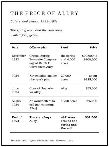
When a commission to choose park sites was set up in 1924, Kirkendall tried again with a smaller plan: 20,000 acres for about $125,000. That August he reported that an owner of 4,700 acres would sell for $25,000, not counting Alley, which would cost more per acre, and he warned that a lumber company was looking at the property. Until June 1924 he had not known that the state was also negotiating with Alley’s owners. The Crystal Spring Town-site Company of Kansas City had owned Alley since 1912, and in December 1922 its agent, Ralph E. Carr of Eminence, had offered the spring and 4,000 acres for $90,000 to $100,000. By June 1924 the company’s head, Conrad Hug, was asking $35,000 for Alley, and by the end of the year the price had come down to $31,500 for 427 acresStevens 1991, 178–79, citing the Alley Spring files of the Missouri Department of Natural Resources and Flanders and Morrow 1985, 74–80; Perry [1978], sec. 8, 2. around the spring and the mill. That came to about $74 an acre, against a little over $5 an acrearithmetic from the figures above ($31,500 for 427 acres; $25,000 for 4,700). for the 4,700 acres Kirkendall had found.
The choice favored one idea of a park over another. Representative Bales and Senator Carter Buford of Reynolds County wanted parks built around the great springs, and the state’s report for 1925Stevens 1991, 179, after Flanders and Morrow 1985, whose reading this is. praised Alley for its camping, fishing and picnicking. The Birch Tree group had wanted a long strip of river protected for its own sake. The spring won, and the river idea waited Forty. Forty acres, a quarter of a quarter section. A hill farm was often one or two forties (Chapter 5). Glossary → years.
The state then made Alley look the way it thought a park should look. In 1926 and 1927 it tore down the hamlet’s old general store, blacksmith shop and spring house, which in the words of the game commissioner’s annual report had “greatly marred the splendor of the spring and Spring branch. The stream that runs from a spring to the river, such as the branch below Alley Spring (Reach H). Glossary →,” and put up a new store of rustic native pine, a gravel road and a bridgeStevens 1991, 182, quoting the Annual Report of the State Game and Fish Commissioner for 1926 and 1927; Perry [1978], sec. 8, 2.. The Civilian Conservation Corps came in 1933 (Chapter 9; Reach H). The four state parks on the two rivers, Alley, Round Spring, Big Spring and Montauk, were counted in visitor-days, the number of visitors in a park on each day added up over the year, and between 1950 and 1958 their busiest year was 1953, with 595,122NPS 1960, 73–74 (the peak year, 1953; “The number of visitor days is equivalent to the number of tourists each day at a given park”)..
The dam builders
Other people looked at the same water and saw power. In 1909Brown 1969, 41–42. a St. Louis newspaper’s account of Governor Herbert Hadley’s float on the Current spoke of the river’s “latent power.” The Crystal Spring company planned to make electricity at Alley in 1912, and in 1918 a private firm made the first engineering surveys along the Current. Neither came to anything. A private company that wanted to dam a river for power needed a license from the Federal Power Commission, and after the Lake of the Ozarks was built on the Osagegeneral. for hydroelectric power in 1929–31, Senator Bales grew uneasy about how freely the commission handed them out. In 1933 the commission licensed the Kansas City Power Company to study three dams on the Current, at Blair Creek, above Van Buren and above Doniphan. Bales sponsored a bill to give the state a say in such licenses, which did little, and in the end the Depression stopped the company, which the commission turned down for lack of financingStevens 1991, 197–98 (“The measure had little impact on restricting the licensing procedure”)..
The larger threat came from the federal government. In the mid-1930s the Corps of Engineers drew up flood-control plans for the White River basin, and Congress authorized the Corps to build dams across Missouri, some thirty high dams by one count and fifty by anotherHall 1969, 245 (“some thirty ‘high dams’ on the rivers of Missouri”); Stevens 1991, 198 (Congress “authorized the Corps of Engineers to develop fifty dams in the state”).. The Flood Control Act of 1938 opened nearly any free-flowing streamRagsdale 2017, 22. in the country to a flood-control reservoir. In time the St. Francis, the Black, the North Fork and the WhiteHall 1969, 245. were all dammed. The Corps’ Little Rock District identified at least seven possible dam sitesBlevins 2021, ch. 6. on the Current. Two dams on the Current were authorizedHall 1969, 246; Brown 1969, 41. in the original plan, and after the Corps finished Wappapello Dam on the St. Francis in 1941, engineers from Little Rock designed them: a 107-foot dam at Blair Creek and a larger one at DoniphanStevens 1991, 199.. Blair Creek enters the Current less than five miles belowMDC, Current River float guide (Blair Creek at mile 56.2, Two Rivers at 51.5). the mouth of the Jacks Fork (Map 10.1). No dam site in any of the plans stood on the Jacks Fork itself.
The war stopped the work, and by the time the Corps returned to it the opposition had organized. Its gathering place was the Rose Cliff Hotel at Van Buren, built in 1927–29 by a Birch Tree doctor, where foresters, scientists, newspapermen and conservationists met and where Hall wroteStevens 1991, 198–99, after Morrow 1982 (“Rose Cliff Hotel”). part of Stars Upstream. A Current River Protective Association was formed shortly after 1940Hall 1969, 246., and the Missouri Farmers Association, the Conservation Federation and the state Conservation Commission joined the fight. At meeting after meeting the dams’ opponents made their case on the Corps’ own grounds. A reservoir controls a flood by holding back the water that falls above it, and the Current drains only a small corner of the White River basin, so dams on it would have lowered flood crests on the White by an amount nobody could measure and on the Mississippi not at all. A hydroelectric plant earns its keep by running steadily, and the Current’s flow was too small for steady power. The third argument was the gravel. A reservoir is still water, and still water drops whatever a river carriesgeneral.. The gravel and silt washing off the Cutover. Land from which the timber has been cut. The lumber companies left much of the Jacks Fork country cutover by about 1920 (Chapter 7). Glossary → hills would settle in the lakes and build up at their heads, and the silting would spread far above themHall 1969, 246 (the opponents showed “that the proposed structures would affect flood levels on White River imperceptibly and on the Mississippi not at all; that the stream flow was insufficient to furnish an economical source of steady electrical power; that existing gravel erosion would result in disastrous siltation not only in the reservoirs but far upstream”); Stevens 1991, 200 (“the soil erosion in the cut-over timber lands would fill the reservoir with silt”).. Even inside the Corps there was dissent: General John Kingman, a senior engineer in Washington whose cousin kept a cabin on the Current, came out against the projects. In 1949 Governor Forrest Smith put the state on record:
There are streams with natural attributes which, in their total, are so unique as to warrant the preservation of the streams, simply because they are unique.
The Corps withdrew its plans in 1950Stevens 1991, 199–200.. In 1954 the federal Arkansas-White-Red Basins Inter-Agency Committee adopted the Missouri governor’s resolution “that in lieu of reservoir development, Current River be kept as a free-flowing stream and developed as a recreational area through co-operative state and federal action.” As late as 1958Hall 1969, 247. Congress had not formally deauthorized the dams, and that summer a group of promoters began circulating petitions again, “claiming vast benefits from imaginary low-cost power and an influx of giant industries,” as one opponent described themHall 1969, 247.. The legislature answered in 1959 with a resolutionStevens 1991, 200; Kohler and Schuchard 1984, 108. asking Congress for a national recreation area. Decades later a Carter County woman recalled what the influential people who went to Washington for the park had said at the time: without it, “they would have dammed”Gibson 2000, 96. the river.
Along the Jacks Fork the dams lived on mostly as talk. A Shannon County man who was a boy in the early 1940s, when the Corps’ surveyors were at the Blair Creek site, remembered stories that the water would stand thirty feet deep over the courthouse yard in Eminence. As a child he thought the dam could go up overnight and flood them all, though as a grown man he doubted it would have covered the town. Senator Bales, he remembered, fought the dams in the legislatureDix 1998, 7–8 (David Dix, born 1932; he “just thought they could build that thing overnight and we’d all be flooded”), the only source for the story.. The owner of the Trail ride. An organized gathering of hundreds or thousands of horseback riders, camping for several days and riding the trails and river crossings. The trail rides grew into a large business on the lower Jacks Fork (Chapter 11). Glossary → at Eminence, raised on his family’s land there, remembered his grandfather and his father talking about the dams that would have flooded the placeSmith 1998, 1 (James D. Smith)..
The national idea
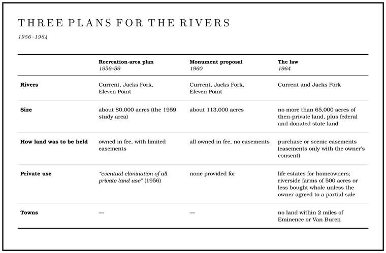
A Joint. A crack along which rock has split without moving. In the riverways the main sets run north-south and east-northeast (Chapter 1). Glossary → state and federal study in 1956 called for a national recreation area on the Current, the Jacks Fork and the Eleven Point. It also called for the “eventual elimination of all private land use” along the rivers, and the Park Service quickly lost the supportStevens 1991, 201. of most of the landowners along the Current. In 1959 Missouri’s senators, Thomas Hennings and Stuart SymingtonStevens 1991, 200., brought state and federal officials together, President EisenhowerKohler and Schuchard 1984, 108. signed a bill paying for a study, and in January 1960 the Park Service published A Proposal: Ozark Rivers National Monument. The monument would follow the three rivers for 190 miles in a corridor a mile or less wide, about 113,000 acres in all, and every acre would be bought outrightNPS 1960, 44.. The report called the rivers “clean, strong and alive.”
The proposal came with a study of what it would do to the people who lived there, by agricultural economists at the University of Missouri. On the roughly 80,000 acres they examined, about 85 percent was timber, 11 percent crops and 4 percent pasture, and more than three-quarters of it lay in Shannon County. In 1958 the whole tract paid $32,272 in property tax, about forty cents an acre. In 1955 about a third of the farm households in the area lived on less than $1,000 a year. The economists expected tourist spendingNPS 1960, 44–45, 58–60, 64, 66, 98–99. to more than make up the lost tax, and the planners forecast that by 1965 the Jacks Fork Section. A square mile of 640 acres, one thirty-sixth of a township. A quarter section is 160 acres (Chapter 5). Glossary → alone, with Alley, would Draw. A valley, in the usage of the Eleven Point side of the divide in Howell County (Chapter 18). Glossary → about 155,000 visitor-daysNPS 1960, 73 (table XIX, the Jacks Fork section with Alley Spring State Park). a year. The economists also described a society of close kin and old neighborhoods in which a home place mattered more than money:
To offer them money to move out or to sell their places, even at fancy prices, might have little attraction.
They recommended that owners be allowed to stay on for life, that local people be hired and helped to own the new tourist businesses, and that bringing in outside capital to build hotels and motels “would be a grave error.”
The fight split the river country, though not neatly between local people and outsiders. Landowners formed the Current–Eleven Point Rivers Association, which in July 1960 voted to oppose the monument. They argued that there would not be money enough to pay fair prices, that the land would be taken out of both production and taxation, and that the tourists would threaten Ozark ways. Many feared that the government would take only the good bottomland and leave them the cherty slopes. Behind the arguments there were probably long memories of Bushwhacker. In the hills during the Civil War, an irregular fighter of any side who struck from the brush and then scattered (Chapter 6). Glossary →, lumber companies and the first years of the national forests (Chapters 6 and 7). A longtime pastorKohler and Schuchard 1984, 108–9 (the memories are Kohler’s reading). in the river country wrote that he saw no moral justification for displacing some people to satisfy the recreation of others. The association’s chief spokesman was Leo Drey of St. Louis, a conservation-minded timberman whose Pioneer Forest held some thirty-five miles of frontage on the Current and the Jacks Fork. Drey had bought his first Ozark land in 1951, and in 1953 or 1954 he bought nearly 90,000 acres in Shannon and Reynolds counties from the National Distillers Products Company of New York, which had got most of it from the barrel maker Pioneer Cooperage; it was then the largest land purchase in Missouri’s historyLow 2015 (in 1953 the National Distillers Products Company “decided to sell its Ozarks holdings,” “nearly 90,000 forested acres in Shannon and Reynolds counties”; “Drey’s purchase of the land was the largest in Missouri history”); Drey 1998, 3 (“1951, I bought the first land. And this was 1954, I guess, that I got the National Distillers property”; 89,900 acres, most of it from Pioneer Cooperage). The two dates are given as the sources give them.. He cut his timber by single-tree selection, taking scattered trees and never clear-cuttingDuffy 2015., and by his own account his crews had never cut within sight of the riversDrey 1998, 8 (“we had never cut [timber] within sight of the rivers”).. Drey feared that mass recreation would ruin the solitude of the upper rivers, and he wanted the Forest Service in charge, using scenic easementsRagsdale 2017, 23–24; Blevins 2021, ch. 6; Drey 1998, 8 (“over thirty-four, thirty-five miles of river frontage on the Current and Jacks Fork”). instead of purchase. As he saw it, the Park Service drew families with young children, and on rivers where somebody drowned almost every year he preferred the outdoorsmen and fishermen the Forest Service drew. Landowners who agreed with him signed letters of intentDrey 1998, 11, 13, 14 (the Forest Service’s visitors “more outdoorsmen, fishermen,” the Park Service’s appeal “often to families with young children”; “Almost every year someone drowns in the Current”; “something like 300” letters of intent), his own account. backing the easement plan. The county officials at Eminence and Van Buren opposed the plan because they feared losing the tax baseStevens 1991, 201..
On the other side stood conservation leaders, the governor, the mayors and chambers of commerce of Eminence and Van Buren, and an association of small-town businessmen organized by Hall, the Ozark National Rivers Association, led by G. L. DavisStevens 1991, 200–201 and n. 67. of Birch Tree, who hoped for an economic boost in one of the poorest corners of the country. Hall, writing in the St. Louis papers, warned in 1960 that without a plan the region might sink into “a permanent rural slum,” and the Post-Dispatch called it “just about the last outpost of true Wilderness. Federal land designated by law to be kept without roads or development. About 4,000 acres around Jam Up Cave were studied for it in 1981 and judged unsuitable (Chapter 10). Glossary →, not only in the Ozarks, but in the whole Midwest.” The most influential leaders of both camps, Hall and Drey, were St. LouisansBlevins 2021, ch. 6, the only source for the observation (which calls the group the Ozark Rivers National Monument Association). and friends, and the fight over the rivers cooled their friendship for yearsDrey 1998, 16–17 (“Len and I, I’m afraid, parted company on this particular issue”; the fight “kind of cooled our friendship for many years”)..
Congress took four years. Representative Thomas Curtis’s bill would have given the monument to the Forest Service; Representative Richard IchordBlevins 2021, ch. 6.’s, in whose district the rivers lay, would have given it to the Park Service. Ichord had first joined the opposition, reportedly saying he was “opposed to setting aside a large part of my districtKohler and Schuchard 1984, 109. to make a habitat for bobcats and hoot owls.” After he changed sides, opponents hanged him in effigy and gave him a mock funeral on the court squareBlevins 2021, ch. 6. in Eminence. The September 1961 visit by Udall and the Park Service’s George Hartzog, hosted by Hall, Ichord and Governor John DaltonBlevins 2021, ch. 6., turned the tide. In March 1962 President Kennedy named the Ozark rivers among nine new parks he wanted, and that June a Senate subcommittee floated the river and held a hearing at Big SpringStevens 1991, 201–2. that drew heated denunciations. “We live in this particular areaRagsdale 2017, 28, quoting Sarvis 2000, 12–13. because we want to,” one witness told the House in 1963, “not because we do not have bus fare to leave.”
The bill Symington and Ichord introduced on January 14, 1963Kohler and Schuchard 1984, 110., answered the critics on several counts. It allowed scenic easements, so that a family could keep its land and sell only the right to develop it. An easement is a right in land that belongs to someone else. A scenic easement, bought for cash, commits the land against new development, while the family keeps the title, the house and the customary uses, and the land stays productive and on the county’s tax rolls. Such easements were still new in 1964, and land trusts and governments did not take them up routinely until the early 1980sRagsdale 2017, 30–31 (the easement “can preclude new development or inconsistent uses on the burdened tract, yet leave the private owner free to hold title, to continue living on the land, and to continue the customary activities,” and “the property remains productive and taxable”); the definition of an easement is general.. The bill allowed hunting and fishing under state law. It required that a riverside farm of 500 acres or less be bought whole unless the owner agreed to sell only part, so that no family would lose only its bottomland. Payments to the countiesKohler and Schuchard 1984, 109–10; Stevens 1991, 202–3. in place of lost taxes were also promised, though they did not appear in the final lawPublic Law 88-492, sec. 2.. It also dropped the lower Current in Ripley County, home to the best farms and the most solid opposition, and the Eleven Point, which went into the national Wild and Scenic Rivers system in 1968Blevins 2021, ch. 6; Stevens 1991, 203. under the Forest Service.
The law of 1964
Congress passed the bill in August 1964, and President Lyndon Johnson signed it on August 27. Public Law 88-492 created the Ozark National Scenic Riverways, the first national park area built around a river systemPublic Law 88-492; U.S. House 2014 (H. Rept. 113-594)., four years beforeKohler and Schuchard 1984, 110. the Wild and Scenic Rivers Act. Its purpose clause names what the nation meant to keep: “unique scenic and other natural values and objects of historic interest,” the two rivers “as free-flowing streams,” the springs and caves, the wildlife, and the use and enjoyment of all of it “by the people of the United States.”
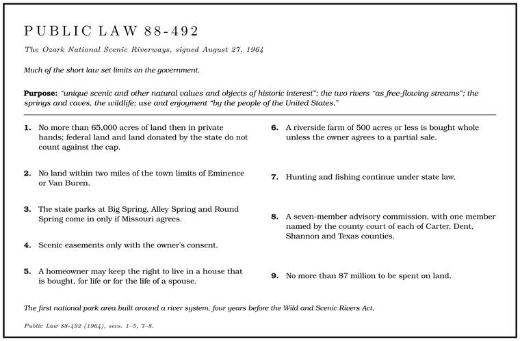
Much of the short law set limits on the government. The park could take in no more than 65,000 acres of land then in private hands, and federal land and land donated by the state did not count against the cap. Scenic easements did not count eitherRagsdale 2017, 26, after Sarvis 2000., since the government bought only a right in the land and the owner kept the land itself. No land could be included within two miles of the town limits of Eminence or Van Buren. The state parks at Big Spring, Alley Spring and Round Spring would come in only if Missouri agreed. Scenic easements could be bought only with the owner’s consent. A homeowner whose house was bought could keep the right to live in it for life, or for the life of a spouse, and was paid the property’s market value less the value of the right kept. The park itself would exist only when the Secretary of the Interior judged that enough land had been bought to run it and announced it in the Federal Register. Hunting and fishing would continue under state law. A seven-member advisory commission, set to expire ten years after the park was established, would include one member named by the county court of each of the four counties, Carter, Dent, Shannon and Texas, two named by the governor and one by the SecretaryPublic Law 88-492, secs. 3, 4, 7., and no more than $7 millionPublic Law 88-492, secs. 1–5, 7–8. could be spent on land. Leonard Hall chaired the advisory commission for a time and was removed from it in 1969; he counted the fight for the rivers the high point of his conservation workHall Papers, biographical sketch (chairman; the “high point” of his conservation work) and shelf list, folder 17 (“LH removed from Advisory Commission, 1969”).. The Life estate. A right to go on living in a house for life after selling the land to the government, offered to homeowners under the law of 1964 (Chapter 10). Glossary → followedNPS 1960, 98–99. the University of Missouri’s advice, and the easements were the ones Drey and the Forest Service had argued for. The Eminence exclusion kept the county seat out of federal hands and left a gap in the middle of the park.
On the Jacks Fork the boundary meets the river in the long bends about 4.2 miles below the Prongs, nearly three miles above Buck Hollow, the Highway 17 crossing. The park calls this upper end Buck Hollow, and it is the westernmost extent of the whole Riverways, where the park reaches into the southeastern corner of Texas County, about five and a half milesNPS 2013, 17 (“The westernmost extent of Ozark National Scenic Riverways, known as Buck Hollow”). from Mountain View. The first four milesErwin, Jacobson and Jones 2021, PDF 44 (figures 34–35, distances counted downstream from the park boundary); Erwin 2021 (address point 0, about 37.0637, −91.6992); measured along the river centerline traced for the maps in this book; see Reach C. of the river below the Prongs, and the Prongs themselves, were left in private hands, and they still are (Map 10.1). From there the park followed the river down past Alley, broke around the ring of town and private land at Eminence, and ran on to the Current at Two Rivers.
Buying the river
Owners had three choices, at least on paper. They could sell outright, keeping a life estate in their home if they wished. They could sell a scenic easement, keeping the land, the house and the right to farm but giving up the right to develop it. Or they could refuse, and the government could take the land by Condemnation. The taking of private land for public use by court order, with payment at fair market value. Some land for the Riverways was taken this way in trials from 1967 to 1970 (Chapter 10). Glossary →. The Fifth Amendment allows the government to take private property for public use only with just compensation, which the courts measure as fair market value, the price a willing buyer would pay a willing sellergeneral., and when owner and government could not agree, a federal court decided it. The first tract was bought in 1966, and a year later the land office at Eminence had acquired 7,600 acresKohler and Schuchard 1984, 110.. The park’s second superintendent, who served in 1966–67Hennesay 1998, 4, 8–9 (Vernon Hennesay)., remembered Eminence as “kind of the center of the opposition,” though he added that “there was quite a bit of support in Eminence, too.”
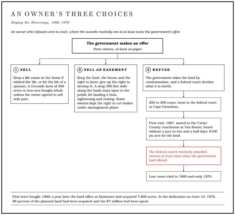
Owners who could not agree on a price went to court, in two hundred to three hundred cases, most of them in the federal court at Cape Girardeau. As one of the owners’ lawyers remembered it, every landowner’s first question was how to stop the project, and the answer was always that the only remedy was the highest possible price. That lawyer, Stephen Limbaugh of Cape Girardeau, tried about thirty-five of the cases and later sat as a federal judge in the same court. The first cases came to trial in 1967. The two judges, James Meredith and Roy Harper, persuaded many lawyers to waive juries to save time. To calm the river country, Judge Meredith moved the first trial from Cape Girardeau to the Carter County courthouse at Van Buren, heard it without a jury in two and a half days, and awarded one hundred dollars an acre for the land, with small sums for a log house and the timber. Then he left the courthouse with three United States marshals and drove back to Cape Girardeau. Many owners settled after that ruling. Most later cases went to juries, whose awards ranged widely depending on whether they believed the owners’ appraisers or the government’s. The last cases were tried in 1969 and early 1970Limbaugh 2013..
How land should be valued was itself in doubt. An appraiser values land at its “highest and best use,” the most profitable use the law and the ground allow, and then looks for sales of similar landthe appraisal standard (general). nearby. Neither step worked well on the river. Farming was thin on most of the tracts, comparable sales were few because river land seldom changed hands outside families, and the only other highest and best use an appraiser could argue was recreationLimbaugh 2013., for which there were almost no precedents. The money was short from the start. Seven million dollars for as much as 65,000 acres came to a little under $108 an acre, and park officials set upper limits on what their appraisers could offer, which is probably why so many cases ended in courtFlader 2011, 116 (the $7 million led “NPS officials to set upper limits on appraisals, which meant that more than 200 cases ended up in court”); the per-acre figure is arithmetic.. The government’s contract appraisals were often very low, and the federal courts routinely awarded owners at least twiceBlevins 2021, ch. 6, quoting Sarvis 2000 (the appraisals “ridiculously low”). what the government had offered. People who cooperated came to believe they had been paid less than neighbors who held out. A former Johnboat. A long, narrow, flat-bottomed, square-ended boat, poled, paddled or motored. It was the guide boat of the Eminence outfitters and is still the fishing and gigging boat of the river. The word is in print from 1894 (Chapter 9; Chapter 18). Glossary → guide in Eminence, whose wife’s family lost about three hundred acres and their house below Two Rivers, remembered an appraiser who said he enjoyed “trying to see how cheap I can get this land,” and another owner’s place on the Current priced against a falling-down house up on the Jacks ForkDix 1998, 13–16, the only source.. A Carter County man born on his family’s riverfront farm remembered the government man who came to the house about 1965 with an offer, and his father’s answer:
And dad, he let them condemn us, and took them to court, and of course he got more money.
Many also said the money would not buy a comparable farm outside the boundary, because the Bottom. The flat land along a river or creek, built of its deposits and open to its floods. In the 1920s the bottoms near Eminence averaged about a quarter of a mile wide (Chapter 2; Chapter 5). Glossary → taken were the best landGibson 2000, 96–99. in the county.
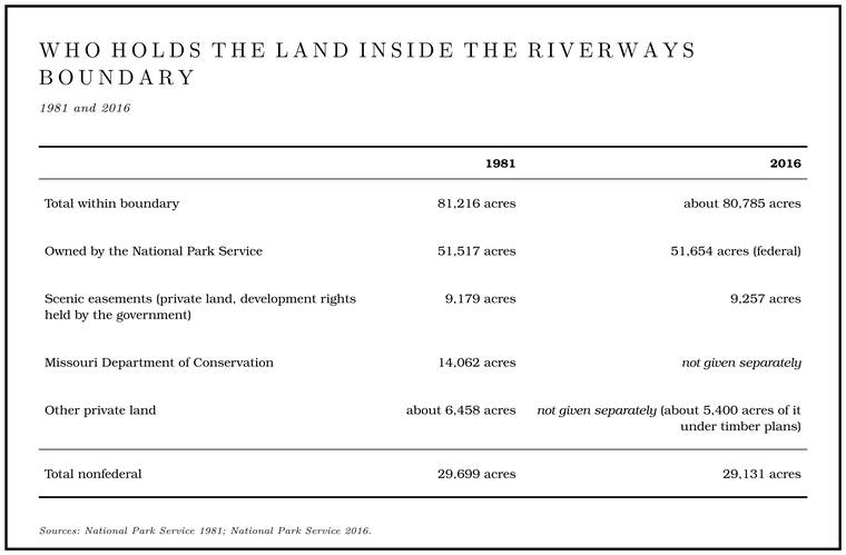
Scenic easements did much of the work. The owners of riverside cabins who lived in the cities had been expected to sell and keep a life tenancy, and instead they were offered easements, took them and kept their cabins with no end dateFlader 2011, 117 (“the more urban owners of riverside cabins, who had been expected to sell with life tenancy, instead were offered and opted for easements with essentially perpetual tenancy”).. By 1981 the boundary enclosed 81,216 acres. The Park Service owned 51,517 outright and held scenic easements on 9,179 more, the Missouri Department of Conservation held 14,062, and about 6,458NPS 1981, 1, 32–33. remained in ordinary private hands. An easement kept a strip 300 feetNPS 2016, 11. wide along the bank open to the public for landing a boat, sightseeing and resting, and some easement owners kept the right to cut timberNPS 1981, 44. under management plans. Missouri agreed in 1969 to hand over the three state parks, and they were transferred on January 1, 1970Kohler and Schuchard 1984, 110; Limbaugh 2013, n. 2.. When the park was dedicated at Big Spring on June 10, 1972Thornberry-Ehrlich 2016, 1., 88 percent of the planned land had been acquired and the $7 millionKohler and Schuchard 1984, 110. had been spent.
Many of the houses were lost. Between 1964 and 1969 many buildings on the new federal land were torn down, some by the Park Service, some under agreement with it, and some by people acting with or without permission, until in July 1969 the demolitions were halted so that a historical architectBrown 1969, 60, 62–63. could judge what was left. Families who had sold came back to find no trace of the house, or strangersGibson 2000, 97. living in it. At Buck Hollow most of the cabins of Cardinal Acres came down in 1966–69 while still in private hands, and in October 1969NPS 2013, 22, 24, 26. the land around the bridge passed to the United States (Chapter 9).
Why the resentment lasted
The land fight ended in the early 1970s. The feelings it left did not. In Shannon and Carter counties in the late 1990s even the park’s strongest supportersGibson 2000, 67–68, from interviews for the Park Service in Shannon and Carter counties. admitted that the first land acquisition had done harm. “Them using eminent domain the way they did when they first came in here,” one man said, “I’ll never forgive them for that.” Many people did not separate the Park Service from the Forest Service, the state or government in general, and the park, with its uniformed rangersGibson 2000, 67–68., took the brunt of all of it.
The grievances went beyond money. Residents had expected that Homestead. Public land claimed under the Homestead Act of 1862, which gave 160 acres to a settler who lived on it and farmed it for five years (Chapter 5). Glossary →, roads and cemeteries inside the boundary would be kept as they were, and instead they watched fields grow up in brush and roads close. A fifth-generation Shannon County man described the family cemetery near the old home place on the Current: once a walk of less than an hour by the county road and the Ford. A place where a road crosses through the water. Many of the river’s fords took the names of the families who lived beside them (Chapter 8). Glossary →, it became a sixty-mile round trip by four-wheel drive after the road was closed, and when he and his son finally reached it they spent a day with a chainsawGibson 2000, 100–103. clearing the graves. Another family’s cemetery on the Current was left on a one-acre parcel when the government took the rest of the farm, so that, as the former guide saw it, the agency never had to keep up the graves or the road to themDix 1998, 17–18, the only source (the Wayland Powell farm and family cemetery; “I suppose the reason they did that, then they’re not responsible for the maintenance”).. The river people saw themselves as the land’s caretakers. They had farmed, burned, grazed and fished it for more than a century, the rivers were still clear enough that the nation wanted them, and many could not see why land had to be taken for what looked to them like a recreation projectGibson 2000, 96, 98–99, 103.. The park came on the heels of the national forests and their war on woods-burning (Chapter 7), and a 1969 state law ended the open range in Shannon County, the last countyRikoon and Albee 1998, 220 n. 6. in Missouri to keep it (Chapter 5).
A whole local genre grew up of what might be called ticket storiesRikoon and Albee 1998, 215., about the man fined for moving a rock, crossing a creek or picking a flower. True or embroidered, they carried the same message. “We don’t want to be made into another Yellowstone,” one trail rider said in 1995. “We live here.” The economic recovery the park’s backers had promised probably never came. The canoe trade arrived (Chapter 9), but seasonal service jobs were no match for the remoteness of the country, and fifty years after the park was created Shannon County ranked last in Missouri in median household incomeBlevins 2021, ch. 6, whose judgment it is..
The other view was always there too, and it was often local. Eminence’s own leaders had supported the park. One resident said in the late 1990s that the park had “saved the river,” because rangers kept order among visitors that local people could never have controlled. A park man who spent some twenty-three years at the RiverwaysOutlaw 1998, preface, 17, 21, 45 (Alex Outlaw, with the park “about twenty-three years, 1972–1995”)., for a time as its chief of interpretation, remembered Eminence as “very negative” toward the park and still called it “sort of the heart of the Riverways.” The Carter County woman who remembered the dam talk said that up the river the answer had once been “No” but that the park had since been “alright” by her. Limbaugh, who had spent years fighting the government’s appraisals in court, thought in 1997 that the feeling against condemnation had dwindled and that the Park Service had done “a splendid job”Limbaugh 2013. with the rivers. Views of the park had been mixed from the start, and in the late 1990s most of the people asked still believed that it had broken old ties to the land and that some families had been treated unfairly.
Canoes, horses and horsepower
Once the land was bought, the fights moved to the water and the woods.
The canoe wars. The canoe boom (Chapter 9) brought sixteen rental businesses into the park by the late 1960s under special permits. A park Concession. A business under contract with the Park Service to serve visitors inside the park, such as the canoe rentals at Alley Spring and Two Rivers. The canoe-rental permits became concessions in 1973 (Chapter 10; Chapter 11). Glossary → is a kind of licensed monopoly. The government sets the price, the manner and the volume of the service, and in return the concessioner gets a contract for a set term, a fair chance at a profit and, as long as it performs, a preferenceRagsdale 2017, 42–43, 48 (concessions “a species of government-sponsored monopoly”). when the contract comes up for renewal. In 1973 the Park Service turned the permits into formal concessions, with franchise fees, insurance, rate limits and safety rules, and in the 1970s it placed a moratoriumNPS 1981, 60. Cases: United States v. Williams (E.D. Mo. 1975, 1976); Free Enterprise Canoe Renters Ass’n v. Watt, 711 F.2d 852 (8th Cir. 1983); Current-Jacks Fork Canoe Rental Ass’n v. Clark, 603 F. Supp. 421 (E.D. Mo. 1985). on new ones. A study of the river’s use then turned up falling water quality, more trouble for the rangers and floaters who felt crowded, and more and more renters who worked from private land outside the boundary without contracts, delivering canoes to the river on public roads. The government prosecuted one of them in 1975 under a rule against commercial outfitting without a permit and lost, because the rental contracts were made outside the park and the boats went in and out from state roads. It wrote a narrower rule, requiring a permit for delivering or picking up rented boats, prosecuted again in 1976 and lost again, the court holding that the United States had no power to stop canoe deliveries on a public road when the contract was made outside the park. The Park Service let the matter rest for a time. Rulings of the Supreme Court in 1976 and of the federal appeals court for the region in 1981 had given the Constitution’s property clause a broad reach, and with them behind it the park began enforcing the rule again. Reading those rulings to let Congress regulate what happens on land the government does not own when that is needed to protect federal land and its purposesRagsdale 2017, 46–47 (the 1975 and 1976 acquittals in United States v. Williams; then the Park Service, “emboldened by the Supreme Court ruling in Kleppe v. New Mexico, and the Eighth Circuit opinion in Minnesota v. Block,” enforced the rule again, and the district court noted that both courts had found it within Congress’s property-clause power to regulate non-federal lands “if the regulation was deemed necessary for the protection of human life, wildlife, government land or government objectives”). The cases are Kleppe v. New Mexico, 426 U.S. 529 (1976), decided in June 1976, before the second acquittal in November, and Minnesota ex rel. Alexander v. Block, 660 F.2d 1240 (8th Cir. 1981); the district court’s reading is in Free Enterprise Canoe Renters Ass’n v. Watt, 549 F. Supp. 252, 262 (E.D. Mo. 1982). Kleppe itself upheld the Wild Free-Roaming Horses and Burros Act on federal land and left open how far the clause reaches onto private land, so “a broad reach” is the measure of it here., the federal courts in 1982 and 1983 upheld the Park Service’s power to regulate every canoe rental serving the Riverways, wherever its office stood, and a 1985Ragsdale 2017, 46–48. decision protected the existing concessioners’ right of preference.
The first plans. The Riverways had no General management plan. A park’s long-range guide, setting out what each part of it is for and what may be done there. The Riverways’ first was adopted in 1984 and its second approved in 2015 (Chapter 10). Glossary → until 1984. The 1981 draft looked at making about 4,000 acres of the upper Jacks Fork around Jam Up Cave a wilderness area and judged it unsuitableNPS 1981, 30, 126.: designation would mean drastic changes in how people used the river, and its roads and utility lines would be hard to remove under the existing ownership. The Cross-Country Trail Ride had camped on more than a hundred acres of river bottom at the eastern edge of the park’s land on the Jacks Fork, reached by a county road off Highway 106, perhaps the bottom where a ride of 1974 centered, about a mile and a half below Alley SpringBarks 1978, 29 (August 11–17, 1974, “about 1.5 miles downstream from Alley Spring” and about 4 miles upstream from Eminence); that it was the same site is an inference.. Its lease expired in January 1981NPS 1981, 93 (the Horse Camp, “on the eastern edge of the riverways boundary on the Jacks Fork River,” reached by “2.5 miles of undesignated county road from Missouri 106,” “100+ acres of gently terraced river bottom land,” “the previous location of the Cross-Country Trail Ride”)., and when the Park Service offered a concession contract with new sanitation and safety requirements, the operator moved outside the park. A river-use plan in 1989Ragsdale 2017, 52; NPS 2016, 13. dealt with canoe traffic and motorboats. Over those years the park and its neighbors clashed, in one small fight after another, over trapping, which the Park Service banned briefly in 1986Blevins 2021, ch. 6., hunting with dogs, motorboat horsepower and the Outfitter. A business that rents boats to floaters and runs their shuttles (Chapter 20). Glossary →Rikoon and Albee 1998, 209..
The wild horses. The fight that defined the 1990s began with a short notice in the Eminence weekly in May 1990. The Park Service announced that it would remove a few small bands of free-roaming horses, perhaps twenty to thirty in all, that ranged over about twenty-four milesRagsdale 2017, 49. of the park along the lower Jacks Fork and the Current around Two Rivers. To the agency they were feral livestock, by its account descended from a pair turned loose in the 1950sRikoon and Albee 1998, 207., and as non-native animals they did not belong in a natural park. To many people around Eminence they were the last living piece of the open range, a link to the years when families turned their work horsesRikoon 2006, 1–2, 4; Rikoon and Albee 1998, 211. out on the ridges to winter alongside the wild bands. The superintendent of the time told the start of it another way. By his account the park had known of the horses for years and chosen to wait, until two men claiming to be inspectors for the humane society announced that they would take the horses out, and a television storySullivan 1998, 47–50 (Arthur L. Sullivan, superintendent 1976–95), the only source for this account. made the matter public.
Residents organized the Missouri Wild Horse League, and a petition drew more than 1,200 mostly local signaturesRikoon 2006, n. 6.. A Poplar Bluff lawyer who heard about the fight in a caféKennedy 1998, 1. and offered his help remembered one demonstration with an eight-mile convoy of trucks and horse trailers escorted by the Shannon County sheriff to the Riverways office at Van Buren, where about 3,000 people gathered in a town of about 900Kennedy 1998, 6–7.. At one protest, by the superintendent’s count, as many as 300 horses were ridden up to his officeSullivan 1998, 54 (“they had as many as 300 horses that rode up to my office in protest”).. A federal judge in St. Louis issued a temporary restraining order, late in 1990Rikoon and Albee 1998, 205; Rikoon 2006, 2. by one account (another dates the suit to February 1991), and on June 17, 1992, the federal court at Cape Girardeau, in the person of Judge Limbaugh, made it permanent. The park could remove the horses only if they harmed it, and the court found no evidence that about twenty horses were harming a park of nearly 70,000 acres, “one horse to 3,500 acres.” It also faulted the agency for never asking whether the horses were a cultural or historical resource, and it pointed to the federal wild horse act of 1971, which did not cover the park, as a sign of what Congress thought of wild horses.
A court reviewing an agency’s decision may set it aside only if the decision was arbitrary, ignoring the relevant facts or resting on a clear error of judgment, and on June 15, 1993Senate Report 104-312, from the Park Service’s testimony., a divided appeals court overturned the ruling, holding that the judge had named that standard and then not applied it. In the majority’s view the record showed enough harm to support removal, and if the cultural question needed answering, the case should have gone back to the agency. The dissenting judgeRagsdale 2017, 49–51 (the 1971 Wild Free-Roaming Horses and Burros Act did not apply to the park but “certainly demonstrates Congressional intent to protect wild horses”; Judge Loken dissenting in the appeals court); the standard of review is the Administrative Procedure Act’s, 5 U.S.C. § 706(2)(A); Morrow 2013, contributor note; Wilkins v. Lujan, 798 F. Supp. 557 (E.D. Mo. 1992), rev’d 995 F.2d 850 (8th Cir. 1993). thought the Park Service had made up its mind before it announced anything. More than a thousand people turned out for a protest that October. The Park Service, though free to act, left the horses aloneRikoon 2006, n. 6; Rikoon and Albee 1998, 211., and the superintendent remembered that the Supreme Court declined to hear the caseSullivan 1998, 52, his recollection, not checked against the Court’s records..
Congressman Bill Emerson carried the horses to Washington, and on November 12, 1996, they were written into federal law. The Riverways must allow a herd of no fewer horses than were living there on that date and no more than fiftyPublic Law 104-333, sec. 803; NPS 2016, 10., managed under agreement with the Wild Horse League or another nonprofit (the herd today is in Chapter 11). At the benefit shows supporters had worn caps and T-shirts reading “wild and free let ’em be.” The fight probably had less to do with animal rights than with resentment of the agency that had come to stand for condescending power from outsideBlevins 2021, ch. 6 (the controversy “owed less to animal rights activism and more to resentment toward the government agency that had become the symbol for condescending outsider power”). Ragsdale 2017, 52, dates the signing to October 3, 1996; Public Law 104-333 was approved on November 12, 1996 (sec. 803(b), 110 Stat. 4186; 16 U.S.C. § 460m-6, which counts the herd from “November 12, 1996”), and the text follows the law.. For the League’s members the horses had come to stand for themselves. “As long as the wild horses continue to roamRikoon 2006, 14 (screen page of the electronic copy).,” one of them said, “then maybe there’s hope for us as well.”
A Missouri Sagebrush Rebellion. In the American West the Sagebrush Rebellion of the late 1970s and 1980s was a movement of ranchers, miners and county governments demanding that federal lands be handed to the states. Missouri had little federal land to rebel against, because the government had sold nearly all its public domainRagsdale 2017, 1, 56. there in the 1800s and had to buy back the land for the national forests and the Riverways. The same mood took hold around the park all the same. Through the 1990s people in the surrounding counties turned back a proposed state Natural Streams Act, new hunting and trapping rules, and a plan to name the Ozarks an international biosphere reserveRikoon 2006, n. 15; Rikoon and Albee 1998, 217–18..
Horses of another kind. Meanwhile the number of saddle horses in the park grew. Riders on the lower Jacks Fork numbered a few hundred in the early 1980s and about 3,000 during the special trail-ride events of August and October 2000. A Carter County landowner on the Current, talking in 1998, described the riders near Eminence “crisscrossing back and forth over that beautiful Jacks Fork,” “crossing over and over,” and said a floater could smell it on the riverCrutcher 1998, 17–18, 46 (Joel Montgomery speaking, who owned a farm with two miles of frontage on the Current below Van Buren; the 1998 interview was a joint one).. In 2010 eighty-eight miles of unauthorized horse trails were mapped, four timesNPS 2022a, citing Chilman and Vogel 2001 and Park, Chilman and Seekamp 2011. The 3,000 are riders counted during the special events; the 3,000 horses in Chapter 17 are a different measure, the largest facility’s estimate for its rides. the official network, with many unofficial river crossings, and in 1998 the state listed the last stretch of the river, below Eminence, as impaired by bacteria, a listing still in force in 2002 and followed by a cleanup plan in 2004see Chapter 17. NPS 2022a’s “Between 1998 and 2002” dates the contamination behind the listing, not the listing itself. (Chapter 17). In 2011 the conservation group American Rivers named the Riverways one of America’s most endangered rivers, blaming motor vehicles and horses that went down to the river wherever they could. The Park Service answered that off-trail riding and driving were already illegalRagsdale 2017, 53..
The plan that lit the fuse
By the 2000s the 1984 plan was badly out of date. A general management plan is a park’s long-range guide, setting out what each part of it is for and what may be done there. Under federal environmental law the Park Service has to publish a draft with several alternatives, name the one it prefers, take public comment and answer it, and only then issue and approve a final planthe planning process under the National Environmental Policy Act (general); see NPS 2014 (GMP).. The Park Service released a draft of a new plan on November 8, 2013NPS 2014 (GMP), 391.. By then the ground had been primed. That summer a church member wrote to the superintendent about boulders that blocked vehicle access to a Gravel bar. A bank of chert gravel and sand, usually on the inside of a bend, bare at low water (Chapter 15; Chapter 18). Glossary → his congregation used, and the reply that such activities needed a special-use permit, requested two days ahead, was taken to mean that churches needed a federal permit to baptize in the river. Congressman Jason Smith of Salem protested, and the park said quickly that no permitChristian Post 2013. was needed for a baptism. Along a river where people had been baptized for generations (Chapter 19), the episode was not soon forgotten.
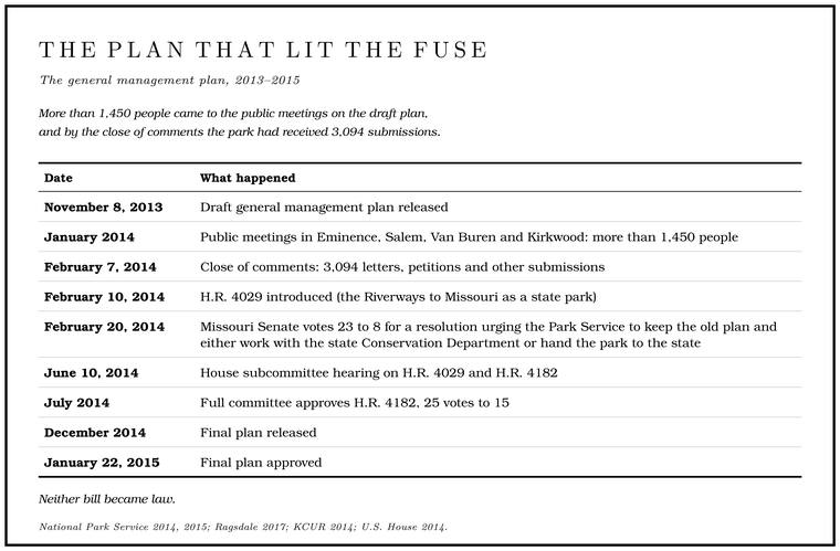
The draft’s preferred alternative proposed to close the upper Jacks Fork and the upper Current to motorboats, about a third of the two rivers, and to make another seventh motor-free in the busy season. It would cut back the roughly 100 miles of unofficial horse and foot trails, with their many river crossings, while adding about 35 miles to the 23-mileNPS 2013 (draft GMP), 125–26. network of official horse trails, with engineered crossings, and it would recommend about 3,430 acresRagsdale 2017, 54–55. near Big Spring to Congress as wilderness. The Park Service saw a plan for crowding, erosion and water quality. Many of its neighbors saw a plan to shut them out of their own river. Public meetings in Eminence, Salem, Van Buren and the St. Louis suburb of Kirkwood, postponed two weeks by winter weather, were held in January 2014, and more than 1,450 people came. By the close of comments on February 7 the park had received 3,094NPS 2014 (GMP), 384, 391–92. letters, petitions and other submissions.
The comments ran both ways. Hunters, trappers and giggers pointed out that Low Water. The local name for the Highway Y bridge over the South Prong, the access beside it and the county’s low-water crossing where the prongs meet, and so for the head of the river (Chapter 8; Chapter 18). Glossary → already kept most motors offNPS 2014 (GMP), 402–4. the upper rivers except in fall and winter, when local people gig and trap there. One trail-ride business warned that a blanket ban would end Gig, gigging. A gig is a spear of three or four barbed iron tines on a pole as much as fourteen feet long. Gigging is spearing fish with it from a boat in clear, shallow water, chiefly suckers, by night under lights or by day (Chapter 19). Glossary → there and risked “further alienating the local people and creating a problem where none currently exists.” Conservation groups said the draft did not go far enough to protect water quality and the Ozark Hellbender. A giant salamander up to nearly two feet long, flat and mottled brown, that needs cold, clean, flowing water. The Ozark hellbender was described from a Current River specimen in 1943, and by 2019 the Jacks Fork was thought to hold ten or fewer (Chapter 16). Glossary →KCUR 2014. (Chapter 16).
The politics moved faster than the paperwork. On February 10, 2014, Congressman Smith introduced H.R. 4029Ragsdale 2017, 62., which would have given the Riverways to Missouri as a state park, and promised to fight any wilderness designation “tooth and nail.” On February 20 the Missouri Senate voted 23 to 8KCUR 2014. for a resolution urging the Park Service to keep the old plan and either work with the state Conservation Department or hand the park to the state. Governor Jay Nixon took the other side. Transferring the park, he wrote to the Interior Secretary, “does not seem the most prudent step,” and Lieutenant Governor Peter Kinder called the governor’s letter “a disgrace.” The park cost about $6 million a year to run, employed about 120 people and needed an estimated $34 million in repairs, and in AprilRagsdale 2017, 63. the state Senate’s budget committee struck a $6 million line for a state takeover out of the next year’s budget. In May, on the courthouse lawn in Eminence, Kinder argued in public for turning the park over to Missouri. A member of an opposition group called Voice of the Ozarks put the case in four words: “This is our river.” Not everyone in the crowd agreed, and a man whose family lived on the Jacks Fork told a reporter that many local people would welcome more oversightRagsdale 2017, 54–55, quoting the Kansas City Star, July 26, 2014. of the park.
In Washington a House subcommittee heard the transfer bill and a second Smith bill, H.R. 4182, on June 10, 2014. The second would have frozen management under the 1984 plan, kept public river accesses open, forbidden any permit for baptisms and held motor limits where they were. The Interior Department told the subcommittee that it “strongly opposes” the transfer, which would “erode the idea of a Federal system of public lands,” and noted that the park had drawn about 1.4 million visits in 2012 and about $56 million in economic benefitsU.S. Department of the Interior 2014. for the surrounding communities. The full committee approved H.R. 4182 by 25 votes to 15U.S. House 2014 (H. Rept. 113-594). that July. Neither bill became law.
The final plan, released in December 2014NPS 2015 (GMP summary), 1, 5, 11–12; NPS 2014 (GMP), 402–4. and approved on January 22, 2015, bore the marks of the fight. The upper Jacks Fork and the upper Current would be free of motors during the busy season, April 1 through September 14. In a change made after the comments, johnboats with motors of 25 horsepower or less would be allowed on those upper reaches from the opening of the fall gigging season through the end of trapping season. “Gigging at night from johnboats,” the Park Service wrote, “is a unique Ozark cultural experience.” No stretch of either river was set aside for paddlers the year round, which drew criticismNational Parks Traveler 2015. from the other direction. The horse-trail plan and the wilderness recommendation for Big Spring went forward, and the upper Jacks Fork, with too little federal land and too many uses that do not fit a wilderness, was again left outNPS 2015 (GMP summary), 5..
Where things stand
The fight of 2014 ended without a clear winner. The 2015 plan remains the park’s guide. The roads and trails plan it called for took seven more years and was released in final form on April 18, 2022NPS 2022c (news release); NPS 2022a., sorting authorized roads, trails and fords from the ones visitors had made (Chapter 8). How the park has been run since is the subject of Chapter 11.
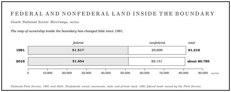
The map of ownership has changed little since 1981. In 2016 the Riverways took in about 80,785 acres, of which 51,654 were federal and 29,131 were not. Scenic easements covered 9,257 acres, and another 5,400 or so acres of private land inside the boundary were under timber plans. The easements are still argued over. Conservationists have charged that violations go unenforcedRagsdale 2017, 32., and in the park’s own planning many easement tracts may in time be suitable for purchaseNPS 2016, 3–4, 10–11, 13..
On the Jacks Fork the pattern shows at a glance (Map 10.1). From the Prongs down to the park boundary, about 4.2 miles below themErwin, Jacobson and Jones 2021, PDF 44; see Reach C., the river runs between private fields and woods, outside the park. In 1954 the Missouri Supreme Court held that a stream able to float small boats, though too small for commerce, is a public highway for travel by floating or wadingElder v. Delcour, 269 S.W.2d 17, 25–26 (Mo. 1954); the state reads that … below the high-water mark: MDC, “Trespassing”; McCarter 1995 (the court held the channel a “public highway” “for travel by floating or wading, for business or for pleasure”)., and that the public may fish it; the state reads that as a right to stay within the stream bed, below the High-water mark. The edge of a stream bed, in practice the line where trees and other permanent plants grow. The public’s right to float, wade and fish runs to it (Part Six). Glossary → (Part Six). From there to Alley it runs through federal land broken by scenic easements and private holdingsMap 10.1 sources. (Map 10.1). Around Eminence the town’s two-mile ring breaks the park in two, and below town the park runs on to Two Rivers through the bottoms where the wild horses graze.
The case of 1954, from the MeramecMcCarter 1995 (“the waters of the Meramec River are public waters”)., began when a landowner threatened a canoeist with a trespass suit for fishing from his canoe, camping on the riverbed and carrying his canoe across the bank around a log jam. The court called such a river “floatable,” a stream that ordinary commercial boats could not use but that had served the lumber trade for floating logsWashington University Law Quarterly 1955 (floatable streams “cannot be used by ordinary commercial vessels” but are “useful commercially to the lumbering industry for floating logs”; the court held the river a “floatable” stream in which the public may travel and fish)., as the Jacks Fork had floated its tiessee Chapter 7. (Chapter 7).
The springs are protected, no dam stands on either river, and the water is clear. The scars of the land fight are still there too, in family stories, in closed roads to old cemeteries and in a wariness toward anyone in a uniform. The state park, the dam builders and the 1984 management plan have all come and gone, and who gets to keep the river is still being argued.