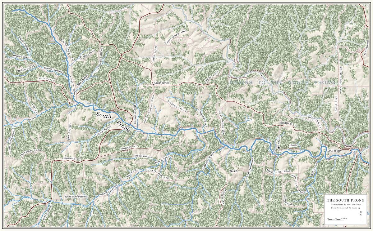
The South Prong rises on the upland of southern Texas County, east of Cabool, and runs about sixteen milesUSGS GNIS (South Prong Jacks Fork, source and mouth); O’Brien 1939, 102 (Pierce Township “in the s.e. corner of the county”); the project’s channel traced from USGS 3DEP elevation data., first south and then east, to its meeting with the North Prong a short way below the Highway Y bridge at Low Watersee Chapter 8 and Reach C.. Several of its creeks head across the line in Howell CountyPottenger 1945, Howell file pp. 7–8, 116., within a few miles of Willow Springs. Its country falls into three drainages of about thirty square miles each, the upper Prong. A branch or arm of a creek, set down in 1860 as Southern usage. The North and South Prongs join to form the Jacks Fork (Chapter 18). Glossary →, Pine Creek and the lower prong, about 88 square milesMDC 2001, PDF 21 (Figure Ge06: 30.9, 27.7 and 29.9 square miles). in all. Around 2000 roughly three-quarters of each was forest and Woodland. The period of prehistory from about 600 B.C. to A.D. 900 in radiocarbon years, when people here first made pottery and took up the bow (Chapter 3). Glossary → and most of the rest was grassMDC 2001, PDF 65 (table Lu05).. Public land was almost absent: none on the upper prong, less than a tenth of one percent on the lower, and three percent of the Pine Creek drainage, a piece of the Mark Twain National ForestMDC 2001, PDF 39, 67.. The whole prong lies above the national riverwaysMDC 2001, PDF 67 (no Park Service land in the three South Prong units)..
The South Prong country was one of the first parts of the Jacks Fork to be settled, because it was the land best suited to subsistence farming, and its Bottom. The flat land along a river or creek, built of its deposits and open to its floods. In the 1920s the bottoms near Eminence averaged about a quarter of a mile wide (Chapter 2; Chapter 5). Glossary → were cleared for fields and hayJacobson and Primm 1994, 51, 58.. Its streams once carried considerable water. By 1980 they were badly filled in, and in the uppermost parts of Pine Creek and the prong the water seeped between the Hole. Any pool deep enough to swim or fish in, named or not, the basic unit of the river in local speech; also “hole of water” (Chapter 18). Glossary →Lewis 1980, PDF 6 (“most suitable land for subsistence farming”; streams that “use to flow considerable water but are now badly filled-in”; “water seeps between the holes”), the only source for the early settlement. Lewis visited the places he described (PDF 2, foreword).. People who grew up there remembered the same change in the early 1990s (Chapter 15).
The prong is a plateau stream, steep in its Branch. A small creek. The sense is American, on record from 1674 (Chapter 18). Glossary → and gentle in its main valley. Through this reach the prong falls about 30 feet a milethe river profile measured on the 2021–23 riverbed survey (Heimann, Atkinson and High 2025; Map 12); the South Prong heads at about 1,370 feet. See Chapter 2.. Its lowest eleven and a half miles, below the meeting with the largest creek of its upper course, fall about 15 feet a mile, and its smallest headwater branches about 130MDC 2001, PDF 31–32 (fifth-order South Prong 11.6 miles at 14.7 feet per mile; first-order channels 130.1). (Chapter 2). The lowest six miles keep flowing in drought, and the four miles above themMDC 2001, PDF 91 (table Wq01: class P 6.0 miles, class C 4.0 miles). may stop flowing in dry weather but hold permanent Pool. A deep, slow stretch of river between riffles (Chapter 16). Glossary →. The springs are small. Of the two that have been measured, Big Spring runs about 1.4 cubic feet a second and Clear Spring between about 0.8 and 1.2MDNR, “Springs” (Big Spring, Howell County, record 910001: 632.8 gallons a minute; Clear Spring, Texas County, record 2150008: 350.1 to 516.1 gallons a minute; converted to cubic feet a second); MDC 2001, PDF 27 (table Ge02, after Vineyard and Feder 1974), which prints 1.41 for both springs; its Clear Spring figure is probably Big Spring’s carried down a line. (Chapter 12). On August 14, 2006, hydrologists measured 15.6 cubic feet a second at one South Prong site and less than oneMugel, Richards and Schumacher 2009, 28 (table 2). at another; whether the prongs themselves lose water to the ground is one of the open questions of Chapter 12.
The prong’s banks drew the state agencies in the 1990s. A cedar-tree revetment was built on a South Prong bank in 1991, one of the bank projectsMDC 2001, PDF 98, 105 (table Hc02, “S. Prong, Cedar Tree Revetment, 1991”). of the watershed. In June 1992 state investigators looked into erosion and the runoff of sediment and nutrients on both prongsMDC 2001, PDF 95 (table Wq04, June 11, 1992).. In March and April 1996 a survey flight filmed the prong and Pine Creek, among other streams, and cataloguedMDC 2001, PDF 98–99. the unstable banks and corridors. By 2001 the South Prong had the highest share of channel miles in the watershed whose streamside corridor was rated as not forestedMDC 2001, PDF 98 (68.7 percent, 11.2 miles; “non-forested” means grass, crops and buildings together exceed 25 percent of the corridor). (Chapter 15). Mussel. A freshwater clam that lives half-buried in the riverbed and filters its food from the water. Mussels on the Jacks Fork fell sharply between the surveys of 1982 and 2017–19 (Chapter 16). Glossary → surveyors who searched South Prong sites in 2017–19 found none, alive or deadMcMurray and Faiman 2023, 14–15. (Chapter 16).
The prong’s settlements were small places that grew up around a post office, a school or a church, and most of them lay in Pierce Township, which Texas County organized in 1852 as Jack’s Fork TownshipO’Brien 1939, 102; see Chapters 4 and 5. (Chapters 4 and 5). The western edge of the prong country, around Varvol, lies in Sargent Township, formed in 1917O’Brien 1939, 163.. Two of the post offices, Louisa and Hattie, took their names from wivesO’Brien 1939, 57, 77. of a storekeeper and a landowner. The dates of several of the offices differ from one record to anotherthroughout this reach the dates given to the day are from the postal appointment records as indexed in Rowe 2008; the set from O’Brien 1939 comes from the 1930s records and recollections; the fuller set with months is Lewis’s (1980), from the appointment records; and a further set is from Forte, Postal History, Texas County..
The mile figures in the headings are South Prong miles, counted upstream from the junction of the prongs along the channel traced from the federal elevation model. The state’s float guide begins at the Highway Y bridge and gives no miles above it. Measured from the head shown on the federal names map, the prong is 15.90 miles long; it is also given as 16.3measured channel; MDC 2001, PDF 31.. Left and rightas in Reach D (Fig. 1). are as you face downstream (Fig. 1). The prong runs south through its upper miles and generally east below Route 137, so below the bridge river right is the south bank.
Bend by bend
Headwaters and Louisa
Source and former post office · head of the prong · South Prong mile 15.9 · Plates A1, A15
The South Prong heads on the upland about ten miles east of CaboolUSGS GNIS (source of South Prong Jacks Fork; Cabool), distance measured.. Its headwaters are also placed about five miles east of CaboolMDC 2001, PDF 1, 5 (“approximately 5 miles east of Cabool”)., which fits the head of the nameless creek at mile 11.5 better (Chapter 2).
Near the head, where a small branch comes in from the north, is the map point for LouisaUSGS GNIS (Louisa); Jacks Fork Creek Network 2026., a village and post office of 1910 to 1922 (its dates are also given as 1905 to 1923Forte, Postal History, Texas County.). It was named for the wife of Jim Embree, the storekeeper and postmasterO’Brien 1939, 77.. Cabool itself, beyond the head, began in 1882 as a railroad town, named by its promoters, Ralph and Frances Walker, for the capital of Afghanistan. A local legend, current in the 1930s, tells of a chief named Cabool who carried off Tahassie, the daughter of Chief Pomona; when her father brought his warriors after them, the two plunged together over a cliffO’Brien 1939, 22, the only source for the names; her sources for the entry are the Goodspeed History of Texas County (1889), 488, an article by Eaton in the Missouri Historical Review 13, 69, a local informant and the Cabool Enterprise, May 18, 1938. rather than be parted. The name came first, and the story was almost certainly fitted to it afterwardO’Brien 1939, 214, which judged it the most “artificial and obviously ‘ex post facto’” of the local legends in her five counties..
Wyrick Branch, with Brewer, Holden and Nigman branches
Branch · right bank · South Prong mile 12.6 · Plates A1, A15
Wyrick Branch comes in from the northwest after a run of a little over two miles, draining about three square milesJacks Fork Creek Network 2026.. Its two Forks, the. The North and South Prongs and their junction, where the Jacks Fork begins; also called the Prongs (Chapter 18). Glossary →, Nigman Branch from the north and Brewer Branch from the west, meet to form it, and Holden Branch is a separate branch from the west lower down. All three names are printed on the 1948USGS 1948 (Clear Springs); USGS GNIS. Clear Springs topographic map, and the lower stream and its north fork also go together under the name Wyrick/Nigman BranchMDC 2001, PDF 30 (table Ge03), 91 (table Wq01, “Wyrick Br.,” class C, 1.3 miles).. None of the names has been explained. The prong holds permanent pools up to about this pointMDC 2001, PDF 91 (class C ends in section 14, T28N, R9W); placement by section is approximate.. Above it two small unnamed branches come in from the northeast.
Pine Hollow
Hollow · left bank · about South Prong mile 12.0 · Plates A1, A15
Pine Hollow is a short hollow from the northeast, about a mile and a quarter long, draining about a square mileJacks Fork Creek Network 2026.. Nothing is recorded of the name. The watershed has another Pine HollowUSGS GNIS; see Chapter 18. in the Mahans Creek drainage (Chapter 18). In 1948 New Liberty SchoolUSGS 1948 (Clear Springs), at about 37.107, −91.900. stood beside the prong near the mouths of Pine Hollow and Wyrick Branch.
The nameless creek and Varvol
Creek and former post office · right bank · about South Prong mile 11.5 · Plate A15
A creek from the west comes in less than half a mile below Pine Hollow. It runs nearly six miles back toward Cabool, drains nearly thirteen square miles and is the largest creek in the watershed without a recorded nameJacks Fork Creek Network 2026 (33.4 square kilometers, 9.5 kilometers). (Chapter 18). Streams are ranked by order. Two headwater branches with no tributaries of their own, first-order streams, join to make a second-order stream, two of those make a third-ordergeneral explanation of stream order, the ranking used in the state’s 2001 stream tables (MDC 2001, PDF 30–31). one, and so on down. This creek is very likely the unnamed fourth-order tributary, 6.7 miles long, that in 2001 lacked a forested corridor along more than three-fifthsMDC 2001, PDF 30 (table Ge03, JFW010), 31, 107 (table Hc04, 62.7 percent). of its length, and below it the prong is a fifth-order streamMDC 2001, PDF 30–31. The identification of JFW010 with this creek is an inference from its order, length and quadrangle..
Near its head is Varvol, where Highway HHNational Bridge Inventory (structure 6857, “RT HH S over JACKS FORK RVR”). crosses the creek on a short concrete culvert of 1956. On the federal bridge list the culvert carries the highway over the “Jacks Fork River,” so whoever entered it there probably took this creek for the head of the prong. The Varvol post office ran from 1892 to 1904 (its dates are also given as 1891 to 1909, with the spelling VarvelForte, Postal History, Texas County (Varvel).). It was named for a family who kept the office in their general store, and a Varvol SchoolO’Brien 1939, 137. took the post office’s name. Varvol lies in Sargent Township, which took its name in 1917 from the village of Sargent to the west, first called Stogsdill after its storekeeper and renamed by the railroadO’Brien 1939, 118, 127. for one of its officials.
Shuld Branch
Branch · right bank · South Prong mile 10.1 · Plates A1, A15
Shuld Branch, a name nobody has explained, comes in from the southwest, a little over two miles long and draining about two square milesJacks Fork Creek Network 2026.. It enters less than half a mile above the Route 137 bridge and runs water only part of the yearLewis 1980, PDF 6 (“runs water part of the year”); MDC 2001, PDF 91 (class C, 2.0 miles: may stop flowing in dry weather)..
Route 137 bridge
Bridge · about South Prong mile 9.7 · Plates A1, A15
Route 137 runs north from Willow Springs and crosses the South Prong between its junctions with Routes U and AZMoDOT 2025.. The single-lane steel girder bridge of 1932National Bridge Inventory (structure 8749, “MO 137 S over S FK JACKS FK RVR”). stood here until the state closed the road in the summer of 2025 to replace itMoDOT 2025; see Chapter 8. (Chapter 8). The highway was a gravel road within living memory, kept up with gravel dug from the creeksJacobson and Primm 1994, 52; see Chapter 15. (Chapter 15).
Mayhan Branch
Branch · left bank · South Prong mile 9.3 · Plates A1, A15
Mayhan Branch comes in from the north a short way below the bridge, a branch of about a mile and a half draining nearly two square miles that heads close to Clear SpringsJacks Fork Creek Network 2026. village. The name, also spelled Mahan and Mayhen, comes from Henry and Debarieth Mahan. Henry came up from Mahans Creek, far down the Jacks Fork, about 1850 and settled here, and Larkin StoryLewis 1980, PDF 6 (Mahan Branch), the only source for the name’s origin; MDC 2001, PDF 90 (Mayhen).’s family settled nearby. The branch may stop flowingMDC 2001, PDF 90 (class C, 1.3 miles). in dry weather.
Clear Spring and Clear Springs
Spring and village · left bank · about South Prong mile 9.2 · Plates A1, A15
Clear Spring rises on the north bank a short way below the mouth of Mayhan Branch, about half a mile below the Route 137 bridgeLewis 1980, PDF 7 (map); USGS 1948 (Clear Springs)., and its run to the river is about a tenth of a mileMDC 2001, PDF 90 (table Wq01, class P, 0.1 mile). long. It is named for the clearness of its poolO’Brien 1939, 28 (“the crystal-like quality of the spring pool”).. Its flow has been measured at between 0.78 and 1.15 cubic feet a secondMDNR, “Springs” (Clear Spring, Texas County, record 2150008: 350.1 to 516.1 gallons a minute, undated; converted). MDC 2001, PDF 27 (table Ge02, after Vineyard and Feder 1974), prints 1.41, probably Big Spring’s figure carried down a line., and it has also been put at about half a million gallons a day, close to the lower figureLewis 1980, PDF 6 (about 347 gallons a minute). (Chapter 12).
The village took its name from the spring. It had a post office from 1880, spelled Clearspring from 1897 to 1910O’Brien 1939, 28 (“the unusually fine spring in the vicinity”)., until 1953, when the mail went to Willow Springs; the office’s dates are given as July 12, 1880, to October 29, 1953Rowe 2008 (Clear Springs: Nardon Cross, July 12, 1880; Theodore Cross, November 24, 1885; discontinued October 29, 1953); Forte, Postal History, Texas County (1880–1953). Rowe’s days are those of the first appointment and the discontinuance; Lewis’s months (next note) may mark when the office opened and closed in practice., and as August 1880 to December 1953. Among its keepers was a Theodore A. Cross in 1885. The old village and its post office stood by the spring, and Clear Springs School, named for the villageO’Brien 1939, 28., was on the hill nearbyLewis 1980, PDF 6 (the office “closer to the spring”; the school “nearby on the hill”).. The 1948 topographic map still letters Clear Springs beside the springUSGS 1948 (Clear Springs), at about 37.095, −91.847., a little north of the prong. The present community lies about a mile to the north, on Route YUSGS GNIS, Clear Springs (populated place), about 0.9 mile from the spring. a mile east of Route 137.
Pine Creek
Creek · right bank · South Prong mile 7.2 · Plates A1, A15
Pine Creek is the prong’s largest tributary. It drains about 27 square miles, close to what the prong itself drains aboveMDC 2001, PDF 21 (Upper South Prong 30.9, Pine Creek 27.7). their meeting, and runs about twelve milesJacks Fork Creek Network 2026 (70.2 square kilometers, 19.3 kilometers). from its head near SterlingPottenger 1945, Howell file p. 84., a former Frisco station in the country north of Willow Springs named for John Sterling, an Illinois man who entered landPottenger 1945, Howell file p. 102. there. Joe FisherPottenger 1945, Howell file p. 36; see Chapter 5. ran a sawmill near Sterling in the early 1880s (Chapter 5). Esling Hollow, a valley whose name is unexplained, joins it from the south at the mouth of its largest side branch, which drains nearly four square milesUSGS GNIS (Esling Hollow, mouth at 37.0550, −91.9092); Jacks Fork Creek Network 2026 (3.76 square miles).. The creek was named for its pines, which grew along the banks by one account and along the ridge by anotherO’Brien 1939, 103 (banks); Pottenger 1945, Howell file p. 84 (ridge); see Chapter 18. (Chapter 18).
The lowest eight miles of Pine Creek flow all yearMDC 2001, PDF 91 (class P, 8.0 miles); Lewis 1980, PDF 6 (“runs water all the time”).. The state scheduled the replacement of the 1932 Route 137 bridgeNational Bridge Inventory (structure 8748). over it for March to June 2026MoDOT 2026.. Near the mouth of Rebel Hollow, Rebel Road crosses it on a one-lane concrete slab of 1950National Bridge Inventory (structure 17965).. Around 1998 the Willow Springs landfillMDC 2001, PDF 94; see Chapter 17. held a state discharge permit on one of its branches (Chapter 17). Most of the small share of public land in the South Prong country is national forest in this drainageMDC 2001, PDF 67..
Oak Ridge School stood near Pine Creek. Between Pine Creek and the prong stood the Solid Rock Church, the Pleasant Grove Church and its cemetery, and Pine Creek SchoolLewis 1980, PDF 6, the only source for their positions., named for the creekO’Brien 1939, 103..
Spout Spring Hollow and Spout Spring. Spout Spring Hollow joins Pine Creek about four miles above its mouthUSGS GNIS (mouth at 37.0549, −91.8843), distance measured.. Its spring is on a hillside north of King’s Mountain, near Willow Springs. In the late 1930sPottenger’s fieldwork; her entries speak of 1937 (see Chapter 18). it was a good-sized spring that bubbled in a strong stream from the side of the hill, and its owner, Harrison Godsey, had piped the water up the hill to his house, so that it was sometimes called Godsey SpringPottenger 1945, Howell file pp. 41, 99 (“a good-sized spring bubbling in a strong stream from the side of a hill”; “put in pipes for carrying the water up the hill into his home”).. King’s Mountain is a high point on the divide with streams running off it in every directionPottenger 1945, Howell file p. 56 (“a high central point, or watershed from which streams run in every direction”).; its other sides drain to the Eleven PointPottenger 1945, Howell file p. 15; see Chapter 18. (Chapter 18). Maps of 1850 and 1855 call it King’s Mount. Some people held that a man named King lived there in the early days and others that the name came from the height alone, and a borrowing from the Revolutionary battle of King’s Mountain, in South CarolinaPottenger 1945, Howell file p. 56 (citing Missouri As It Was in 1867, 275, and two informants), the only source. Pottenger herself thought the name most probably came from the height., has also been suggested. About a mile east is a smaller rise, which by the late 1930s had been named Queen’s Mountain as its sisterPottenger 1945, Howell file p. 89 (“more recently given the name Queen’s as a sister mountain”).. In the 1930s the spring’s water was said to run through Spout Spring Hollow to the Jacks Fork in Shannon CountyPottenger 1945, Howell file p. 99 (“through Spout Spring Hollow into Jack’s Fork in Shannon County”).. On the map the hollow joins Pine Creek in Texas County, and the spring’s exact position has not been fixed.
Rebel Hollow comes into Pine Creek about a mile and a half above its mouthUSGS GNIS; National Bridge Inventory (structure 17965), distance measured., near the Rebel Road crossing. The name is said to date from the Civil WarLewis 1980, PDF 6 (“during the Civil War days”), the only source.; how it arose is not recorded. Pine Creek also takes in several sizable branches with no recorded nameJacks Fork Creek Network 2026..
Flinger Branch
Branch · left bank · South Prong mile 7.0 · Plates A1, A15
Flinger Branch, a branch of about a mile and a half from the northwest, enters almost opposite Pine Creek and drains nearly two square milesJacks Fork Creek Network 2026.. It is given both as a branch that runs water all the time and as one that may stop flowingLewis 1980, PDF 6 (“runs water all the time”); MDC 2001, PDF 90 (class C, 1.7 miles). in dry weather. The name is unexplained.
Little Pine Creek, Big Spring Creek and Big Spring
Creek and spring · right bank · South Prong mile 6.0 · Plates A1, A15
Little Pine Creek drains about ten square miles from the south, runs about six milesJacks Fork Creek Network 2026. and carries water all yearLewis 1980, PDF 6.. Its upper branches lie in northern Hutton Valley TownshipPottenger 1945, Howell file p. 8. in Howell County, and Big Spring Creek is the short runUSGS GNIS (Big Spring Creek, about 100 meters). from Big Spring into it. The Township. A survey square of six miles on a side, holding thirty-six sections; also a division of a county, such as Jack’s Fork Township (Chapter 5). Glossary → took its name from the Hutton Valley post office, in a village laid out in 1873 and named for a Mr. Hutton, the first settler of that valley, who came about 1841Pottenger 1945, Howell file pp. 52–53 (Hutton Valley; Hutton Valley Township)..
In the late 1930s Howell County people gave the name Big Pine Creek to a stream in northern Hutton Valley Township that flowed into the Jacks Fork in Texas County, for the large pine timberPottenger 1945, Howell file p. 7 (“much large pine timber in that region”). of that region. They also called its branch, Big Spring Creek, Little Pine Creek, to tell it from the larger streamPottenger 1945, Howell file p. 8 (“to distinguish it from Big Pine Creek into which it empties”)., and Pine Creek was a separate streamPottenger 1945, Howell file p. 84. The identification of the old Big Pine Creek with today’s Little Pine Creek is an inference. again. On today’s map Big Spring Creek is a branch of Little Pine Creek and there is no Big Pine Creek. The likeliest reading is that the old Big Pine Creek is the present Little Pine Creek, and that “Little Pine” passed from the branch to the main stream early: the 1948 topographic map already letters the main stream Little Pine Creek in Texas County, shows no Big Pine Creek, and letters Big SpringUSGS 1948 (Clear Springs). a little south of the county line. A Mountain View resident calls Big Spring Creek “Pine Creek.” Moore’s Hollow, named for Hugh and Thomas Moore, brothers who lived there by 1867Pottenger 1945, Howell file p. 69., ran into the old Big Pine Creek and so probably lies somewhere in this drainage.
Big Spring gave the branch its name. It lies a little over the Howell County line, at the short run of Big Spring CreekLewis 1980, PDF 6 (“just over the Howell County line”); USGS GNIS (Big Spring, Big Spring Creek).. In the late 1930s it was a spring of ordinary size that supplied good water to most of the communityPottenger 1945, Howell file p. 8 (“not unusually large, but it affords good water for most of the community”).. Measured before 1974 at 1.41MDC 2001, PDF 27; MDNR, “Springs” (Big Spring, Howell County, record 910001: 632.8 gallons a minute). cubic feet a second, it has also been put at about a million gallons a dayLewis 1980, PDF 6. (Chapter 12). It is no relation to the Big Spring on the Current River.
A small unnamed branch comes in from the north on the opposite bank about a quarter mile belowJacks Fork Creek Network 2026..
Dixon Ford
Former crossing · lower South Prong · Plate A15 (not marked)
Dixon Ford, also called Dixon Crossing, was a crossing on the lower prong, below Route 137. Who Dixon was has not been traced. A Mountain View resident remembered it as “a great place to hang out at the river,” with “a couple of good places to play in the water and get some sun,” and as a place where a float could start, until its new owners closedJacks Fork Oral History, record SV-20 (marked on a map, measured on the prong’s traced channel); see Chapters 8, 11 and 20. it to the public (Chapters 8, 11 and 20). It is private land.
Stillhouse Branch, Guild and Union Star
Branch, former post office and school · right bank · South Prong mile 5.0 · Plates A1, A15
Stillhouse Branch comes in from the south, a little over two miles long and draining nearly three square milesJacks Fork Creek Network 2026.. It runs water, and it is said to have once had a whiskey-malting operationLewis 1980, PDF 6 (“runs water”; “once housed a whiskey malting operation”), the only source. on it. The watershed’s other Stillhouse. A building where whiskey was distilled. Several hollows on the river carry the name (Chapter 18; Reach F). Glossary → names are in Chapter 18.
Guild stood on the ridge west of the branch, about half a mile south of the prongUSGS GNIS, Guild, after the USGS Clear Springs 15-minute quadrangle, 1945.. Its post office ran from June 1908 to March 1932, when its mail went to HattieLewis 1980, PDF 11; Rowe 2008 (Guild: Luke W. Parker, June 18, 1908; mail to Hattie); Forte, Postal History, Texas County (1908–1932).; it is also dated 1910 to 1928. In the late 1930s several people still remembered the office, and none of them could explain its nameO’Brien 1939, 55 (“several residents remembered the post office, but no one could offer an explanation for its name”).. Union Star School, also called Mount Olive, stood on the ridge above Stillhouse BranchLewis 1980, PDF 6., and the topographic maps of the 1940s show a Mount Olive School across the branch east of GuildUSGS GNIS, Guild, after the Clear Springs quadrangle of 1945; compare USGS 1948 (Clear Springs).. The school had been formed from two districts that kept both names, so on paper it was Star Union, and people called it Union Star because it sounded betterO’Brien 1939, 127 (“kept both names”; “usually called Union Star, as that name is more euphonious”).. Mount Olive was also the name of a Baptist churchO’Brien 1939, 88. of Pierce Township.
Hattie and Rose Spring
Former post office and spring · on the prong between Stillhouse Branch and Wolf Creek · position approximate · Plate A1
Hattie stood on the South Prong in the southeast part of Pierce Township, about a mile and a half northeast of GuildUSGS GNIS, Guild.. It was named for the wife of John CrossO’Brien 1939, 57., a landowner, and a John P. Cross kept its post office from 1902. The office opened on July 14, 1891, closed on July 2, 1894, reopened on March 29, 1898, and was discontinued on May 3, 1957, when its mail went to Mountain ViewRowe 2008 (Hattie: Shelby Bertram, July 14, 1891; discontinued July 2, 1894, mail “routed through Date”; re-established by Jacob L. Walker, March 29, 1898; discontinued May 3, 1957, mail “re-routed through Mountain View”). The office is also dated July 1891 to April 1957 (Lewis 1980, PDF 11), 1891/1957 (Forte, Postal History, Texas County) and 1893 to 1932 (O’Brien 1939, 57).. It stood near Rose SpringLewis 1980, PDF 11; his map (PDF 12) letters Hattie post office and Rose Spring on the South Prong; Rowe 2008 (John P. Cross, January 21, 1902)., a small spring on the farm of John RoseO’Brien 1939, 114 (“a small spring in Pierce Township”)., for whom the spring was named. The 1948 topographic map letters Hattie on the north bankUSGS 1948 (Clear Springs), section 24; USGS GNIS (Hattie)..
The man who knew the Hiker Hole (Chapter 15), who grew up on the upper river in the 1930s and has owned a farm on it since 1960Jacobson and Primm 1994, 40 (table 6)., described floodsJacobson and Primm 1994, 58. The link between the pool and the post office is an inference from the name. tearing out the timber at the lower ends of the big holes and added: “Same thing with Hattie Hole. Hattie is gone—that’s on the South Prong.” The name very likely came from the settlement, since both were on the prong, but nobody recorded where the hole was. About here a small unnamed branch comes in from the southJacks Fork Creek Network 2026..
Wolf Creek
Creek · right bank · South Prong mile 1.4 · Plates A1, A15
Wolf Creek is the prong’s last named tributary. It rises in the northeastern part of Hutton Valley TownshipPottenger 1945, Howell file p. 116. in Howell County, runs about five miles northeast and drains nearly seven square milesJacks Fork Creek Network 2026., entering about a mile above the Highway Y bridge. It may stop flowingMDC 2001, PDF 91 (class C, 5.2 miles). in dry weather. Its name and the wolf hunting of the 1930sPottenger 1945, Howell file p. 116 (“wolf hunting in the vicinity is good sport”); see Chapter 18. are in Chapter 18.
Places not yet pinned down
Gatons holeJacobson and Primm 1994, 51, 58 (the published transcript marks the spelling with a question mark).. The same man from the upper river remembered a South Prong pool he called Gatons hole (the spelling is uncertain). Someone cleared five acres of bottomland a little below it, in the Floodplain. The flat valley floor that a river builds and floods (Chapter 2). Glossary →, and disked it, “and the next year there was nothing there but just a big old Gravel bar. A bank of chert gravel and sand, usually on the inside of a bend, bare at low water (Chapter 15; Chapter 18). Glossary →. And that was all trees before.” He also knew old South Prong hayfields where “the water has cut through, cut channels through those fields.” The position is unknown.
A South Prong farm of the 1920sJacobson and Primm 1994, 40 (table 6), 51.. A woman who farmed with her husband from the 1930s at an unrecorded place on the South Prong remembered her father-in-law, in the 1920s, trying to move the channel to one side of his field to gain bottomland: “Instead of that, why, it would overflow and create gravel bars and it just took the holes out.”
Mountain Store. Mountain Store is remembered as an early trading place on the Jacks Fork, where a scouting patrol killed a Guerrilla. An irregular fighter of the Civil War. In the Mahans Creek country many were farmers who fought between crops (Chapter 6). Glossary → named Clarie in 1863Lewis 1980, PDF 6 (“an early trading spot along Jack’s Fork”), the only source.. A trading post of the same name stood a few miles east of present Mountain Grove and moved across the line into Wright CountyO’Brien 1939, 87–88. after the Civil War. Whether these are one place is unsettled. The Union patrols of the war are in Chapter 6.
The Jack’s Fork post office. A post office named for the river served Pierce Township. Its dates are given as 1860 to 1902O’Brien 1939, 67. and as December 1849 to 1899, when it became Arroll. It stood on the South Prong in 1871 and probably moved between the prongsLewis 1980, PDF 11 (the moves are his supposition). with its postmasters; it has also been mapped on the South Prong between Hattie and Wolf CreekLewis 1980, PDF 12 (map). (Chapters 4 and 5).
Clyde. A village surveyed in Pierce Township in 1871 and named by a merchant, Ira MartinO’Brien 1939, 29., for reasons nobody could recall. No village and no post office followed.
Freedom School. A Freedom School is counted among the early South Prong schools with New LibertyLewis 1980, PDF 6. (see Pine Hollow). The Freedom School of the 1930s, District 26, stood in Sargent Township near Willow Springs, across the road from Freedom ChurchO’Brien 1939, 49..
The 27-foot dam. Around 2000 a reinforced-earth dam 27 feetMDC 2001, PDF 2, 96 (dam-safety records). high stood on a tributary of the South Prong. It has not been identified.
On to Low Water
Below Wolf Creek the prong runs its last mile east. In 1993 the man who knew the Hiker Hole called a South Prong pit “just above the bridge” the most extensive gravel operation on the river, with the diggings running a mileJacobson and Primm 1994, 52; see Chapter 15. upstream; he did not say which bridge, and the Highway Y bridge is the nearest to the junction (Chapter 15). The Highway Y bridge, the state’s South Prong Access, the low-water slab across the meeting of the prongs and the junction itself are in Reach C (Plate A3; Fig. 15).