On the state’s ecological maps the land around Mountain View has a name of its own, the Mountain View Oak Savanna/Woodland Plain, and it is described there as the broad, flat divide between the upper Jacks Fork and the Eleven Point. The river’s valley below it has another, the Jacks Fork River Oak-Pine Forest Breaks, an extremely abrupt, narrow and winding valley with outstanding communities of cliff plantsWilkerson 2001, PDF 60, 63 (table Lu04, after MDC 1997), where the plain is the “Mtn. View Oak Savanna/Woodland Plain,” the “broad, flat divide between upper Jack’s Fork and Eleven Point Rivers,” and the breaks an “extremely abrupt, narrow and sinuous valley with outstanding cliff communities.”. Breaks, in the language of these mapsgeneral usage., is the rough country where a plateau breaks off into deep valleys. In the Jacks Fork Natural Area, on the upper river, the cliffs rise more than 200 feet above the river, to about 250 near Jam Up Cavemeasured on the flood-mapping terrain (Heimann, Atkinson and High 2025; Map 13): the right-bank face at about mile 12.76, about 250 feet, and the left-bank face at 13.14 to 13.33 (Red Bluff), about 230; see Reach E. MDC, Jacks Fork Natural Area, gives “as much as 200 feet.”.
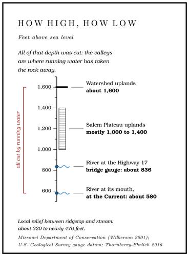
The watershed’s uplands reach about 1,600 feet above sea level. The river’s Gauge. A station of the Geological Survey that records the river’s stage, from which its flow is figured. The Jacks Fork has gauges at Highway 17, Alley and Eminence (Chapter 14). Glossary → at the Highway 17 bridge stands at about 836 feetUSGS NWIS, site 07065200 (gage datum 836.06 feet)., and the water reaches the Current River at about 580Wilkerson 2001, PDF 10.. At sites sampled for fish along the river, the local relief between ridgetop and stream runs from about 320 to nearly 470 feetWilkerson 2001, PDF 10.. All of that depth was cut. The rock under the plateau and the rock in the Bluff. A cliff along the river, usually on the outside of a bend, where the river has cut sideways into the hill. In this sense the word was first used in North America (Chapter 2; Chapter 18). Glossary → are the same flat-lying layers (Chapter 1), and the valleys are where running water has taken the rock away.
A plateau cut into hills
Geologists describe the Ozarks as a dome, a broad and lopsided one whose high point is the old igneous core of the St. Francois Mountains (Chapter 1). From that core the rock layers slope gently outward in every direction, so gently that to the eye they look levelSauer 1920, 7 (“a broad, asymmetrical dome, whose apex is formed by the igneous rocks outcropping in St. Francois and adjacent counties”; “the rocks appear to the eye to be horizontal”).. Erosion has planed off the top of the dome, so its rocks come to the surface in rings, like the cut end of an oniongeneral description of an eroded dome., with the oldest at the center and younger layers outward. The whole uplifted region, the Ozark Plateaus, covers about 50,000 square milesThornberry-Ehrlich 2016, 1. of Missouri, Arkansas, Kansas and Oklahoma. The Jacks Fork and the Current drain the part called the Salem Plateau, a country of rolling uplands mostly between 1,000 and 1,400 feetThornberry-Ehrlich 2016, 3; Wilkerson 2001, PDF 10. above sea level, with deeply cut stream valleys below them.
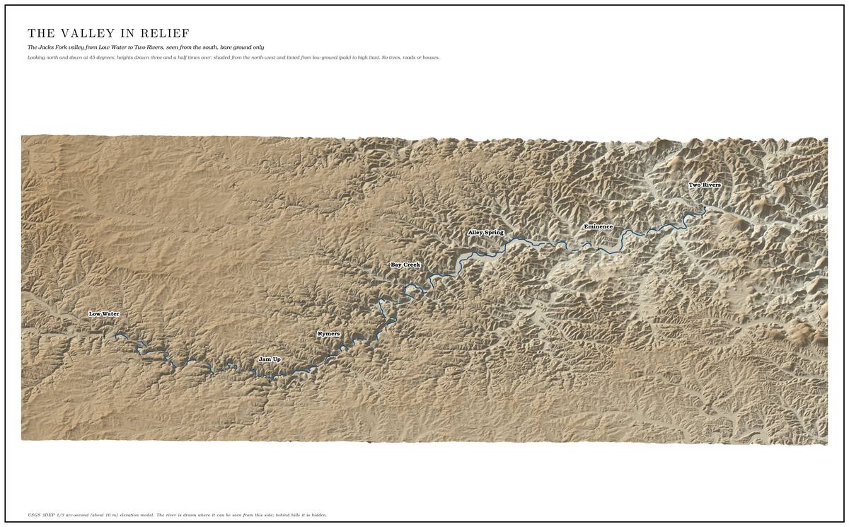
The same plateau has been worn very differently from place to place. Its western part, far from any large river, is still a plateau. Its eastern part is mostly rough hill countrySauer 1920, 6 (“is still a plateau”; “is principally rough hill country, formed by the intricate dissection of the plateau surface”)., where streams have cut the old surface into intricate valleys. A creek that drains to a big river close at handgeneral explanation. has a low outlet nearby and a steep run to it, and it cuts down hard, while one far from any large river has a long, gentle way to go and little power to cut. A geographer who divided the Missouri Ozarks into regions in 1920 drew his lines on that basis, and the Jacks Fork runs from one of his regions into another. The upland of Texas and Howell counties, where the river begins, belongs to his Central Plateau, one of only two parts of the Ozark plateau that streams had not cut up extensively, with farms mostly on the upland and the cherty Howell soilSauer 1920, 70 (“which has not been dissected extensively”). the commonest. That soil, weathered mostly from the Jefferson City Dolomite, was the most widespread single soil of the Ozarks. In Howell County its Chert. A hard, fine-grained form of silica that forms in nodules and beds inside dolomite and stays behind when the dolomite dissolves. Most Ozark people call it flint. It makes up the river’s gravel and was the stone of the first people’s tools (Chapter 1; Chapter 3). Glossary → breaks down into small pieces, so the ground is gravelly rather than stony, and by 1920 it had been advertised hard as fruit land, with large commercial orchards set out on it in Howell and Oregon counties, though probably most of it had never been plowedSauer 1920, 38 (“the most extensive single soil type of the Ozarks”; “advertised heavily as fruit soil”; “Probably the major part of it has never been put under cultivation”).. ShannonSauer 1920, 62 (fig. 18). County lies in what he named the Courtois HillsSauer 1920, 68 (“steep-sided, chert-covered ridges, monotonous in their similarity”)., for Courtois Creek in Crawford County, one of the first valleys settled there. The Courtois Hills are steep-sided, chert-covered ridges, much alike, most of them forested in oak, where the people live in the valleys and, in his words, “the distance by road at least doubles the airline distance between two points.” They cover roughly the main outcrop of the Gasconade and PotosiSauer 1920, 68. formations, and that rock gives them the steepest average slopes of any part of the Ozarks, a maze of deep, narrow valleys and nearly knife-edged ridgesSauer 1920, 14 (“the steepest average slopes of any part of the Ozarks”; “maze of deep, narrow valleys and almost knifelike ridges”).. They are the most rugged country in the OzarksThornberry-Ehrlich 2016, 1..
Nearly all of the Eminence and Cardareva quadrangles lie in the Courtois Hills, with only a small area in the west and southwest on the margin of the Central Plateau. The hilltops rise to nearly the same height, and from any high point the skyline looks level. The average hills there rise 400 to 550 feetBridge 1930, 29. above the valleys. The even hilltops were long taken for the last pieces of an old upland surface (see “The Peneplain. A broad plain worn nearly flat by rivers. An older reading took the even hilltops of the Ozarks for the remnant of one (Chapter 2). Glossary →” below), and patches of it survive along the divide between the Jacks Fork and the Eleven Point, the eastern edge of the undissected Central Plateau. The largest on the map of the 1920s is the Flat Woods, northwest of Eminence. At first sight it seems a broad stretch of gently rolling, forested upland, but the road follows a long, flat-topped, narrow, winding ridge with ravines dropping 200 to 500 feet on either side. Ridges of that kind can be followed for miles without climbing or descending more than 60 to 80 feetBridge 1930, 30–31 (the skyline “is decidedly level”; “the first impression obtained is that the country contains broad areas of gently rolling, forested upland”)., until they end at a river bluff or taper down into a valley.
A Scottish botanistJohn Bradbury, quoted in Sauer 1920, 6, citing Bradbury in Early Western Travels, vol. 5, 244–45; Sauer credits Bradbury with first grasping the character of the Ozarks. traveling the West in the early 1800s was among the first to see what had shaped the Ozarks. Comparing them with the plains, he wrote: “Although the surface is more broken and uneven, it is entirely owing to the more powerful action of the streams.”
The Jacks Fork watershed covers about 445 square miles of Texas, Howell and Shannon counties. The North Prong begins about nine miles south of RaymondvilleWilkerson 2001, PDF 1, 5. and the South Prong about ten miles east of CaboolUSGS GNIS (source of South Prong Jacks Fork; Cabool), distance measured; Wilkerson 2001, PDF 5, gives “approximately 5 miles east of Cabool,” which fits the head of the large unnamed creek that joins the prong from the west; see Reach B.. Both rise on the high, gentle ground of the plateau, and on the northwest their heads reach the main divide of the Missouri Ozarks, the line that separates the streams that flow north to the Missouri River from those that flow south to the White. Rain falling a few yards apart on that line can reach the Mississippi by the Missouri, just above St. Louis, or by the Whitegeneral geography., in southeastern Arkansas, hundreds of miles farther down. In the Clear Springs quadrangle of Texas County the flat upland along the summit of that divide disappears for about fifteen miles, eaten away by ravines working backBretz 1965, 35 (ravines “gnawing back from Jacks Fork of Current River on the east”). into it from the Jacks Fork on the east and from the Gasconade River on the west. The hollows at the head of the Jacks Fork are cutting back into the crest of the Ozarks.
When the dome rose
The Ozark region has stood high for a very long time. The rise of the dome is tied to the late Paleozoic Era, roughly 300 million years ago. As the Ouachita MountainsThornberry-Ehrlich 2016, 58–59. rose to the south, their weight bent the crust down beneath them and pushed up a broad bulge in front of them, the way a mattress rises beside a heavy weight pressed into it, and the Ozark dome rose in that bulge, which geologists call a forebulge. Since then the Ozarks have been an example of long-term stabilityBeeson, McCoy and Keen-Zebert 2017. in the interior of a continent.
How high it has stood since, and why, is less settled. The loose Mississippian chert on the uplandsWeary and others 2014, 7. (Chapter 1) shows that the region was probably under a shallow sea as late as the Mississippian Period, so it has risen since. The plateau has probably risen at least a few hundred meters since the end of the Paleozoic, and whether the present heights are left over from that early uplift or come from later movementBrown and Marshak 2004 (“it is not clear whether the present-day elevations are a residual of earlier uplift”). is still open. One clue comes from crystals of the mineral apatite in the old Granite. A coarse-grained rock made of magma that cooled slowly underground. Granite near Big Spring has been dated at about 1.46 billion years (Chapter 1). Glossary →. A uranium atom in such a crystal now and then splits in two, and each split leaves a tiny scar, a track, through the crystal. While the rock is hot the tracks heal as fast as they form, but once it cools below about 100 degrees Celsiusgeneral explanation of fission-track dating. they last, and counting them gives the time since the rock came up through that temperature on its way toward the surface. The tracks in the Precambrian granites of the region suggest that erosion has stripped it at an average of roughly ten meters every million years over the last 200 million yearsBeeson, McCoy and Keen-Zebert 2017, citing apatite fission-track ages., some 6,500 feetcomputed. of rock in all.
The peneplain
For most of the twentieth century the standard account of the Ozark landscape was built on an idea called the peneplain, a nearly flat plain worn down by long erosion close to sea level. In that account the highland was an old plain lifted up on domed rocksSauer 1920, 6 (“an elevated peneplain, developed upon domed rocks”).. The region was worn down after the Paleozoic until slow rivers wandered in wide loops across a low, level surface. Then the land was raised again. The rivers, already set in their winding courses, kept them and cut straight down, so that loops formed on a flat plain became loops carved hundreds of feet deep into rock. Geologists call such loops Entrenched meander. A meander is a loop of a river, and an entrenched meander is one cut hundreds of feet down into rock, as the loops of the Jacks Fork are (Chapter 2). Glossary →, and the account took the meanders of Ozark rivers for an inheritance from the time when sluggish streams wandered widely over a smooth surfaceSauer 1920, 24 (the meanders “are inherited from a peneplained condition of the region, when sluggish streams wandered widely over the smooth surface”).. The flat uplands like the one around Mountain View were taken to be surviving pieces of the old plain.
Around Eminence the idea was worked out on the ground during the mapping of the 1920s (Chapter 1), which found three levels in the landscape. The highest was the summit level, the hilltops of even height. It was read as the remnant of a broad plain worn low by rivers that had reached Grade. The slope at which a river carries its load without cutting down or building up (Chapter 2). Glossary →, the slope at which a river carries its loadgeneral definition of grade. without cutting down or building up, and on that reading the plain was finished about Pliocene time, some five million to two and a half million years agogeneral.. Then the whole Ozark region was bowed up, by 300 to nearly 400 feet around Eminence, about the height of the tallest bluffssee Map 13 below. on the Jacks Fork. The rivers, set in their meanders, cut down into the rock and kept them, because a river trenched into rock can no longer swing to a new coursegeneral. the way it could across a soft plain. A pause followed, long enough for the main streams to reach grade again and widen their valleys, and that pause left the second, intermediate level, a high, much-dissected Terrace. A level bench above a river, the remains of an older floodplain left high when the river cut down (Chapter 2). Glossary → along the main streams. It shows best near Eminence in the level tops of the low hills on the north side of the Jacks Fork, about a mile northeast of town, at about 800 feet above sea level. On the main streams it averages about twice the width of the present valleys, and it survives in patches, first on one side of a river and then on the other, the raised and cut-up remains of a wide valley floor left when the uplift halted for a time. Thin deposits of river-worn gravel lie on it in a few places, with boulders carrying Mississippian fossils among the chert. On the smaller streams the same level survives only where a creek crosses one of the Porphyry. The old Missouri name for rhyolite, from the scattered crystals in its fine-grained body (Chapter 1). Glossary → ridges, at the narrow, rocky gorges that Ozark people call Shut-in. A narrow, rocky gorge where a stream cuts through hard rock (Chapter 2). Glossary →Sauer 1920, 11; see Chapter 1. (Chapter 1). Upstream of such a crossing the creek runs across a small flat held up by the hard rock below it, and in the 1920s these were called shut-in plains. At first sight each looks like a level set by the hard rock alone, but most of them stand at the height of the cut-up terrace along the main streams, and they have lasted because the rock beneath is hard and the creeks that drain them are small. The valley of Rocky Creek above the falls and two flats on smaller creeks nearby are the clearest of them, and they were then the only parts of the intermediate level big enough to farm, most of them under the plowBridge 1930, 32 (the “‘shut-in’ plains,” whose elevation “agrees with that of the much dissected terrace along the main streams”; Prairie Hollow and the upper valley of Little Rocky Creek, east of Eminence, the other two; “the only portions of this intermediate level which are large enough to be farmed, and most of these areas are under cultivation”).. Then the land rose again, and the rivers cut about 200 feetBridge 1930, 31–32, 53–54 (the intermediate level as “a high, much dissected terrace,” “first on one side and then on the other,” “the uplifted and dissected remnant of a wide valley,” marking “a temporary halt in the uplift of the region”). below that second level to the third, the present Floodplain. The flat valley floor that a river builds and floods (Chapter 2). Glossary →.
The youth of that last cutting shows in the bluffs. The cliffs along the main streams rise from the floodplains, some of them more than 200 feet, but none of them reaches above the intermediate level, and the slopes between that level and the summits are often steep but never sheerBridge 1930, 33, 54 (“often steep” but “never precipitous”).. The rivers had not yet had time to wear their newest walls back. The geology of the day spoke of rivers passing through youth, maturity and old agethe cycle of erosion then current, general., and in the 1920s the main streams were classed as in late youthBridge 1930, 39 (“in late youth”)., in a pause again, approaching grade and beginning to widen their valleysBridge 1930, 54..
The peneplain kept its defenders into the 1960s. One reading of that time found three successive peneplainsBretz 1965, 21. in the Missouri and Arkansas Ozarks and took the deeply entrenched meanders of Ozark rivers as the record of rivers that had once flowed at a lower, earlier Base level. The lowest level a river can work down toward, set in the end by the sea. A drop in base level sets the rivers upstream cutting into their beds (Chapter 2). Glossary →Bretz 1965, 37 (“strikingly entrenched meanders of Ozark rivers”).. It rejected the rival ideas of the day, among them the view that hills and valleys come into balancethe view of John Hack, rejected in Bretz 1965, 19–20, 33. with the processes wearing them down and keep their shape as they are lowered, with no peneplain required.
Newer work has added a complication. It measures how fast the land is wearing down with beryllium-10, a rare form of the element made when cosmic rays from space strike grains of quartz at the ground surface. The longer a grain lies near the surface before it is washed away, the more beryllium-10 it gathers, so sand from slowly wearing ground carries more of it than sand from ground being stripped fast, and sand from a river’s bedgeneral explanation of cosmogenic-nuclide erosion rates., gathered from the whole basin, gives an average for the basin. Across the Ozark basins sampled, the land is being lowered at about 4 to 15 meters per million years, an average of about 8, roughly a third of an inch every thousand years. At that pace, lowering the country by the height of the tallest bluff on the Jacks Fork, about 350 feet, would take some thirteen million years350 feet at 8 meters per million years, computed.. Neighboring basins can differ by a factor of two. On that evidence the Ozark dome is out of balance. River basins compete with their neighbors, the divides between them migrate, and one river can capture the headwaters of another, on scales from a square kilometer to a thousand. That competition probably continues to shape the large-scale form of the dome, and the river network will likely never settle into a steady stateBeeson, McCoy and Keen-Zebert 2017 (the dome “not in a state of equilibrium”; the network “will likely never achieve steady state conditions”).. The ravines working back from the Jacks Fork into the main divide are probably part of that competition.
Every account of the Ozarks shares the mechanism that does the cutting. A river cuts down when it has somewhere lower to go. The Jacks Fork drains to the Current, the Current to the Black near Pocahontas, Arkansas, the Black to the White and the White to the Mississippi, which empties into the Gulf of Mexico. The lowest level a river can work down toward is its base level. Higher sea levels raise base level, and the rivers upstream cut less. When sea level falls or the land upstream rises, the drop in base level sets the rivers cutting down into their beds. The cutting starts low and travels upgeneral explanation.. The lower river, suddenly higher than it needs to be, deepens its bed first, and the steepened stretch above the deepened part works its way upstream as a run of rapids, into every tributary in turn. Early in the Cenozoic Era, the last 66 million years, the Gulf of Mexico repeatedly flooded the lower Mississippi Embayment and filled it with thick marine sediment, and those changes reached the whole Mississippi system, the Current and the Jacks Fork included. The ice ages, which locked up enough water in ice sheets to lower the sea, did the most to shape the modern lower Mississippi valley. Gravel left perchedThornberry-Ehrlich 2016, 59–60. above the present floodplains records the levels the rivers ran at when base level stood higher (see “Floodplains and terraces” below). No one has put a date on when the Jacks Fork began to cut its present valley.
Cutting down
On an ordinary summer day the Jacks Fork does almost nothing to its bed. Its water is clear because it carries little, and its gravel lies still. The work happens in floods.
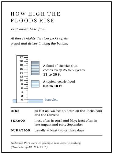
Water on the Jacks Fork and the Current can rise as fast as two feet an hour. A typical yearly flood lifts the river six and a half to ten feet above its Base flow. The flow that keeps a river running between rains. On the Jacks Fork most of it comes from springs (Chapter 12). Glossary →, and a flood of the size that comes every 25 to 50 years lifts it 13 to 20 feetThornberry-Ehrlich 2016, 11.. Floods come most often in April and May and least often in late August and early September, and they usually last at least two or three daysThornberry-Ehrlich 2016, 36. (Chapter 14). At those heights the river picks up its gravel and drives it along the Bottom. The flat land along a river or creek, built of its deposits and open to its floods. In the 1920s the bottoms near Eminence averaged about a quarter of a mile wide (Chapter 2; Chapter 5). Glossary →. The size of stone a current can move rises very steeply with its speed. By a rule long used in river work, doubling the speed of the water lets it shift stones some sixty times heavier, so a flood running a few times faster than the summer river can roll cobbles that lie still for years. The gravel, rolling and bouncing, chips and scours the rock like a slow belt sander. Fast water also plucksgeneral; the “sixth-power law” of stream competence. at the bed, working into the cracks and the partings between layers and lifting out loosened blocks whole. The same weak acid that dissolves caves (Chapter 13) works on the bed and banks, especially along cracks and between layers.
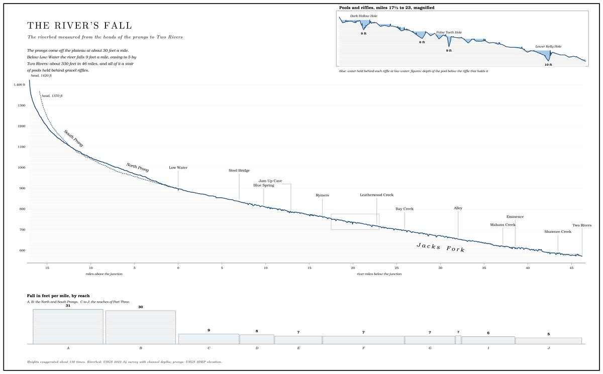
The Jacks Fork is steep, and steepness gives a river power. The North Prong heads at about 1,420 feet above sea level and the South Prong at about 1,370, and both come down at about 30 feet a mile; the smallest headwater Branch. A small creek. The sense is American, on record from 1674 (Chapter 18). Glossary → of the watershed fall about 130. Below the junction the fall eases. Measured along its bed, the river drops about 9 feet a mile from Low Water to Steel Bridge, 8 from there to Muck Forty Hole, 7 on past Rymers and Bay Creek to just below Alley Spring, 6 from there to Eminence and 5 from Eminence to the Current, about 330 feet in its 46 miles (Map 12). An older reckoning of the mainstem from the topographic maps, 7.1 feet a mileWilkerson 2001, PDF 12, 32 (table Ge05), over a mainstem it measures at 49.1 miles., comes to about the same average. Most of the drop is spent at the Riffle. A fast, shallow, rocky stretch between pools. The riffles are the gardens of the riverbed: in July a square meter of riffle produced more than six times as much as a square meter of pool (Chapter 16). Glossary →, where the water spills over sills of gravel, and the Pool. A deep, slow stretch of river between riffles (Chapter 16). Glossary → between them lie nearly level, so the bed of the river is a long stair of pools held back by gravel riffles, the deepest pools 8 to 10 feetthe river profile measured on the 2021–23 riverbed survey (Heimann, Atkinson and High 2025; Map 12). The figures by stretch are the means for Reaches C to J (Part Five); depth is a pool’s depth below the riffle that holds it. below the riffles that hold them (Chapter 19). The steady easing of the fall downstream, from 30 feet a mile in the Prong. A branch or arm of a creek, set down in 1860 as Southern usage. The North and South Prongs join to form the Jacks Fork (Chapter 18). Glossary → to 5 near the mouth, is the usual shape of a river’s profile, steep at the head and flattening toward the mouth. Downstream the river carries more water, and a bigger river needs less slopegeneral explanation of the concave long profile. to move the same gravel, so the bed can lie flatter and still pass along what comes down to it. The basin slope that hydrologists use in estimating floods is 9.5 feet a mile for the Jacks Fork at Eminence and 5.92 for the Current at Van Buren; Missouri basins the size of the Jacks Fork’s average 5.8Wilson 2001, 2 (basin slopes, after Alexander and Wilson 1995; 5.80 is the state average for basins within 10 percent of the Jacks Fork’s drainage area, and 3.45 the average for basins the size of the Current’s). The National Park Service’s geologic inventory (Thornberry-Ehrlich 2016, 11) gives 9.5 as the river’s fall through the park and 3.45 as the state average. (Chapter 14).
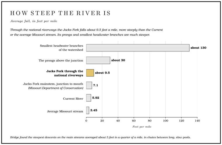
The river does not fall evenly, and in the 1920s its many low rapids were taken as a sign that it had not yet reached grade. Some rapids form where a hard layer crosses the river, others where a tributary has dumped a large Gravel bar. A bank of chert gravel and sand, usually on the inside of a bend, bare at low water (Chapter 15; Chapter 18). Glossary → into it. The main streams have no waterfalls. The steepest descents on the main streams of the Eminence country then averaged about 5 feet in a quarter of a mile, in Chute. A narrow, fast slot of water through a shoal or past an obstacle. A smooth V of water pointing downstream marks the deepest path through it (Chapter 20). Glossary → that alternate with long, slow pools. Above some of the riffles the river has built a temporary grade, and on those level stretches the Jacks Fork had begun to wind in a few small floodplain meandersBridge 1930, 39 (the main streams “not yet at grade, as is shown by the numerous low rapids along their courses”; “a few incipient flood plain meanders”).. Hard layers rarely narrow the valleys of the larger streams. The clearest case is on the Jacks Fork, a narrow gorge a mile or two above Eminence where a hard bed of sandstoneBridge 1930, 36 (sec. 28, T. 29 N., R. 4 W.). crosses the river.
Cutting down this way is slow, and nobody has measured a rate for the Jacks Fork’s channel. The Current, the Jacks Fork and their tributaries are still cutting down into their bedsThornberry-Ehrlich 2016, 60 (“continue to incise their channels”)..
The evidence of that cutting is stored high in the walls. As a river cuts down, the Water table. The level below which every crack and pore in the ground is full of water (Chapter 12; Chapter 13). Glossary → in the hills around it falls too, and passages that once carried water at the level of the river are left high and dry. The Gasconade Dolomite in particular is honeycombed with such abandoned passages, while lower in the same rock the springs of the present day come out of channels that are still being dissolvedSauer 1920, 19 (“With increasing dissection of the surface, the underground drainage suffers readjustment and former channels are abandoned, appearing here and there on hillsides as dry caves”; the Gasconade “especially is honeycombed by such abandoned passages”; springs “issuing from solution channels of the present cycle”).. Many caves in the Current River country are stranded well above the present groundwater surface, some with rooms and channels as large as the flooded conduits that feed Alley SpringWeary and others 2014, 8. today. A dry cave in a bluff marks where the water tableThornberry-Ehrlich 2016, 15. once stood, and a spring at the foot of the same bluff marks where it stands now (Chapter 13). The cutting also works the other way. On the Jacks Fork at least one cave was probably a pocket packed with clay until the river cut down far enough to open it, and floodwater then carried in river siltMSS 1982, 56 (“probably a filled pocket until the down-cutting river exposed it and replaced the clay sediments with silt”). in place of the clay.
The high caves can also be made to tell time. Quartz grains lying near the ground surface collect rare forms of aluminum and beryllium made by cosmic rays. Once floodwater washes a grain deep into a cave, the supply stops, and the two kinds of atoms decay at different rates, so the ratio between them gives the time since burialgeneral explanation of cosmogenic-nuclide burial dating.. No cave on the Jacks Fork has been dated this way. In Fitton Cave, beside the Buffalo River in the Arkansas Ozarks, gravel and sand in the upper passages have been dated by that method, by the magnetism frozen into their clay and by the uranium in the Flowstone. Calcite laid down in layers by water flowing across a cave floor or wall (Chapter 13). Glossary → that later sealed them over. Gravel poured into the passages about 2.2 million and 1.25 million years ago, in pulses that line up with cold glacial times (see “The cold centuries” below), and the river had begun to leave those passages before about 720,000 years ago. Over the last 850,000 years the valley there has deepened by about 27 metersHudson and others 2025 (burial, luminescence, paleomagnetic and uranium-series ages; the gravel pulses matched to glacial tills about 300 kilometers north)., some 90 feet, every million yearsconverted..
Where the river starts
The prongs are plateau streams. In the state’s ecological classification, which happens to reuse the name Central Plateau, the upland of the upper watershed belongs to the Central Plateau subsection, where the headwaters are typically intermittent, gentle in grade and often losingWilkerson 2001, PDF 37–38. water to the rock beneath them. The North Prong runs about seventeen miles to the junction and the South Prong about sixteenWilkerson 2001, PDF 31 (table Ge04)..
Hydrologists rank streams by ordergeneral explanation of Strahler stream order.. The smallest branches, with no tributaries of their own, are first-order. Where two first-order streams meet, the stream below is second-order, and where two second-order streams meet, it becomes third-order, so a stream’s order climbs only when it is joined by one of equal rank. Where the prongs meet, the Jacks Fork becomes a sixth-orderWilkerson 2001, PDF 12. stream, the largest in the watershed, and within a little more than a mileWeary and others 2013, GIS data, laid against the river centerline. it has cut down into the Gasconade Dolomite (Chapter 1). Below that it runs in the Current River HillsWilkerson 2001, PDF 37., the subsection of rugged, cut-up country where the valleys go down through the Roubidoux into the Gasconade and Eminence dolomites.
The change from plain to breaks comes abruptly, and the rock explains why. Thick beds of sandstone underlie most of the upland, and a valley cut in them widens about as fast as it deepens, which gives the plateau its gently rolling surface. Once a stream cuts through the sandstone, it reaches Dolomite. Calcium magnesium carbonate rock, a close relative of limestone, formed from lime mud on the floor of a warm, shallow sea. Nearly every bluff on the Jacks Fork is dolomite (Chapter 1). Glossary → that dissolves and wears away far more easily, and it trenches the dolomite fast. The sandstone above acts as a protective cap and holds back the widening of the valley, and the result is deep, narrow valleys with over-steepened sidesBridge 1930, 31 (“with great rapidity”; “deep narrow valleys with over-steepened sides”).. On the upper Jacks Fork the broad, flat divide gives way in just this manner to the extremely abrupt valleyWilkerson 2001, PDF 63 (table Lu04). of the breaks.
Hollows
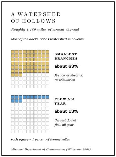
Most of the Jacks Fork’s watershed is hollows. Of the roughly 1,189 miles of stream channel mapped in it, about 63 percent are first-order streams, the smallest branches. That is about two and two-thirds miles of channel for every square mile of the watershed. Only about 13 percentWilkerson 2001, PDF 12. of the watershed’s stream miles flow all year, some 150 milescomputed from the same figures and the watershed’s 445 square miles. in all, and the rest run only after rain. The hollows that hold them are the steepest part of the drainage.
Many of them barely look like stream valleys. In the Gasconade country many tributaries occupy blunt-headed valleys 100 to 200 feet deep that show only faint traces of a stream channel. One old explanation, put forward in 1892, is that dissolving went on underground until the roof caved inSauer 1920, 14 (“many of the tributary streams occupy blunt-headed valleys with a depth of one to two hundred feet,” which “ordinarily show only obscure traces of a stream channel”; the origin by “subterranean solution, continued until the roof has caved in,” suggested by Frank L. Nason in 1892).. The Gasconade suits that process, because dissolving goes on so actively in it that it has many large caves and springs and very little water running on the surface. Water that falls in such a hollow mostly sinks into the chert and rock and travels underground. Many of the creeks of the Jacks Fork country are Losing stream. A creek that gives up its flow to the bedrock and runs dry for long stretches. Jam Up Creek, Pine Hollow and Johnny Hollow are the officially listed losing streams of the watershed (Chapter 12). Glossary →Wilkerson 2001, PDF 11 and table Lu04., which give up their flow to the bedrock and run dry for long stretches (Chapter 12).
Most of the small tributaries are dry valleys floored with a thick mantle of chert fragments and soil. The mantle soaks up the rain, so a stream runs on the surface only after heavy and prolonged rains, and many of these valleys have no definite channel at all. Where a tributary does run all year, it usually starts at a fairly large spring and begins as a creek of some size. In the Eminence country no permanent spring of any size rises above about 900 feet, and most of the permanent streams begin between 900 and 760 feetBridge 1930, 35–36, 45., which probably marks the level of the permanent water table there.
The hollows also lengthen by swallowing sinks. A sink in the upland just beyond the head of a tributary valley is a common sight, and valleys often grow headward by capturing them, either when groundwater undermines the rim until it collapses or when water filling the sink to overflowing cuts the rim down. Many of the abrupt, bowl-shaped heads of the tributary valleys are probably breached sinksBridge 1930, 42–43 (“no uncommon thing”; valleys “often lengthen headward by the capture of sinks”; “Many of the abrupt, cirque-like heads of the tributary valleys may very well be breached sinks”)..
Bluffs on the outside of the bends
Float any stretch of the Jacks Fork and a pattern shows itself. The tall bluffs stand on the outsides of the bends. The long, low gravel bars, and the gentle wooded slopes behind them, lie on the insides.
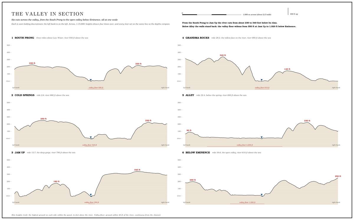
The pattern starts with the water. When a river goes around a bend, its momentum carries it toward the outside, the way passengers in a car lean outward on a curve. The fastest, deepest current hugs the outer bank and scours a Hole. Any pool deep enough to swim or fish in, named or not, the basic unit of the river in local speech; also “hole of water” (Chapter 18). Glossary → at its foot. The water piled against the outer bank sinks there and returns across the bottom toward the inside of the bendgeneral explanation of the secondary current in a bend., so the whole current turns over slowly as it goes around, and along the bottom it sweeps gravel toward the inner bank. On the inside of the bend the water slows, and slow water drops what it carries. Gravel piles up there as a point bar.
Then add time. Year after year the outer bank is undercut and pushed back, and the inner bank builds out. The bend creeps sideways and downstream. Meanwhile the river is also cutting down. Combined, the two motions give the cross-section of an Ozark valley. On the outside of each bend the river has sawn down and sideways into the hill, leaving a cliff. On the inside it has slid away, step by step, from its own earlier positions, leaving a long, gentle slope that geologists call a Slip-off slope. The long, gentle slope on the inside of a river loop, left as the river slid away from its earlier positions (Chapter 2). Glossary →.
At the outside of a typical Ozark meander the river cuts sharply into the upland and in most cases leaves a sheer bluff, while down-cutting and sideways shifting together give the gentle slopes on the inner sides of the loopsSauer 1920, 24, 25 (fig. 6).. A geographer writing in 1920 found those slip-off slopes “invariably the sites of the choicest farmsSauer 1920, 24., the lower slopes being farmed, the upper ones utilized as grasslands.” A meander in hard rock is also less likely to cut through its own neck. In the rugged interior of the Ozarks, where the streams run fast and the rock resists, the loops grow and wander without being cut off, and the cutoffs and old oxbows are found mostly along the slower rivers of the border regionsSauer 1920, 25..
Measured along its channel, the Jacks Fork runs about 46 miles from the junction of the prongs to the Current. A straight line between the two points is about 26 miles, so the river travels about a mile and three-quarters for every mile it advances. That ratio, the channel length divided by the straight-line distance, is the river’s sinuosity, and a ratio of 1.5Erwin, Jacobson and Jones 2021, 9. is the usual threshold between a meandering river and a relatively straight one. Measured over five-mile stretches, the Jacks Fork’s ratio runs from about 1.4 to 1.9, and the figure changes with the length of the stretchErwin, Jacobson and Jones 2021. measured. The tightest loop on the river is near its head. Below Low Water, around Harlow Fordmeasured along the river centerline; USGS GNIS (Harlow Ford)., the channel swings through a loop of about 1.4 miles and comes back to within about 1,150 feet of itself.
Jam Up Bluff and Angel Ridge Bluff, both in the Jacks Fork Natural Area, are among the state’s representative Limestone. Calcium carbonate rock formed from lime mud and shells on a sea floor. Most of the limestone laid down here later became dolomite (Chapter 1). Glossary → and dolomite cliffsMDC, “Cliffs.”. Deep holes form at the feet of bluffs like these, where the river strikes the outside of a bend (Chapter 15; Chapter 19). The bars build on the insides of the bends and also where tributaries come inThornberry-Ehrlich 2016, 11 (fig. 7), 12., as a steep creek drops its load into the slower main river.
In many places the floodplains are bordered by bold cliffs as much as 200 feetBridge 1930, 33. White Bluff is in sec. 9, T. 28 N., R. 5 W., placed here by that land-survey description. high, many of them along the Current and the Jacks Fork. White Bluff on the Jacks Fork, in the stretch around Bay Creek, is over 200 feet high, and a geologist who saw it in the 1920s wrote that it rises “so precipitously out of the river that a person standing on the edge . . . can easily throw a stone across the river.” The Gasconade stands in bold, steep bluffs, often more than 100 feet high, on the upper Jacks Fork, particularly above the mouth of Alley BranchBridge 1930, 113.. Farther down the river reaches the older Eminence Dolomite (Chapter 1), which forms cliffs along the stretch of the Jacks Fork between Lick Log Hollow and the junctionBridge 1930, 85. with the Current.
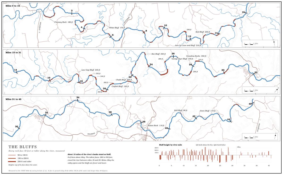
Measured on the terrain model of the riverbed and valley made for the flood maps (Chapter 15), about ten miles of the river’s banks, the two sides counted together, are bluff 50 feet tall or more, and about eight of those miles lie above Alley (Map 13). Nearly all the tallest faces, 280 to 350 feet, stand between miles 18 and 29, from Lodder Bluff below Bunker Hill to the bend at Grandma Rockssee Reaches F and G.. The tallest of all is the face on the left bank across the river from Grandma Rocks, at about mile 28.3, which rises about 350 feet above the water. Below Alley the valley opens, the bluffs are fewer and lower, and none rises much above 160 feetmeasured on the flood-mapping terrain (Heimann, Atkinson and High 2025; Map 13). Every bluff height in this book is the top of the continuous steep face above the water, rounded to 10 feet. A face is counted where the ground rises at least 50 feet within about 150 feet of the water at a slope steeper than 30 degrees; the 117 faces so found, their lengths summed along the river for both banks, come to about 9.7 miles, 8.5 of them above the Highway 106 bridge at Alley. Ten of the eleven faces over 280 feet lie between miles 18.7 and 28.4; the eleventh, about 290 feet, is on the left at about mile 11.4. The tallest, 347 feet, is the left-bank face at about miles 28.27 to 28.33, across from Grandma Rocks; the tallest below Alley, about 160 feet (164.6), is on the left near mile 45.0 (see Reach J)..
The valley itself changes along the way. For roughly its first twenty-two miles inside the park the valley is narrow, and the channel is narrow with it, held in by the Roubidoux Formation. Farther down, through the Gasconade, Eminence and Potosi dolomites, the valley widens, the channel varies more in width and runs against the valley walls less often, and the gravel bars grow larger. There is more gravel below Leatherwood CreekErwin, Jacobson and Jones 2021, 12, 34 (about the upper 35 kilometers of the channel studied; “In general, there is more gravel downstream from Leatherwood Creek, where valley width increases and the channel is less confined”)., where the valley widens and the channel is less confined.
The abandoned meander at Eminence
A meander cut into hard rock rarely cuts through its own neckSauer 1920, 25., but near Eminence the Jacks Fork has abandoned one of its loops by cutting through the neck, the narrow strip of groundgeneral. between the two arms of a loop. About a mile northwest of town the river once flowed up the lower part of the valley of Storys Creek and around a small Knob. The old Missouri name for a hill of hard volcanic rock, such as those near Eminence and the mouth (Chapter 1). Glossary →, and then cut across the neck of the loop. The floor of the old channel lies only 20 or 30 feet above the present one, so the river ran that way until fairly recent times, as geologists reckon them.
The cutoff could have happened in two ways. The river could have undercut the neck from both sides until it broke through in a flood. More probably, groundwater dissolved a passage through the dolomite of the neck along its Joint. A crack along which rock has split without moving. In the riverways the main sets run north-south and east-northeast (Chapter 1). Glossary → and bedding planes, so that some of the river crossed underground by the shorter, steeper route. A passage like that enlarges quickly, takes more and more of the water until the whole stream runs through it, and finally loses its roof. The earlier Stage. The height of the water surface above a gauge’s datum, the reading a gauge records. A stage differs from the depth of the water. At Eminence the datum stands 616.18 feet above sea level (Chapter 14). Glossary → of that sequence can be seen on Sinkin Creek, a tributary of the Current in northern Shannon County. On its Barren Fork the creek sinks on one side of a meander and comes out in a large spring about half a mile away on the other. On Sinkin Creek itself, a meander about three-quarters of a mile long has been abandoned for a tunnel under its neck, large enough to take a boatBridge 1930, 34–35 (fig. 2, plate 6), and figs. 3–4 (“Originally Jacks Fork flowed up the lower portion of the valley of Storey’s Creek, and around the small knob”; the river “occupied this course until comparatively recent times”; the groundwater route judged the more probable). through. The cutoff on the Jacks Fork is the last stage, with the tunnel collapsed and the cut completed. On the upper river, by one reading, Jam Up Cave is an underground shortcutBridge 1930, 22, the only source (“a subterranean short-cut by which Jam-Up creek enters Jacks Fork several miles above its former mouth”). of the same kind, by which Jam Up Creek now reaches the Jacks Fork several miles above its former mouth (Chapter 12; Chapter 13).
How bluffs wear back
A big Jacks Fork bluff is rarely a smooth wall. It is a stack of ledges, overhangs and recesses, because its layers wear at different rates. Beds of sandstone and chert resist. The dolomite between them dissolves and crumbles faster. Water seeping along a sandstone layer dissolves the dolomite above and below it until the harder bed overhangs. Frost wedges blocks loose in winter, and tree roots pry at the cracks all year. Where the Gunter Sandstone, at the base of the Gasconade, crops out in the bluffs, it tends to form a bench, and small streams pour off it in little waterfallsThornberry-Ehrlich 2016, 25..
The rock layers wear in their own styles. Sheer cliffs of Gasconade show very little bedding or jointing, but where the river is cutting down less actively, the same well-bedded rock weathers into a series of step-like ledges one to four feet high, often separated by open grassy slopes. Where the river is cutting at the foot of a cliff, it carries off whatever falls and keeps the face fresh, and where it has swung away, the fallen rock stays and the face probably weathers back into stepsgeneral explanation, offered as probable.. That stepped weathering is typical of the Gasconade and the Roubidoux, and it differs sharply from the craggy, pinnacledBridge 1930, 103, 111, 113. surfaces of the older Eminence Dolomite beneath them.
Sooner or later a slab lets go. RockfallThornberry-Ehrlich 2016, 48. is the main kind of slope movement in the riverways, along with small slumps, and it is an ongoing hazard wherever trails or the riverThornberry-Ehrlich 2016, 25. pass beneath cliffs with visible cracks, loose rock or overhangs. A strong earthquakeThornberry-Ehrlich 2016, 49. could shake blocks loose from the steep bluffs too. At the foot of many bluffs lies Talus. A slope at the foot of a bluff covered with loose rock fallen from the cliff above (Chapter 2). Glossary →, a slope more than half covered with loose rock fallen from the cliff above, standing at 15 to 60 percent, that is, rising 15 to 60 feet for every 100 feet across, and studded with trees scarred and toppledMDC, “Talus.” by falling stone. Below some slopes the rock and soil have moved together. Landslide deposits, a jumbled mix of dolomite, chert, sandstone and quartzite in clay and silt, are 30 to 100 feet thick where they have been mapped, on the Current near Waymeyer, and similar deposits lie in other steep country. Colluvium, boulders and cobbles of Roubidoux sandstone crept down from the Residuum. The blanket of red or reddish-orange sandy clay full of chert left on the uplands as dolomite dissolves, typically about 40 feet thick in the riverways (Chapter 1; Chapter 2). Glossary → above and collected at the foot of the slope, lies about three feet deep where it has been mapped near Two Rivers. Both formed faster during the coldThornberry-Ehrlich 2016, map unit properties table (Qls, Qc), and 59., sparsely vegetated spells of the ice ages. Old landslide scars in the riverways show slopes that moved long ago and have not moved much in recent years.
Chalk Bluff, upstream from Leatherwood Creekmeasured along the river centerline., took its name from something other than chalk. Chalk is a soft limestone made of the shells of microscopic sea creatures, most of the world’s chalk dates from the Cretaceous Period, and the Cretaceous left no rockThornberry-Ehrlich 2016, 58–59. in the Jacks Fork country (Chapter 1).
The cold centuries
The Pleistocene ice sheets stopped near the Missouri River, far to the north, and the cold climate around them reached the Ozarks. Geologists call landscapes that lay beyond the ice and still felt its cold periglacial. Water expands by about a tenthgeneral. as it freezes, so water that freezes in a crack pries the rock apart, and every thaw lets more water deeper into the opening for the next freeze. With deep, repeated freezing and thawing and sparser plant cover to hold the ground, the slopes of the Ozarks shed rubble faster during the cold spells than they do now. Apart from cores drilled into terraces, the periglacial landforms of the riverways have not yet been systematically inventoriedThornberry-Ehrlich 2016, 25–26., described or mapped. Much of the colluvium and landslide debris at the foot of the riverways’ slopes, and some of the residuum on the ridges, probably formed or grew fasterThornberry-Ehrlich 2016, 26 (“could have formed via periglacial processes”). under those conditions.
Wind did part of the work. Rivers carrying meltwater from the ice spread wide flats of silt and sandThornberry-Ehrlich 2016, 26 (loess derived from the floodplains of glacial braided outwash rivers). along their valleys, and when the floods fell away the flats dried and lay bare to the wind. Fine silt winnowed from those floodplains blew across the region and settled as Loess. Fine silt blown from the floodplains of the ice ages, lying as thin veneers across the riverways (Chapter 2). Glossary →, which covers all of the riverways except the highest partsThornberry-Ehrlich 2016, 59. of the Ozarks. In the riverways it lies as thin veneers, as much as about three feet thick, on hills and ridges such as Thorny Mountain, and as a cap about a foot thick on some terraces of the Current upstream from Van Buren. Beneath the loess on those terraces lies a well-developed buried soil, an old land surface sealed under the silt. It is probably the Sangamon GeosolThornberry-Ehrlich 2016, map unit properties table (Ql, Qtl), and 26., which formed during a warm interval between about 125,000 and 75,000 yearsThornberry-Ehrlich 2016, 60. ago.
Chert becomes gravel
The river cuts with gravel, and the gravel comes from the rock.
When dolomite dissolves, its chert stays behind, and over millions of years the chert from hundreds of feet of vanished rock has piled up on the ridges and slopes as residuum, a thick blanket of red clayThornberry-Ehrlich 2016, 23. full of broken chert and sandstone (Chapter 1). Loose surface deposits, residuum the greatest of them by volume, cover more than 95 percentWeary and others 2014, 7. of the ground in the Current and Eleven Point basins. Rain, gravity and floods move that rubble down the hollows and into the river, where it is rolled, broken and slowly rounded. The Alluvium. Sand, gravel and silt laid down by a river. Along the Jacks Fork the alluvium of the bars and bottoms is up to about 20 feet thick (Chapter 2). Glossary → along the Jacks Fork, its bars and the gravel beneath its bottoms, is up to about 20 feet thick, and its larger stones are slightly rounded chert, sandstone and quartziteThornberry-Ehrlich 2016, map unit properties table (Qa)., most of it from the rock column of the watershed.
The coarsest material lies along the smaller creeks, where large boulders and coarse gravel make up most of the deposit and the soils are thin and stony. Along the larger streams the gravel, sand and silt are better sorted and fairly well layered. Limestone pebbles turn up in some small creeks, but they are dissolved and ground up before they reach the larger streams, so that nearly every pebble in the river is an angular or slightly rounded piece of chert or sandstone. Pieces of the hard volcanic porphyry are common in the creeks that drain the knobs and rare in the river gravel. Because the larger streams run fast, their gravel beds are commonly very cleanBridge 1930, 133 (“practically all the pebbles of the river are composed of angular and slightly rounded fragments of chert and sandstone”; gravel beds “commonly very clean”)..
Chert breaks into flat, shell-shaped chips, and flat pieces lie snug on a slope and do not readily roll or wash off itSauer 1920, 13–14 (chert “fractures into flattish pieces” and “is not removed readily from the slope on which it has weathered out”).. Many Ozark gravel bars were once thought to be residualSauer 1920, 224 (many Ozark gravel bars “are probably residual rather than transported, and do not change their positions”)., left where the chert weathered out, and to stay put. Floods move gravel the most, and between floods much of it lies where it was dropped. As banks erode, the finer soil, which is easier for a stream to carry, washes downstream and the gravel stays behind, and because chert does not dissolve as dolomite does, chert makes up much of that gravel. The stream bottoms of the riverways have been changing from finer sediment to more gravel-rich chert as a result, and more gravel can make a stream shallowerThornberry-Ehrlich 2016, 38., since the base flow slips through the open spaces of a gravel bed more easily than through finer sediment. How much gravel the river carries, where it goes and why the holes fill with it are the subject of Chapter 15.
Floodplains and terraces
From a gravel bar the bank seldom rises in one smooth slope. It rises in steps.
The lowest step is the low floodplain, the flat ground just above the bars, with sandy and very gravelly soils. It floods most years, to between 6 and 15 feet above the channel, and its surfaces are young, usually a few decades to a hundred years old, because the river keeps tearing them up and rebuilding them. The next step is the high floodplain, with loamy and silty soils, which floods only now and then, at 15 to 30 feet above the channel. Its surfaces are hundreds to thousands of years old. Ozark farmers had their own names for the steps. Early in the twentieth century the flats that flooded were the first bottoms, which would bear corn year after year, and valley land above the ordinary floods was the second bottoms, the best ground in the valleys for small grain and good for corn only if the crops were rotated. In the White River country, and in some other valleys, a terrace was a benchSauer 1920, 22 (“second bottoms,” “as valley lands above the level of ordinary floods are designated locally”; they “do not, however, permit continuous cropping in corn, as do the flood plains or ‘first bottoms’”; terraces “locally called ‘benches’” in the White River country)..
Above those lie the terraces. A terrace is an old floodplain that the river left behind when it cut down. A river running on a broad gravel flat lowers its channel, and the old flat is stranded as a shelf along the valley side. Repeat that several times and the valley wall becomes a staircase, each tread a former level of the river, with the oldest at the top. A river builds up its floodplain when it is given more gravel than it can carry on and cuts down when it has power to sparegeneral., and changes in climate, in base level and in the land upstream all shift that balance. Classed by landform and soil, the terraces of the riverways stand 30 to 45 feet above the channel, rarely flood, have soils of their own, and are the remains of floodplains of thousands or tens of thousandsThornberry-Ehrlich 2016, 12, after Buck and others 2000, a study of the riparian lands of the riverways. of years ago. The geologic maps Draw. A valley, in the usage of the Eleven Point side of the divide in Howell County (Chapter 18). Glossary → the line differently. They mark terrace deposits at about 6 to 10 feet above stream level, which the maps place above the normal flood range, as cobbles, gravel and sand of slightly rounded chert, sandstone and quartzite in a matrix of finer sediment, usually more than 10 feet thickThornberry-Ehrlich 2016, map unit properties table (Qt).. The two classifications were made by different methods, and their figures do not line up. The mapped terrace gravels sit lower than the terraces classed by soil, and the 6 to 10 feet of the maps falls within the range given for ground that floods every year. On the Jam Up Cave and Pine Crest quadrangles of the upper river, the geologic maps outline more than 160 separate areas of terrace gravel, and among the stones are cobbles of reworked chert and sandstone, probably partly Mississippian, with the molds and casts of crinoids and snailsWeary and others 2013, metadata and GIS data., gravel carried down from rock that has long since vanished from the region. Together those terrace deposits cover about 700 acres of the two quadrangles, against about 4,600 acres of younger alluvium along the river and its creeks. The largest single area, about 50 acres, lies in a bend between Jam Up and Rymers, and another of about 20 acresWeary and others 2013, GIS data (surficial units), measured. stands near Bay Creek.
The highest gravels are older and stranger. On the Current River near Van Buren, gravel lies perched as much as 300 feet above the modern floodplains, mostly rounded chert, sandstone and quartzite with fossil-bearing Mississippian chertThornberry-Ehrlich 2016, map unit properties table (QTg). among it. It records a valley floor hundreds of feet higher than the present one. The intermediate level of the 1920s reading, the high, much-dissected terrace along the Jacks Fork and the CurrentBridge 1930, 31., belongs to the same long record.
Nobody has yet established the ages of the Jacks Fork’s terraces. Dating one usually means finding charcoal or wood in its deposits for radiocarbon, or measuring by luminescencegeneral. how long its sand grains have lain buried out of the sunlight. CoresThornberry-Ehrlich 2016, 26. have been drilled into terraces in the riverways to work out the rivers’ past, but no published study dates a terrace on the Jacks Fork (The Open Ledger). The nearest dates come from the Current above the mouth, and they show its valley fills to be younger than had been thought, because in a narrow valley walled with bedrock the river keeps swinging from side to side and reworking its own deposits. At Round Spring the low terrace, long taken for the work of the last two centuries, had begun to build before about 3,000 years ago and gained about five feet of sand and silt by about 1,700 years ago. It then stood still long enough to grow a soil, and only a thin skin on top was laid down in historic times, probably when logging stripped the uplands. At Akers Ferry the fill beneath a higher terrace was building up before about 45,500 years ago and went on to about 29,800, in the last glacial period, and elsewhere on the river the upper twenty feet of fill under a high terrace was laid down between about 12,500 and 9,300Dempsey 2012, 148–53, 164–65 (OSL ages; 1.5 meters of alluvium between about 3,000 and 1,700 years ago; the T-1 fill “previously thought to have aggraded in the last 200 years”; historic logging “probably caused” the last alluviation; the T-3 fill beneath the T-2 strath at Akers Ferry; the upper 6 meters of fill beneath the T-3 surface, about 12,500 to 9,300 years ago). years ago, as the ice age endedgeneral..
Terraces matter to people. They are flat, they stand above most floods, and they lie close to water and gravel. Before settlement, American Indians built small villages and farms on the river terraces of the riverways, favoring the lowest floodplains and terraces in dry periods and the higher terraces in wet onesThornberry-Ehrlich 2016, 3. (Chapter 3).
In the 1920s the bottom lands of the Eminence country averaged about a quarter of a mile wide, in narrow, broken strips first on one side of the river and then on the other. They held the most fertile soil in the region, nearly all of them had been cleared and were farmed, and most stood high enough to be covered only by the highest floodsBridge 1930, 32 (“the most fertile soil in the region”).. A large share of the people of the Eminence country lived on farms on those floodplainsBridge 1930, 23.. On the inner sides of some of the larger meanders, where the slope up from the bottoms is gradual, the land was always cleared and cultivatedBridge 1930, 33.. The early roads followed the valleys too, crossing and recrossing the streams, and in the narrower valleys they often ran in the dry creek beds to save the last few feet of floodplain for cropsBridge 1930, 26 (“in order to save the last few feet of flood plain for cultivation”). (Chapter 8).
Water underground
Much of the Jacks Fork’s plumbing is underground. As the rivers cut down, groundwater began dissolving the uppermost soluble layer of the plateau, the Jefferson City DolomiteThornberry-Ehrlich 2016, 15., and the dissolving moved down through the stack as the valleys deepened and the water table fell (Chapter 13). Sinkhole. A hollow in the ground where rock below has dissolved or caved in, through which water drains underground; also called a sink, an American use (Chapter 2; Chapter 12). Glossary → are where that plumbing shows at the surface. A sinkhole is a closed hollow with no outletThornberry-Ehrlich 2016, 18–19. on the surface, and the rain that falls into it has nowhere to go but down.
In much of the world, and on the high uplands of the Ozarks, most sinkholes form in the soil. Water carries soil down into cracks in the rock below, and the ground above sags or drops into the gap, leaving a hollow with gently sloping sides. Away from the major river valleys, on the uplands of the Salem Plateau, where the residuum and soil lie thick over the bedrock, most sinkholes are of that kind. In the riverways many are not. There sinkholes form mostly where sandstone layers in the Roubidoux and the Jefferson City cave inThornberry-Ehrlich 2016, 19–20. over hollows dissolved in the dolomite below, and many have very steep to vertical sides rimmed by intact sandstone beds or blocks of the sandstone that fell. A sinkhole drawn on a geologic map in the Roubidoux may really have opened into a void in the top of the GasconadeWeary and others 2014, 8. beneath. Along the Jacks Fork they cluster near Blue Spring, Rymers, Horse Camp and Shawnee CreekThornberry-Ehrlich 2016, 22..
In the Eminence country sinks range from a few feet to a quarter of a mile or more across and are up to about 50 feet deep, most abundant on the upland and rare below about 800 feet. Most have porous floors of soil and rock fragments that drain within hours after a rain. A few hold small permanent ponds where the floor has sealed, and in the 1920s those ponds watered stock on the otherwise dry uplands. Some sinks open suddenly, when the roof over a dissolved void gives wayThornberry-Ehrlich 2016, 19. all at once. In 1922 a sink opened on the spur of a hill beside the Eminence–Birch Tree road. Men felling timber a few hundred feet away heard the rumbling noise of the falling rock and reached the spot a few moments after it formed. Two years later the sink was about 200 feet across and perhaps 30 feet deep, with cracksBridge 1930, 42–43 (seen by Bridge in 1924). a foot or two wide still open in the soil above its uphill rim. Other collapses are remembered in local accounts. A large sink called the Drop-In, past Bell Flat, in the sinkhole country that drains to Blue Spring, is said to have dropped in early in the twentieth centuryLewis 1980, PDF p. 23, the only source (Blue Spring “apparently drains the area to the northeast”); see Reach D. (Reach D), and by one account Alley Spring stopped for a few hours in 1917 when a large sinkhole opened about fifteen miles to the northwest, and came back muddyLewis 1980, PDF p. 53, the only source; see Reach H. (Reach H). Some upland sinks between Blue Spring and Chalk Bluff have filled with muck and clayey silt, about 20 feetWeary and others 2013, GIS data (surficial units). deep where it was mapped on the Jam Up Cave and Pine Crest quadrangles, which may hold fossil pollenThornberry-Ehrlich 2016, map unit properties table (Qm). recording past climates. Rain that falls on the uplands may sink and travel miles underground before it comes up again in a spring, sometimes in a different watershedWilkerson 2001, PDF 11. (Chapter 12).