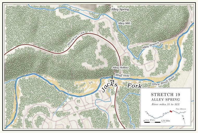
Davis Ford and the campground river front
Ford, shallows and campground · campground on the right bank · about miles 31.3 to 31.4 · Plate A10
The river comes down to Alley through a shallow stretch with a field on one side and the Alley Spring Campground on the other, and the old road crossed it at Davis FordLewis 1980, PDF p. 49, the only source; his map (PDF p. 51) puts Davis Ford above the Alley Bluff Hole and the campground south of the river. Davis Ford lies at the edge of both his maps of the stretch (PDF pp. 47, 51); laid on the river centerline, they put it at about mile 31.2; the place is read from sketch maps and is approximate.. In one family’s telling of a Civil War raid on a Union household upstream, one of the raiders’ wagons broke down “at that first crossing above Alley”Gibson 2000, 32 (the source gives its interviewees pseudonyms); see Chapter 6. (Chapter 6).
The campground spreads over the Bottom. The flat land along a river or creek, built of its deposits and open to its floods. In the 1920s the bottoms near Eminence averaged about a quarter of a mile wide (Chapter 2; Chapter 5). Glossary → on the right bank, upstream of the highwayPlate A10; Lewis 1980, PDF p. 51 (map).. The Park Service built most of it in 1974, and it is the largest campground in the parkNPS 1981; NPS 2022a; see Chapter 11. (Chapter 11). It sits low. When the Gauge. A station of the Geological Survey that records the river’s stage, from which its flow is figured. The Jacks Fork has gauges at Highway 17, Alley and Eminence (Chapter 14). Glossary → at the bridge reads 8 feet, water begins to reach three of its loops, and at 13 feetNational Weather Service (Alley Spring, ALYM7, flood impacts); see Chapter 14, Table 14.4. the whole campground is under water (Chapter 14). On the hillside beside it, old shortleaf pines carry the scars of 39 fires between 1706 and 1915King and Muzika 2014, 79, 84–85 (“adjacent to Alley Spring campground”); see Chapter 16. (Chapter 16).
Alley Bluff Hole
Pool under a bluff · bluff on the left bank · about miles 31.4 to 31.9 · Plate A10
Where the river turns east, a little more than half a mile above the bridge, it runs against a Bluff. A cliff along the river, usually on the outside of a bend, where the river has cut sideways into the hill. In this sense the word was first used in North America (Chapter 2; Chapter 18). Glossary → on the leftthe river centerline (the channel turns from north-northeast to east at about mile 31.4; bridge 32.03); Lewis 1980, PDF pp. 49 (“Just ahead Highway 106 crosses overhead”), 51 (map, “Alley Bluff Hole” lettered on the left where the river turns east below Davis Ford), 52 (“above the bridge”); Jacks Fork Oral History, records SV-15, SV-12 and SV-25 (marked on maps on the left bank at about miles 31.3, 31.6 and 31.8); Plate A10 (left-bank bluff at about 31.9)., and the Pool. A deep, slow stretch of river between riffles (Chapter 16). Glossary → under the bluff is the swimming Hole. Any pool deep enough to swim or fish in, named or not, the basic unit of the river in local speech; also “hole of water” (Chapter 18). Glossary → of Alley. In 1980 it was called the Alley Bluff HoleLewis 1980, PDF pp. 49, 52., and it was already the favorite place to swim, having given “thousands of local swimmers and campers hours of enjoyment.” People who swam it in later years call it Bluff Hole, and so does the park, which keeps a Bluff Hole TrailNPS 2022a, appendix C (Alley Spring trails). and a small river access on the campground sideNRHP, Alley Spring 2023, sec. 7, 3 (the Bluff Hole river access point, with a small gravel lot, in the district’s southwest corner); the place register (Bluff Hole “in Alley Campground”).. A swimmer of the 1970s remembered well-beaten paths to the top of the bluff for jumping and a big sand barJacks Fork Oral History, record SV-15; see Chapter 19. across the water where people watched, and another found the hole “about gone”Jacks Fork Oral History, record SV-17; see Chapter 15. The name Bluff Hole: records SV-12, SV-15, SV-17 and SV-25; see Chapter 18. when she went back (Chapters 15, 18 and 19).
Alley Ford and the Highway 106 bridge
Old ford, highway bridge, gauge and accesses · mile 32.0 · Plate A10
The old Alley Ford crossed just above the present bridge, where the river ran deep, and by one account a ferry worked at Alley from 1906 for several yearsLewis 1980, PDF p. 52, the only source.. Old photographs show a wagon Ford. A place where a road crosses through the water. Many of the river’s fords took the names of the families who lived beside them (Chapter 8). Glossary → and a low-water slabStevens 1991, 174–75 (figs. 44, 45); see Chapter 8. near Alley (Chapter 8). The present steel girder bridge, about 385 feetNational Bridge Inventory (384.8 feet); see Chapter 8. long, went up in 1939–40NRHP, Alley Spring 2023, sec. 7, 12 (reinforced concrete piers)., and it is still the only highway crossing between Highway 17 and Eminence. A footbridge beside it, damaged by the floods of 2017 and 2018, was taken down in 2019NPS 2018; NPS 2019; see Chapter 8. (Chapter 8).
The Geological Survey’s gauge here has measured the river since 1993. It stands above the mouth of the Spring branch. The stream that runs from a spring to the river, such as the branch below Alley Spring (Reach H). Glossary →, so its readings leave out Alley Spring. Its highest mark is 23.29 feet, on April 30, 2017USGS NWIS (07065495); see Chapter 14. (Chapter 14).
Besides the access at Bluff Hole, the park keeps the Alley River Access and the Burr Oak picnic areaNPS 2022a, appendix E; NRHP, Alley Spring 2023, sec. 7, 6, 12. here. A big Gravel bar. A bank of chert gravel and sand, usually on the inside of a bend, bare at low water (Chapter 15; Chapter 18). Glossary → by the bridge has long been Alley’s beach and landing; a paved ramp nearby filled with gravelNPS 1981; see Chapters 11 and 15. (Chapters 11 and 15). Across the river from the park, Harvey Staples, who became Alley’s postmaster in 1942Lewis 1980, PDF p. 53 (Harvey R. Staples). That the postmaster and the founder of Harvey’s are one man is assumed., opened a store and recreation spot. By 1980 Harvey’s was a busy place with a large canoe rental, though by one account Staples did not live to see it payLewis 1980, PDF p. 52, the only source (“The spot became a very profitable enterprise, although Staples failed to live long enough to see it”). (Chapter 11).
Lawrence Hollow
Hollow · right bank · about mile 32.2 · Plate A10
Lawrence Hollow comes in from the south a little below the bridge, and Highway 106 climbs south up its valleyPlate A10. on the way to Eminence. It drains a little more than three square miles, about a square mile and a quarterJacks Fork Creek Network 2026 (Lawrence Hollow, 3.14 sq mi, mouth at about mile 32.2 on the right; Drewell Hollow, 1.21 sq mi, into Lawrence Hollow); Lewis 1980, PDF p. 51 (map). of it through Drewell Hollow, its main Branch. A small creek. The sense is American, on record from 1674 (Chapter 18). Glossary →. Someone who grew up in Eminence calls its creek Denton Hollow Creek, and says it is usually dryJacks Fork Oral History, record SV-15, the only source for the name.. A big spring, the Lawrence Hollow Spring, is said to feed the small branch out of the hollow. The Lawrences, the Drewells and the McCormacks, by one account, were families who once lived in the hollowsLewis 1980, PDF p. 55, the only source. that carry their names.
The deep half mile
Pool · about miles 32.0 to 32.6 · Plate A10
Between the bridge and the mouth of the spring branch the river was once half a mile of deep water, twelve to fourteen feet, and by one account people swam their horses in it. A man named Pulliam from Birch Tree is said to have drowned there in the 1930sLewis 1980, PDF p. 52, the only source.. In later years people swam all along this stretch, from Bluff Hole down to the place where the spring branch comes inJacks Fork Oral History, record SV-15; see Chapter 19. (Chapter 19).
The mouth of the spring branch
Spring branch and creek mouth · left bank · about mile 32.6 · Plate A10
The water of Alley Spring reaches the river by a branch about half a mile longNRHP, Alley Spring 2023, sec. 7, 2; Bowles and others 2011, 6 (about 800 meters); see Chapter 16. that enters on the left. On the federal maps the branch is the last part of Alley Branch, a creek draining about sixteen square milesJacks Fork Creek Network 2026 (16.1 sq mi); USGS GNIS (Alley Branch, 713229). to the north and west. Its valley is Alley HollowNRHP, Alley Spring 2023, sec. 7, 2–3, 5–6; Lewis 1980, PDF pp. 47, 51 (maps); see Alley Hollow and the natural area., and among the side hollows that drain into it are Cartwright, Conner, Kingfisher, Pipestem and Peter Cave hollowsUSGS GNIS (715456, 716201, 720620, 724427, 724251), all draining to Alley Branch on the elevation model; Lewis 1980, PDF p. 55.. Pipestem Hollow, by one account, is named for its shapeLewis 1980, PDF p. 55, the only source., and Peter Cave Hollow is said to take its name from one of the caves where Peter RenfroLewis 1980, PDF p. 55 (“Peter Renfro was to have hidden in Peter Cave”); MSS 1982, 49 (Peter Cave “near Pipestem Hollow” reportedly named for him); see Chapter 13. hid from the law (Chapter 13). Pipestem Hollow is now a state Natural area. A Missouri tract set aside as one of the best remaining examples of the state’s native communities, to be managed to keep it that way. The Jacks Fork and Barn Hollow natural areas were designated on May 27, 1980 (Chapter 11). Glossary → within the Angeline Conservation AreaMDC 2018 (Angeline plan; Pipestem Hollow is one of its three natural areas, with Alley Spring and Spurgeon Hollow). (Reach I).
By one account the branch has entered the river in three or four different places over the years, and the swimming hole at its mouth was a dare, with swimmers going back and forth between the river and the cold spring waterLewis 1980, PDF p. 52, the only source (“Swimming in and out of the cold water was a daring experience”)..
The Spring Branch Trail, about three-tenths of a mile long and laid on bedrockNRHP, Alley Spring 2023, sec. 7, 13; NPS 2022a, appendix C., follows the branch up to the pond. The branch holds the richest plant lifeBowles and Dodd 2016, v, 3–4; see Chapter 16. of the park’s large springs (Chapter 16). In 1926 and 1927 the state made a swimming beach with a beach houseStevens 1991, 182; see Chapter 19. on it (Chapter 19), and four bridges it had recently built over the branch were carried away by a flood, in 1927 or in 1928Perry [1978], sec. 8, 2 (spring 1927, “across the spring branch”); Stevens 1991, 182 (June 1928, “at Alley Spring State Park”); see Chapter 14. by different accounts (Chapter 14). A footbridge across it was destroyed in the flood of 2018, and the road bridge over it was rebuilt in wood in 2019NRHP, Alley Spring 2023, sec. 7, 13 (the Alley Spring Branch Vehicular Bridge, County Road 106-308; the Spring Branch footbridge)..
Alley Spring
Spring and flooded cave · up the spring branch from the left bank · Plate A10
“Just after the bridge,” the park’s river folder of 1977 told floaters, “get out and walk a short way up the spring branch.” The spring rises at the base of a high, concave cliffNPS 1977, Jacks Fork panel (Alley Spring). into a round pool, which the mill dam holds as a pond. Its flow is given as 81 million gallons a dayNPS 1977; NRHP, Alley Spring 2023, sec. 7, 6. and, from the gauge records, about 87 millionUSGS NWIS; see Chapter 12. (Chapter 12). In the early days, by one account, it was a thrill to swim across the springLewis 1980, PDF p. 52, the only source..
The pool is the top of a flooded cave, Alley Spring Cave, whose floor slopes back under the hillLewis 1980, PDF p. 53.. Inside the cave a slope of gravel runs down the west wall to a depth of about 100 feetCarrell, May and Garrison 1980, 26, 32, 67.. Divers have mapped more than 3,000 feet of passage, reaching at least 155 feet below the surfaceMDC, Alley Spring Natural Area. See Chapters 12 and 13., and the water rises under pressureThornberry-Ehrlich 2016, 12–13, after the Ozark Cave Diving Alliance’s map of 2005 (its known western edge is about 100 feet below the pool). from a lower passage (Chapters 12 and 13). In September 1978 divers went 450 feet back and 135 feet down without finding any trace of early people, and from about 100 feet down they saw crayfish that had lost all their color in the dark. The same divers watched the spring turn from a light, milky blue to beige as rain from storms to the northCarrell, May and Garrison 1980, 26, 32; see Chapter 3. came through. The park’s caves have been closed to the public since 2010see Chapter 13 and Part Six. (Chapter 13; Part Six).
The spring has had several names. It was Barksdale SpringBrown 1969, 15; Lewis 1980, PDF p. 53., after its first miller, and Mammoth Spring, the name given for the first mill’s site about 1869Perry [1978], sec. 8 (“Mammoth (now Alley) Spring about 1869”); see Chapter 5. and, by one account, the McCaskills’ nameLewis 1980, PDF p. 53. for it. It became Alley Spring about 1900Lewis 1980, PDF p. 53; Brown 1969, 15, gives 1901., after the post office (see The hamlet, below). By one account the spring stopped for twelve hours in 1811, the year of the New Madrid earthquake, and fell five feet. In 1917, by the same account, it stopped for a few hours when a large Sinkhole. A hollow in the ground where rock below has dissolved or caved in, through which water drains underground; also called a sink, an American use (Chapter 2; Chapter 12). Glossary → opened about fifteen miles to the northwest, and came back muddyLewis 1980, PDF p. 53, the only source..
People camped by the spring for thousands of years before anyone dammed it, and a buried camp of Dalton times lies at the mill (Chapter 3). A Township. A survey square of six miles on a side, holding thirty-six sections; also a division of a county, such as Jack’s Fork Township (Chapter 5). Glossary → plat of 1821 marked an Indian village near the spring, probably Delaware or Shawnee, and archaeologists have looked for itsee Chapter 4 (Price 1992). there (Chapter 4). Someone who grew up in Eminence also remembered a village at the springJacks Fork Oral History, record SV-15..
The millpond and the dam
Millpond and dam · below the spring · Plate A10
The pond covers a little over an acre and is roughly triangular, with several small islands, the largest of them part of the damPerry [1978], sec. 7, 1 (1.047 acres); NRHP, Alley Spring 2023, sec. 7, 6.. The dam, of earth, river rock and concrete, runs about 170 feet east from the mill, and two spillways with wooden gatesNRHP, Alley Spring 2023, sec. 7, 9; Perry [1978], sec. 7, 1. let the water over into the branch. The dirt for it, by one account, was hauled from the side opposite the millLewis 1980, PDF p. 53, the only source..
The first dam stood about a hundred feet below the springPerry [1978], sec. 8., and a flood in the spring of 1890Perry [1978], sec. 8, 1; see Chapter 14. washed much of it away (Chapter 14). When George McCaskill rebuilt the place in 1893–94 he carried a new dam nearly two hundred feetPerry [1978], sec. 8, 1. across the branch, and Robert Brock of Eminence repaired or rebuilt itNRHP, Alley Spring 2023, sec. 8, 24 (“Repairs--or possibly reconstruction--of the mill dam were done around 1894 by Robert Brock, who was from Eminence”). about that time. Late in 1899NRHP, Alley Spring 2023, sec. 8, 24 (the text gives the Current Wave of November 30, 1899; its note 50 cites the issue of April 13, 1899); Lewis 1980, PDF p. 53, gives December 14, 1899. it gave way again. About 1900 Fritz Lahmeyer built a wooden barge to repair it, and by one account the barge sank in the spring and was raised by divers a few years before 1980Lewis 1980, PDF p. 53, the only source.. Floods damaged the dam again in 1903 and 1904NRHP, Alley Spring 2023, sec. 8, 24–25.. The Kansas City company that bought Alley in 1912 paid for a concrete spillway in 1914, and it was gone by 1923Stevens 1991, 162, after Flanders and Morrow 1985.. A flood broke a large Section. A square mile of 640 acres, one thirty-sixth of a township. A quarter section is 160 acres (Chapter 5). Glossary → of the dam and carried off the headgate, in the spring of 1927 by one accountPerry [1978], sec. 8, 2; see Chapter 14. (Chapter 14). The Civilian Conservation Corps rebuilt the dam and its spillways in 1933 and 1934NRHP, Alley Spring 2023, sec. 7, 10., but left a 20-foot section near the east end unrepaired, and by the late 1970s the head of water at the mill was about five feet, enough to turn a stone for demonstrationsPerry [1978], sec. 7, 1..
Alley Mill
Roller mill · west edge of the millpond · Plate A10
The red mill on the pond is the last of a line of mills at the spring. In 1868 the heirs of the pioneer James McCormack sold the land around the spring to Ike Barksdale and John Daugherty, brothers-in-law from Dent County. They dammed the branch and set an Overshot wheel. An upright water wheel fed at the top, turned by the weight of water in its buckets (Chapter 5). Glossary → with an eight-foot fall and eight horsepower under a rough shedPerry [1978], sec. 8 (“a rude shed over the mill stones”). Perry dates the first mill about 1869, Brown 1969, 15, to 1870 (“possibly by William Barksdale”), and NPS, “Alley Mill,” to “by 1868.” to grind corn meal, with a small sawmill run by a steam engine beside it. Barksdale kept a blacksmith shop and a store. In 1874 it was one of only two millsPerry [1978], sec. 8; see Chapter 5. in all of Shannon County (Chapter 5), and in 1879 it ground a thousand bushels of wheat and two thousand of cornLewis 1980, PDF p. 48.. Both families had lost men in the war, by one account, and Daugherty, captured in Shannon County in 1864, became the county’s clerk and recorder in 1867Lewis 1980, PDF p. 48, the only source (Barksdale’s brothers Henry, at Neosho in 1861, and Waller, in Confederate service at Pine Bluff; Daugherty in the Fourth Missouri Volunteer Cavalry, discharged for disability, captured in August 1864 and held at Rolla)..
In 1881 Charles Klepzig, a German immigrant, bought the mill with 240 acresPerry [1978], sec. 8, 1 (Lewis 1980, PDF p. 48, calls him a Prussian).. By one account he also bought a farm of 320 acres across the river, and his children, the only Germans in the neighborhood, never liked the place. After the flood of 1890 he shut the mill (Chapter 14), and the family moved to lower Rocky CreekLewis 1980, PDF p. 48, the only source., in the Current River country. On February 13, 1893, he sold out to George W. McCaskill of Eminence for $1,500Perry [1978], sec. 8, 1; see Chapter 14.. One of his sons, Walter, bought a farm on Rocky Creek in 1912 and rebuilt the small mill on it, which ran until 1930, and the Klepzig Mill there is now kept by the parkNPS 2013 (Klepzig Mill), 22–23 (Walter Klepzig, son of the “Prussian German” Charles Klepzig; Walter moved to another farm in 1925 and left this one to a son, and Walter’s son Claude rented the mill for its last year, 1930). The same report says that McCaskill bought the Alley mill and farm at auction, and that he had bought and sold a farm on Rocky Creek in 1890..
McCaskill and his brother James had already built a Roller mill. A mill that grinds grain between steel rollers. Alley Mill, finished in 1894, is one (Reach H). Glossary → at Summersville, and the machinery for both mills came from the Richmond City Mill WorksPerry [1978], sec. 8, 1. of Indiana. Another brother, John, who built more than twenty mills in the Ozarks, was in charge of the work. The old mill came down in the winter of 1893–94, and the new one was finished in July 1894Lewis 1980, PDF p. 48; NRHP, Alley Spring 2023, sec. 8, 23.. By January 1895 McCaskill was advertising fifty barrelsPerry [1978], sec. 8, 1 (citing the Current Wave, January 3, 1895); Lewis 1980, PDF p. 48, gives a capacity of sixty barrels. a day of “Straight Fancy Roller Process Flour,” with corn meal and chopped feed. Mr. Sprague was the first head miller, and Jim Holloway took over in December 1894Lewis 1980, PDF p. 48..
The building is a frame structure two and a half stories high, about 32 by 42 feet and some 40 feet tall, on a foundation of local Limestone. Calcium carbonate rock formed from lime mud and shells on a sea floor. Most of the limestone laid down here later became dolomite (Chapter 1). Glossary → blocks, sided in pine and roofed with wood shingles. Water from the pond ran through a concrete headrace into a turbine pit under the east porchPerry [1978], sec. 7 and 7, 1., where a Leffel turbine, given as 35 inches and as 46NPS, “Alley Mill” (35); Perry [1978], sec. 7, 1 (46)., still sitsNRHP, Alley Spring 2023, sec. 7, 9.. A wheel on the porch set the gate and so the speed. Belts carried its power up to steel rollersPerry [1978], sec. 7 (a Gray’s Patent Noiseless Roller by Edward P. Allis and Company, Milwaukee, and Mawhood rollers by the Richmond City Mill Works). on the first floor and to sifters above, where flour was shaken through silkNPS, “Alley Mill.”.
It was a merchant mill, built to buy grain and sell flour, larger than mostStevens 1991, 211; NPS, “Alley Mill.” mills on the two rivers and among the most modern in the OzarksPerry [1978], sec. 8, 1.. It was also built to make wheat flour in country that mostly grew cornNPS, “Alley Mill.”. Farmers came several times a year and sometimes waited daysPerry [1978], sec. 8, 1. for their turn, and many paid in grainNPS, “Alley Mill” (the toll).. A miller’s usual share was one-eighth, and by one account Lahmeyer took only a fourteenthLewis 1980, PDF p. 53, the only source.. The mill was “large for its day, but too small to compete in the 20th century,” once store flour from Minneapolis came in cheaper and better roads put Eminence and Summersville within easy reach.
McCaskill did not keep it long. By one account his sister Elizabeth and her infant son were killed by a tornado near Summersville in May 1894, and he lost interestLewis 1980, PDF p. 48, the only source. in Alley. The Boyds bought it in 1895, though some records give 1897Lewis 1980, PDF p. 48 (Ellen J. Boyd, 1895); NRHP, Alley Spring 2023, sec. 8, 24 (A. B. Boyd, 1895); Perry [1978], sec. 8, 2 (Ellen J. Boyd, 1897)., and it passed quickly through other hands: John F. A. Lahmeyer in 1899, A. M. Phillips in 1901 and John M. Knotts in 1902Lewis 1980, PDF p. 48; Stevens 1991, 105 (Knotts, 1902–12). Lewis also lists W. R. L. Blackburn in 1903, which does not fit Knotts’s ten years and is left out.. Knotts sold in 1912 to the Crystal Spring Town-site Company of Kansas City for about $15,000Stevens 1991, 157; Lewis 1980, PDF p. 48.. The mill’s last year of grinding for trade is given as about 1922NRHP, Alley Spring 2023, sec. 8, 20, 26. and as 1927Perry [1978], sec. 8, 2., after a flood.
The Red Mill was white first. Photographs show it white about 1900Perry [1978], sec. 8, n. 12., and in 1913 John LiebingerStevens 1991, 162, after Flanders and Morrow 1985., a stockholder of the Kansas City company, painted the store and the mill white with green trim, helped by the sons of the operator, Taylor Gates. On the inner wall of the mill office he wrote:
Baz the Sucker John Liebinger 1913 Lon the Kid
The same person from Eminence remembered that the mill used to be green and whiteJacks Fork Oral History, record SV-15.. The red came under the state. A photograph of Civilian Conservation Corps men planting trees about 1933–34Stevens 1991, 188 (fig. 52). shows the mill dark red, and a work order of February 28, 1934Perry [1978], sec. 8, n. 12., called for red paint. No historical reasonPerry [1978], sec. 8, 3 (“No historical justification can be found for this choice”). for the color has been found. By 1980 the Park Service was considering painting it white again, though by one account nobody then remembered it white and the Red Mill had become a landmark, and the mill was left redLewis 1980, PDF p. 52, the only source for the objection; the state had it painted red, PDF p. 48..
The Civilian Conservation Corps restored the mill in 1933 and 1934, and in the 1930s the state ran an Ozarks museum inside, grinding with a stone burrPerry [1978], sec. 7, 1; sec. 8, 2. driven by the turbine. The state restored it again in 1958Brown 1969, 62. and replaced the west porch in 1964Perry [1978], sec. 8, 3.. It was listed on the National Register of Historic Places in 1981, repaired in 2014 and put on the back of a quarter in 2017see Chapter 11. (Chapter 11). In the flood of April 2017 about a foot of watersee Chapter 14. stood on its main floor (Chapter 14).
The mill has its ghost stories. The story goes that a man in overalls, carrying a lunch pail, has been seen on the footbridge, and that a phantom campfire has been seen across from the millSteed 2013 (the chapter on Alley Spring Mill), the only source.. In October of 2017 and of 2019 the park held evenings of storytelling at Alley, with Ozark legends and folktales and a skit by the Eminence High School drama club called “The Curse of Healing Spring,” and in 2017 a local musician played old tunes in the millNational Parks Traveler 2017 (Haunting in the Hills; the skit billed as “Curse of Healing Spring,” the tunes played in the mill by a local musician); NPS 2019 (haunted night, October 12)..
The hamlet
Former mill hamlet · around the mill and the spring branch · Plate A10
A photograph taken about 1896 from the bluff above the spring shows the new mill at the water’s edge, a white general storeStevens 1991, 106 (fig. 16); NRHP, Alley Spring 2023, sec. 8, 23–24 (fig. 13; the white building is the Boyd store). in the middle of the view, and houses and outbuildings scattered across open fields beyond. Around the mill grew a mill hamlet: by the 1890s a post office, a general store, a blacksmith shop, a sawmill run off the mill’s turbine and a school. About a dozen people worked in these enterprises, and the school had about twice as many pupilsPerry [1978], sec. 7 (the sawmill shaft), sec. 8 and 8, 2.. Most of the familiessee Chapter 5. who used the hamlet lived on farms around it (Chapter 5).
The post office came first by name. Charles Klepzig applied for it in 1884 and offered two names, Shannon and Alley, and the department took Alley. The name is presumed to honor John Alley, a farmer who lived about three miles east, and every story about why it was chosen appears to be apocryphalPerry [1978], sec. 8, 1; see Chapters 5 and 18. (Chapters 5 and 18). By one account John Alley, oldest son of David Alley, a Tennessean who came in the 1830s, applied for an office on his own farm about two miles southeast of the spring and later moved it to the storeLewis 1980, PDF p. 53, the only source. by the spring. The office’s postmasters followed the mill’s owners until 1912Lewis 1980, PDF p. 53 (Klepzig 1884, McCaskill 1893, Emily Boyd 1895, Lahmeyer 1900, Phillips 1902, Knotts 1903); see Chapter 5., and it became Alley Spring in 1950 (Chapter 5).
Each owner changed the store. The Boyds opened a general store south of the mill in 1895NRHP, Alley Spring 2023, sec. 8, 24.. In 1899 James Smith, who ran the store, moved in a stock bought at InkLewis 1980, PDF p. 53. and advertised “prints, green coffee, granulated sugarStevens 1991, 105 (an 1899 advertisement, James H. Smith). … trace chains and hames.” From 1902 to 1912 John Knotts, a Pennsylvanian who arrived in his late fifties, owned the mill and store, and he paid farmers for their eggs, ham and sorghum in coupon books good at the store, a system borrowed from the lumber company stores. After the big mill at West Eminence opened in 1909 his shelves added sardinesStevens 1991, 105, after Flanders and Morrow 1985., chili, prepared mustard and cereals (Chapter 7).
The Kansas City company of 1912 meant to make Alley a town and a “pleasure resort.” It added a picnic ground with swings and a shelter house, called the casino on early maps, on the east side of the spring branch, with footbridgesNRHP, Alley Spring 2023, sec. 8, 25; McCaskill’s earlier picnic ground by the pond is in Chapter 9. over the water, and the family of its head, Conrad Hug, summered in a camp on the branchStevens 1991, 161.. In 1913 it pulled down the old store and built a two-story one with a boomtown front, with water piped in from the spring branch. The upper floor, meant for a hotel, became a gymnasium for Alley’s young people. A dynamo belted to the mill’s main turbine shaft lit the mill, the store, the school, the dance floor at the picnic ground and two houses, and the lights went on and off when someone threw the dynamo’s clutchStevens 1991, 109, 161–62, after Flanders and Morrow 1985.. A brochure of 1922 still offered Alley as “a summer resort of extraordinary merit,” with rainbow trout in the spring branch, but the resort never grew and the company sold to the statesee Chapter 10. (Chapter 10).
The school was among the first in Shannon County. By one account its ground belonged to the family of Ida Saxton McKinley, wife of the future president, and in 1889 William McKinley and his wife signed a quitclaim deed for it to the Alley School District. In the 1920s Alley briefly had a two-year high school, and in 1930Lewis 1980, PDF p. 52; the McKinley deed rests on this source alone. busing to Eminence began. Church servicesStevens 1991, 123; see Chapter 5. were often held in the schoolhouse (Chapter 5). The one-room Storys Creek School, built in 1896 at Storys Creek east of Alley, now stands between the picnic shelter and the mill, moved there in 1971. By one account Edna StaplesLewis 1980, PDF p. 53 (“between the pavilion and the mill”). bought it for the purpose, and Shannon County people gave it to the parkStevens 1991, 214..
Alley was the county’s gathering place. The Fourth of July picnic drew as many as 2,000 people for popcorn, oranges, peanuts and ice cream, swimming, baseball and dancing, and by one account Moonshine. Whiskey made and sold outside the law. Moonshining was active along the Jacks Fork before, during and after Prohibition (Chapter 13). Glossary → flowed freely in the hills around and the picnics had their fights, one of which ended with a man named Vaughn stabbed to death by his brother-in-law, John Stubblefield. By the same account, the Long Brothers’ CircusLewis 1980, PDF p. 53, the only source. came to Alley in 1900. Someone who went to many of the picnics remembered that people rode their horses in, visited every night and camped three or four days at a time to get their grinding done. At the last picnic this visitor went to, the Gates brothers ran their old steam merry-go-round, thirty minutes for a nickel, and the picnic was “right straight across from the shelter hole, over in that little island … right across the bridge,” with a round bandstand glassed in on every side and a cold-drink standGibson 2000, 46 (a published oral history; the speaker is not named or described; the Gates brothers’ names are real). with no roof. The Odd FellowsStevens 1991, 161; see Chapter 9.’ excursion of 1912 is told in Chapter 9.
Alley Spring State Park
Former state park, 1924–1970 · around the spring and mill · Plate A10
The state bought the spring, the mill and 427 acres in 1924 for $31,500Stevens 1991, 179; Perry [1978], sec. 8, 2; see Chapter 10. (Chapter 10), by one count its fourth state parkLewis 1980, PDF p. 48., though Big Spring, made a state park on October 17, 1924, is also counted as the first. Mac Ellerman, who had overseen the propertyStevens 1991, 179. for the Kansas City company, became the first superintendent, and Noke Jones, a very popular man, ran the park for twenty-four years from 1944, through the years when tourismLewis 1980, PDF p. 48 (the full roll: Ellerman 1924, Alan Drewell 1927, Marion Lawson 1935, Luther Jadwin 1936, Red Omley and Noke Jones 1944, Lloyd Rainbolt 1968). at Alley grew fastest.
In 1926 and 1927 the state cleared away the hamlet’s store, blacksmith shop and spring house and put up a rustic storeStevens 1991, 182; see Chapter 10. of native pine (Chapter 10), and the flood of June 1928 took that storeStevens 1991, 182; Lewis 1980, PDF p. 53; see Chapters 8 and 14. as well (Chapters 8 and 14). Keepers’ houses were built or rebuilt in 1930Stevens 1991, 189..
In 1933 a Civilian Conservation Corps camp, by one account of First World War veteransThornberry-Ehrlich 2016, 6 (“a Civilian Conservation Corps (CCC) work camp for World War I veterans”); Stevens 1991, 189, describes the CCC’s enrollees generally as mostly young men., was set up at Alley. In their first year the men built eleven buildings and two roadsStevens 1991, 189. through the park, laid a new floor in the millNPS, “Civilian Conservation Corps” (which also calls the Alley camp one of many built for First World War veterans). and planted treesStevens 1991, 188 (fig. 52)., and in 1933 and 1934 they added a maintenance shopNRHP, Alley Spring 2023, sec. 7, 8, 10, 15–17., a pump house, seasonal cabins, the rock picnic shelter near the spring and the West Trail. The trail once called the Horse Trail, now the Overlook Trail, about a mile and a half long, climbs to an overlookNRHP, Alley Spring 2023, sec. 7, 14. on top of the bluff above the spring. The present general store went up about 1939 as the park’s office and became a store in 2003NRHP, Alley Spring 2023, sec. 7, 11.. Families still hold their reunionsGibson 2000, 65. there (Chapter 9). The old park’s core, 259 acres, was listed in the National Register of Historic Places as a historic district in 2023NRHP, Alley Spring 2023, 1..
The Park Service took Alley in 1970Perry [1978], sec. 8, 3; see Chapter 10. and remade much of it again (Chapter 11). By one account of 1980, most people thought the federal remodeling had destroyed the park, a project marked by poor planning, wasteful spending and too much asphaltLewis 1980, PDF p. 52.. Around 2000 Shannon County people remembered the mill fondly from the state park years and wanted it grinding again, with the whiskey exhibit and the schoolGibson 2000, 144..
Alley Hollow and the natural area
Hollow and natural area · left bank, from the river up past the spring · Plate A10
Alley Hollow is the valley of Alley Branch. Its flat, open floor holds the spring, the millpond, the mill and most of the old park’s buildings, with the river’s gravel bank along its southern edge, and above the spring the hollow runs on to the northwestLewis 1980, PDF pp. 47, 51 (maps, Alley Hollow lettered up the creek northwest of the mill); Jacks Fork Creek Network 2026 (Alley Branch, with Conner and Cartwright hollows along it). The name is not in the federal names file (USGS GNIS)., its creek coming down to feed the spring branch from the northNRHP, Alley Spring 2023, sec. 7, 2–3, 5–6 (“a flat, open valley called Alley Hollow”; “Alley Hollow Creek, which feeds the spring branch from the north”; the Alley Hollow area “includes the floodplain associated with the two creeks, as well as Alley Spring and the mill pond,” and “The gravel riverbank of the Jacks Fork River runs along the southern edge of the area”).. Highway 106 runs north from the bridge along the west side of the hollow before it turns west to climb the ridgeNRHP, Alley Spring 2023, sec. 7, 6 (“runs north-south along the western side of Alley Hollow,” then “curves to the west, exiting the district near the top of a ridge”)., and the road from Eminence to Summersville once went on up the hollowLewis 1980, PDF p. 52, the only source.. By one account several families farmed in the hollow until the flood of 1928 turned their farms into gravel bars, and Joe Chilton’s truck, parked a quarter mile up the hollow, washed down into the spring branch. Another flood came down the hollow on February 9, 1966, and by the same account a storm in April 1974 drowned three people in a camperLewis 1980, PDF pp. 52–53, the only source. at the hollow’s mouth.
In 2007 the state designated 795 acres at the spring as the Alley Spring Natural Area, owned by the Park Service and managed with the state. At least seven animals that live only in caves, the grotto salamander among them, have been found in the cave passages beneath it, and Branson Cave is counted among the most biologically diverseMDC, Alley Spring Natural Area; see Chapter 13. caves in Missouri. Like the park’s other caves it has been closed to the public since 2010see Chapter 13 and Part Six. (Chapter 13; Part Six). The grotto salamander begins life in cave streams and spring runs as a brown or dark gray larva with gills, working eyes and a broad tail fin. After two or three years, sometimes six, it loses its gills and turns pale tan or pink, and its small eyes are partly or wholly covered by the lids. Grown, it is three to five inches long and lives at least nine years, and it is commonest in caves with many batsMDC, “Grotto Salamander.”, whose droppings feed the small animals it eats.