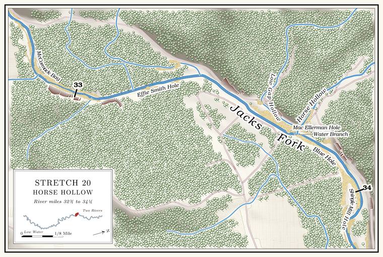
McCormack Bay and the hollows below
Bay, spring and hollows · right bank · about miles 32.8 to 33.0 · Plate A10
Below the Spring branch. The stream that runs from a spring to the river, such as the branch below Alley Spring (Reach H). Glossary → the river runs east, and McCormack Hollow comes in on the right at about mile 32.8, draining a little over a square mileJacks Fork Creek Network 2026 (1.19 sq mi); USGS GNIS (McCormack Hollow, 722058).. Graveyard HollowLewis 1980, PDF p. 55. runs into McCormack Hollow near the Alley Spring Cemetery, which stands on a bench above the river. Its oldest stone is that of James L. Day, who died on August 22, 1879, at twenty-two, and it holds about 150 graves of Alley families. The Barksdales were buried there too, and later moved to Dent CountyLewis 1980, PDF p. 52.. Matthew Columbus “Mac” Ellerman (1877–1945), probably the state park’s first superintendentShannon County cemetery readings (Alley Spring Cemetery: James L. Day, December 10, 1856–August 22, 1879; Matthew Columbus “Mac” Ellerman, January 8, 1877–December 12, 1945). That he is the Mac Ellerman of the state park is an inference from the name; the readings do not say so., is buried there.
The McCormacks were the first family to hold the land at Alley. By one account Samuel McCormack, then in his sixties, brought his family to the country in the early 1820s and settled on Spring Valley with three sons, and the eldest, James, took up the land around the spring, though he did not get a clear deed to it until January 15, 1858. Mary McCormack, called Polly (1838–1912), who married George Franklin Chilton, was by one family record the daughter of a James McCormack, probably this oneShannon County cemetery readings (Old Eminence Cemetery: Mary “Polly” McCormack Chilton, December 15, 1838–September 1, 1912, with the compiler’s note “Daughter of James McCormack & Elizabeth”). That her father is the James McCormack of Alley is an inference; the readings do not say so.. A man named James TackettLewis 1980, PDF p. 48, the only source; James McCormack probably came in the 1820s, Stevens 1991, 27 (see Chapter 5). was supposed to have been at Alley first, but never filed a claim. The family is said to have kept a hand-dug well by the house and a spring house at McCormack Spring, and the spring fed McCormack Bay, on the right bank, which was a favorite place to ice-skateLewis 1980, PDF p. 55, the only source; his map (PDF p. 51) puts the bay and the spring on the right bank.. The Widow McCormick’s, where a Union patrol camped in November 1863 and burned the buildingsOR, vol. 22, pt. 1, 746–47; see Chapter 6. That it was the McCormack place at Alley is an inference from the name and the distance, ten miles down the Jacks Fork from the Stephens house; the report does not place it. the next morning, may have been this family’s place (Chapter 6).
Effie Smith Hollow and Hole
Hollow, ford and pool · left bank (hollow) · about miles 33.1 to 33.4 · Plate A11
Effie Smith lived near the mouth of the hollow that carries her name, and the short, unnamed hollow of a little less than a square mile that comes in on the left at about mile 33.3 is probably itJacks Fork Creek Network 2026 (0.95 square miles, mouth at 33.30, left); the 1980 map draws Effie Smith Hollow from the northwest to the river below McCormack Bay, and the channel at 33.30 is the only one that fits.. Effie Smith Ford crossed the river near the mouth, and Effie Smith Hole lies beside it. By one account Bill King drowned at the Hole. Any pool deep enough to swim or fish in, named or not, the basic unit of the river in local speech; also “hole of water” (Chapter 18). Glossary →. The river was in flood when he tried to cross, he was swept downriver, and he was found in a field downstream eleven days laterLewis 1980, PDF p. 55, the only source. The source says he was found “in the Culpepper field.”.
Across the river lies the Gregory PlaceLewis 1980, PDF p. 55, the only source; trail riding in the park: see Chapter 11.. By 1980 Ralph Branson, and after him Jim and Jane Smith, hosted the Eminence Trail Rides there, a large ride each June and another each August that brought several hundred riders from Missouri and the states around it (Chapter 11). By the same account, two elderly women, Bethie and Lillie Gregory, lived on the place in the 1930s. Two men, Shedd and Tripp, came to rob them wearing Halloween masks. When one of the women pulled the mask off one of them, the men struck the women on the head and burned the house, and Sheriff Freeman Powell caught them three days later.
Low Gap Hollow and Mac Ellerman Hole
Hollow and pool · left bank · about mile 33.6 · Plate A11
Low Gap Hollow is a short valley of a little over a square mileJacks Fork Creek Network 2026 (Low Gap Hollow, 1.22 square miles, mouth at 33.55, left; Water Branch at 33.77); USGS GNIS (Low Gap Hollow, valley, falls at 33.59). that comes in on the left a few hundred yards above the mouth of Horse Hollow, so that two side valleys reach the river close together. Mack Ellerman lived near its mouthLewis 1980, PDF p. 55., and the Pool. A deep, slow stretch of river between riffles (Chapter 16). Glossary → beside it is Mac Ellerman HoleLewis 1980, PDF p. 51 (map, “Mac Ellerman Hole”); Plate A11.. He was probably the Mac Ellerman who ran Alley for the Kansas City company and became the first superintendentan inference from the name; see Reach H (Stevens 1991, 179; Lewis 1980, PDF p. 48). of the state park there (Reach H).
Horse Hollow and Water Branch
Hollow, creek and ford · left bank · about mile 33.8 · Plate A11
Horse Hollow is the largest side valley on this stretch. Its creek, Water Branch on the federal maps, comes down Angeline Hollow and Horse Hollow from the north and drains about eleven square miles. Sinking Branch joins it out of Keeling Hollow, and Hines HollowJacks Fork Creek Network 2026 (Water Branch, 11.02 square miles, mouth at 33.77, left; Sinking Branch, down Keeling Hollow, 4.18; Hines Hollow, 1.95); USGS GNIS (Water Branch, stream; Horse Hollow, valley). comes in from the side. The hollow is said to take its name from John Alley’s horses, which he kept there and which raiders came to steal during the Civil WarO’Brien 1939, 62; see Chapter 6. (Chapter 6). Horse Hollow FordLewis 1980, PDF p. 51 (map). crossed the river near the mouth.
The Strains, Bells and RussellsLewis 1980, PDF p. 55, the only source. were among the families who lived in the hollow, and by one account the big flood of 1928 washed most of their farms away. In 1895, by the same account, a flood on Horse Hollow got the creek “so big it cut the river off” and washed away Sue Plowman’s house above the Culpepper Place. By 1980 the creek ran only in wet weather. In the dry months water stood in places along it without running, and it is said to have run all the time once.
The logging railroad climbed the hollow from the riverStevens 1991, 90; see Chapter 7. (Chapter 7). By one account a track also ran on up the river into Alley Hollow in 1907 and was later torn out, and the main line climbed Horse Hollow past Angeline and over the Flat Woods toward Spring ValleyLewis 1980, PDF pp. 52 (“In 1907 a tram was built up the river and into Alley Hollow,” after an earlier tram to Horse Hollow), 56, the only source.. By the same account a crew was laying track in the upper hollow when a car loaded with steel broke loose on the Grade. The slope at which a river carries its load without cutting down or building up (Chapter 2). Glossary → and hit Engine Number Two head-on. The boiler burst and scalded Bud Suesbury to death, and the place became Suesbury Curve. John Taylor was killed in the hollow trying to stop a string of runaway cars loaded with logs, when the cars left the track and the logs buriedLewis 1980, PDF p. 55, the only source. The source puts the wreck “on West Main in upper Horse Hollow.” him.
Angeline
Logging camp, site · up Horse Hollow · Plate A11
Angeline was the Missouri Lumber and Mining Company’s big logging camp up Horse Hollow (Chapter 7). Its post office opened in 1909 or 1910 and closed in 1929, when the mail went to AlleyLewis 1980, PDF p. 55, which also lists the postmasters., and two stories explain its namesee Chapter 5 (Forte, Postal History; O’Brien 1939, 3). (Chapter 5). The Angeline school ran for many years after the logging daysLewis 1980, PDF p. 55.. A woman who retired after forty-two years of teaching in Shannon County schools remembered going to the Storys Creek school as a child and teaching the Angeline school while she was a high-school sophomoreGibson 2000, 44 (the source spells it “Story’s Creek School”)..
The camp stood in Horse HollowStevens 1991, 90 (“In Horse Hollow, the company built a logging camp named Angeline”); Lewis 1980, PDF p. 56 (“The main line continued up Horse Hollow past Angeline”).. Above the mouths of Sinking Branch and Hines Hollow, a little more than a mile up, the federal maps call the valley Angeline Hollow, and the camp may have stood thereUSGS GNIS (Angeline Hollow, valley, 713298, whose lower end lies beside the mouths of Sinking Branch and Hines Hollow, about two kilometers from the river); Jacks Fork Creek Network 2026 (Water Branch, Sinking Branch and Hines Hollow).. An Eminence resident who has done park work placed it lower, not far above the river; of two others who know the river, one did not know the name and one had heard it but could not place itJacks Fork Oral History, records SV-12 (marked on a map about 270 meters north of the river near the mouth of Horse Hollow, at about mile 33.9), SV-20 (“Doesn’t know it”) and SV-17 (“Heard of it, not sure where”); the Angeline School was “near Alley” in 1939 (O’Brien 1939, 3)..
The Blue Hole and Shingle Mill Hole
Pools · about miles 33.8 to 34.1 · Plate A11
The Blue Hole is the Bluff. A cliff along the river, usually on the outside of a bend, where the river has cut sideways into the hill. In this sense the word was first used in North America (Chapter 2; Chapter 18). Glossary → hole below the mouth of Horse Hollow, one of several pools of that namesee Chapter 18. on the river (Chapter 18). A shingle millLewis 1980, PDF p. 54; maps PDF pp. 51, 57 (Shingle Mill Hollow from the north). stood at the mouth of Shingle Mill Hollow, a short hollow on the left a little below, and the hole at its mouth carries the mill’s name.