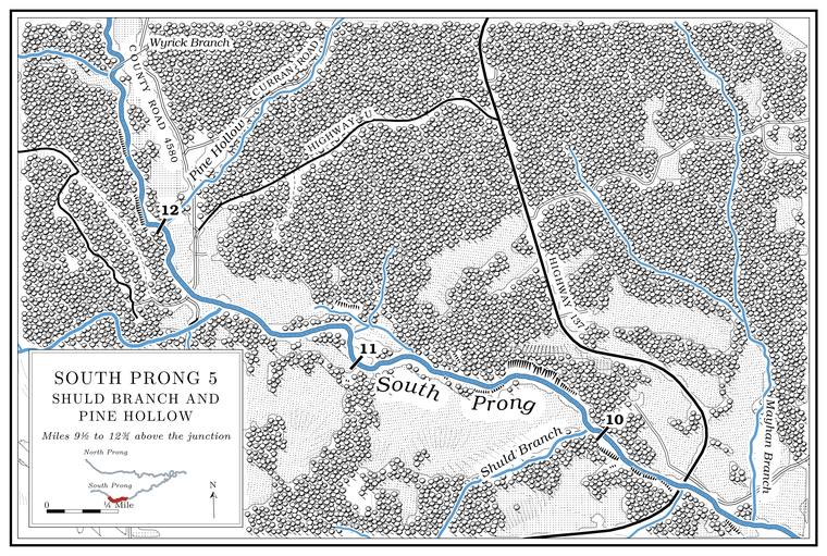
Wyrick Branch, with Brewer, Holden and Nigman branches
Branch · right bank · South Prong mile 12.6 · Plates A1, A15
Wyrick Branch comes in from the northwest after a run of a little over two miles, draining about three square miles. Its two Forks, the. The North and South Prongs and their junction, where the Jacks Fork begins; also called the Prongs (Chapter 18). Glossary →, Nigman Branch from the north and Brewer Branch from the west, meet to form it, and Holden Branch is a separate Branch. A small creek. The sense is American, on record from 1674 (Chapter 18). Glossary → from the west lower down. All three names are printed on the 1948 Clear Springs topographic map, and the lower stream and its north fork also go together under the name Wyrick/Nigman Branch. None of the names has been explained. The Prong. A branch or arm of a creek, set down in 1860 as Southern usage. The North and South Prongs join to form the Jacks Fork (Chapter 18). Glossary → holds permanent Pool. A deep, slow stretch of river between riffles (Chapter 16). Glossary → up to about this point. Above it two small unnamed branches come in from the northeast.
Pine Hollow
Hollow · left bank · about South Prong mile 12.0 · Plates A1, A15
Pine Hollow is a short hollow from the northeast, about a mile and a quarter long, draining about a square mileJacks Fork Creek Network 2026.. Nothing is recorded of the name. The watershed has another Pine HollowUSGS GNIS; see Chapter 18. in the Mahans Creek drainage (Chapter 18). In 1948 New Liberty SchoolUSGS 1948 (Clear Springs), at about 37.107, −91.900. stood beside the prong near the mouths of Pine Hollow and Wyrick Branch.
The nameless creek and Varvol
Creek and former post office · right bank · about South Prong mile 11.5 · Plate A15
A creek from the west comes in less than half a mile below Pine Hollow. It runs nearly six miles back toward Cabool, drains nearly thirteen square miles and is the largest creek in the watershed without a recorded name (Chapter 18). Streams are ranked by order. Two headwater branches with no tributaries of their own, first-order streams, join to make a second-order stream, two of those make a third-ordergeneral explanation of stream order, the ranking used in the state’s 2001 stream tables (MDC 2001, PDF 30–31). one, and so on down. This creek is very likely the unnamed fourth-order tributary, 6.7 miles long, that in 2001 lacked a forested corridor along more than three-fifthsMDC 2001, PDF 30 (table Ge03, JFW010), 31, 107 (table Hc04, 62.7 percent). of its length, and below it the prong is a fifth-order streamMDC 2001, PDF 30–31. The identification of JFW010 with this creek is an inference from its order, length and quadrangle..
Near its head is Varvol, where Highway HHNational Bridge Inventory (structure 6857, “RT HH S over JACKS FORK RVR”). crosses the creek on a short concrete culvert of 1956. On the federal bridge list the culvert carries the highway over the “Jacks Fork River,” so whoever entered it there probably took this creek for the head of the prong. The Varvol post office ran from 1892 to 1904 (its dates are also given as 1891 to 1909, with the spelling VarvelForte, Postal History, Texas County (Varvel).). It was named for a family who kept the office in their general store, and a Varvol SchoolO’Brien 1939, 137. took the post office’s name. Varvol lies in Sargent Township, which took its name in 1917 from the village of Sargent to the west, first called Stogsdill after its storekeeper and renamed by the railroadO’Brien 1939, 118, 127. for one of its officials.
Shuld Branch
Branch · right bank · South Prong mile 10.1 · Plates A1, A15
Shuld Branch, a name nobody has explained, comes in from the southwest, a little over two miles long and draining about two square milesJacks Fork Creek Network 2026.. It enters less than half a mile above the Route 137 bridge and runs water only part of the yearLewis 1980, PDF 6 (“runs water part of the year”); MDC 2001, PDF 91 (class C, 2.0 miles: may stop flowing in dry weather)..
Route 137 bridge
Bridge · about South Prong mile 9.7 · Plates A1, A15
Route 137 runs north from Willow Springs and crosses the South Prong between its junctions with Routes U and AZMoDOT 2025.. The single-lane steel girder bridge of 1932National Bridge Inventory (structure 8749, “MO 137 S over S FK JACKS FK RVR”). stood here until the state closed the road in the summer of 2025 to replace itMoDOT 2025; see Chapter 8. (Chapter 8). The highway was a gravel road within living memory, kept up with gravel dug from the creeksJacobson and Primm 1994, 52; see Chapter 15. (Chapter 15).