Mayhan Branch
Branch · left bank · South Prong mile 9.3 · Plates A1, A15
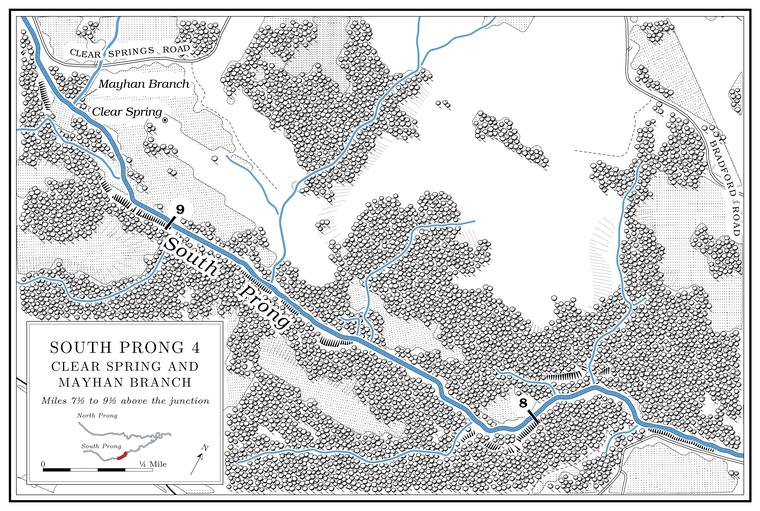
Mayhan Branch comes in from the north a short way below the bridge, a Branch. A small creek. The sense is American, on record from 1674 (Chapter 18). Glossary → of about a mile and a half draining nearly two square miles that heads close to Clear SpringsJacks Fork Creek Network 2026. village. The name, also spelled Mahan and Mayhen, comes from Henry and Debarieth Mahan. Henry came up from Mahans Creek, far down the Jacks Fork, about 1850 and settled here, and Larkin StoryLewis 1980, PDF 6 (Mahan Branch), the only source for the name’s origin; MDC 2001, PDF 90 (Mayhen).’s family settled nearby. The branch may stop flowingMDC 2001, PDF 90 (class C, 1.3 miles). in dry weather.
Clear Spring and Clear Springs
Spring and village · left bank · about South Prong mile 9.2 · Plates A1, A15
Clear Spring rises on the north bank a short way below the mouth of Mayhan Branch, about half a mile below the Route 137 bridgeLewis 1980, PDF 7 (map); USGS 1948 (Clear Springs)., and its run to the river is about a tenth of a mileMDC 2001, PDF 90 (table Wq01, class P, 0.1 mile). long. It is named for the clearness of its Pool. A deep, slow stretch of river between riffles (Chapter 16). Glossary →O’Brien 1939, 28 (“the crystal-like quality of the spring pool”).. Its flow has been measured at between 0.78 and 1.15 cubic feet a secondMDNR, “Springs” (Clear Spring, Texas County, record 2150008: 350.1 to 516.1 gallons a minute, undated; converted). MDC 2001, PDF 27 (table Ge02, after Vineyard and Feder 1974), prints 1.41, probably Big Spring’s figure carried down a line., and it has also been put at about half a million gallons a day, close to the lower figureLewis 1980, PDF 6 (about 347 gallons a minute). (Chapter 12).
The village took its name from the spring. It had a post office from 1880, spelled Clearspring from 1897 to 1910O’Brien 1939, 28 (“the unusually fine spring in the vicinity”)., until 1953, when the mail went to Willow Springs; the office’s dates are given as July 12, 1880, to October 29, 1953Rowe 2008 (Clear Springs: Nardon Cross, July 12, 1880; Theodore Cross, November 24, 1885; discontinued October 29, 1953); Forte, Postal History, Texas County (1880–1953). Rowe’s days are those of the first appointment and the discontinuance; Lewis’s months (next note) may mark when the office opened and closed in practice., and as August 1880 to December 1953. Among its keepers was a Theodore A. Cross in 1885. The old village and its post office stood by the spring, and Clear Springs School, named for the villageO’Brien 1939, 28., was on the hill nearbyLewis 1980, PDF 6 (the office “closer to the spring”; the school “nearby on the hill”).. The 1948 topographic map still letters Clear Springs beside the springUSGS 1948 (Clear Springs), at about 37.095, −91.847., a little north of the Prong. A branch or arm of a creek, set down in 1860 as Southern usage. The North and South Prongs join to form the Jacks Fork (Chapter 18). Glossary →. The present community lies about a mile to the north, on Route YUSGS GNIS, Clear Springs (populated place), about 0.9 mile from the spring. a mile east of Route 137.