Panther Hollow and Panther Hollow Shoal
Hollow and riffle · right bank · about mile 6.2 · Plate A3
Panther Hollow, the last named hollow above Highway 17, heads in Howell County and drains a little over four square milesJacks Fork Creek Network 2026 (4.34 square miles).. It is said to have been named for the panthersPottenger 1945, Howell file p. 81; see Chapter 18. that lived there in the early days (Chapter 18). Mountain lions, the panthers of the old accounts, were all but wiped out in Missouri in the nineteenth century. The last native one known was killed in 1927, and none was confirmed in the state again until December 1994, when raccoon hunters shot one near Peck Ranch in Carter CountyHamilton 2006.. A spring enters the river nearby from a dripping Bluff. A cliff along the river, usually on the outside of a bend, where the river has cut sideways into the hill. In this sense the word was first used in North America (Chapter 2; Chapter 18). Glossary →. The Riffle. A fast, shallow, rocky stretch between pools. The riffles are the gardens of the riverbed: in July a square meter of riffle produced more than six times as much as a square meter of pool (Chapter 16). Glossary → beside the mouth of the hollow is Panther Hollow ShoalLewis 1980, PDF p. 24 (map)., where rough rocks are said to block a boat’s way at Low Water. The local name for the Highway Y bridge over the South Prong, the access beside it and the county’s low-water crossing where the prongs meet, and so for the head of the river (Chapter 8; Chapter 18). Glossary →Lewis 1980, PDF p. 19, the only source.. A Mountain View resident who grew up on this stretch named the Shoal. A fast, shallow, rocky stretch between pools; a riffle. Suckers crowd onto the shoals in spring, and the old saying is that “the dogwoods bloom when the suckers are shoaling” (Chapter 18; Chapter 19). Glossary → at Panther Hollow as the hardest spot on the river to get throughJacks Fork Oral History, record SV-20..
River Hill and the Old Quarry
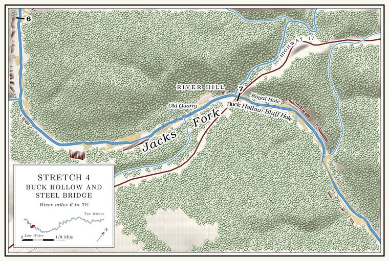
Highway hill and quarry · at the Highway 17 bridge · about miles 6.7 to 7.0 · Plate A3
Highway 17 comes down to the river on River Hill, a name that no map prints and that probably belongs to the descent on the Mountain View sidean inference. The people who call the descent River Hill are mostly from Mountain View, south of the river, and one person from Arroll calls it “South 17” (Jacks Fork Oral History, records SV-03, SV-09, SV-19, SV-20, SV-23); Plate A3 letters River Hill south of the river; the 1980 map letters the road hill on the north side Buck Hollow Hill (Lewis 1980, PDF p. 24). No record states the side. (Chapter 18). The steep Highway 17 Grade. The slope at which a river carries its load without cutting down or building up (Chapter 2). Glossary → at Buck Hollow are said to have caused a number of accidents and deaths. The Old Quarry lies on the right bank just above the bridgeLewis 1980, PDF p. 24 (map: the quarry symbol south of the river, between the channel and the highway, just upstream of the bridge); Plate A3., where Vernon Campbell is said to have run a lime quarry and hauled out Limestone. Calcium carbonate rock formed from lime mud and shells on a sea floor. Most of the limestone laid down here later became dolomite (Chapter 1). Glossary → until the mid-1950sLewis 1980, PDF pp. 19, 24 (map), the only source..
Steel Bridge
Bridge, landing and gauge · mile 7.0 · Plate A4; Fig. 21
Highway 17 comes down River Hill (Reach C) and crosses the river 3.6 miles north of Mountain ViewMDC, Jacks Fork Natural Area.. The sign calls the crossing Buck Hollow, floaters say 17 or the 17 Bridge, and Mountain View says Steel Bridge; how one crossing came to carry so many names is told in Chapter 18. Buck Hollow Ford took the road between Mountain View and Summersville across the river’s rock Bottom. The flat land along a river or creek, built of its deposits and open to its floods. In the 1920s the bottoms near Eminence averaged about a quarter of a mile wide (Chapter 2; Chapter 5). Glossary → before the Civil War, and the county’s bridge of 1913–14see Chapter 8. The 1980 account dates a steel bridge here “about 1918” and says freight wagons would not use the narrow bridge because the horses were afraid to cross it (Lewis 1980, PDF p. 19); the contract of June 1913 and the bridge’s use by February 1915, reported in the Mountain View Standard (see Chapter 8), put the bridge earlier. replaced it. The Ford. A place where a road crosses through the water. Many of the river’s fords took the names of the families who lived beside them (Chapter 8). Glossary →, the fight over where the bridge should go and the bridges since are the subject of Chapter 8. The present bridge dates from 2005National Bridge Inventory (MO 17 over the Jacks Fork, built 2005).. The Buck Hollowsee Chapter 18 (Jacks Fork Oral History, records SV-03, SV-05, SV-06, SV-20 and others). landing, with parking and a short river trailNPS 2022a, appendix tables., lies a little below it on the south bank, and the bridge has been the usual Put-in, take-out. The places where a float begins and ends (Chapter 20). Glossary → for the upper river for about a centuryNPS 1977; see Chapters 9, 11 and 20. (Chapters 9, 11 and 20).
The Pool. A deep, slow stretch of river between riffles (Chapter 16). Glossary → at the bridge is Buck Hollow Bluff Hole, long a favorite place for families from Summersville and Mountain View to swim and picnicLewis 1980, PDF p. 19; see Reach C. (Reach C). Swimmers went in from the Gravel bar. A bank of chert gravel and sand, usually on the inside of a bend, bare at low water (Chapter 15; Chapter 18). Glossary → at the foot of the hill and swam along the bluffJacks Fork Oral History, record SV-20. The swimmer of record SV-06 also swam the hole by the bridge, every summer day of 1984 to 1986, and marked its deepest water beside the crossing; see Chapters 15 and 19. (Chapters 15 and 19). For years gravel was dug from the pool after floodsJacobson and Primm 1994, 52; see Chapter 15.. In the aerial photographs of 1995 to 2026 the channel under the bridge and around the bend to the landing has not moved, while the gravel bars beside the bridge and at the landing have grown and the open water between them has narrowedFig. 21, traced from dated aerial imagery, 1995–2026; see Chapter 15. (Fig. 21; Chapter 15). Immediately below the bridge a swift, narrow, rocky Chute. A narrow, fast slot of water through a shoal or past an obstacle. A smooth V of water pointing downstream marks the deepest path through it (Chapter 20). Glossary → is said to claim a lot of canoesLewis 1980, PDF p. 19, the only source..
Gauge. A station of the Geological Survey that records the river’s stage, from which its flow is figured. The Jacks Fork has gauges at Highway 17, Alley and Eminence (Chapter 14). Glossary → 07065200, “Jacks Fork near Mountain View,” has stood at the bridge since February 2000Wilson 2001, 2. and has recorded the river’s flow since October 2001USGS NWIS, gauge 07065200.. Its readings are the usual measure of the water on the upper river, and its record is the subject of Chapter 14. With little spring water to steady it, the river here warms and cools with the air. In 2012 it ranged from about 36 °F to about 90 °F, the widest rangeWesthoff and Paukert 2014, 5; see Chapter 16. of any site measured in the riverways that year (Chapter 16).
Buck Hollow and Roadside Spring Cave
Hollow, creek and spring cave · left bank · mile 7.0
The landing and the bridge take their name from a real hollow. Buck Hollow comes in from the north at the bridge, carrying a creek that runs about two and a half miles and drains about two and a half square milesJacks Fork Creek Network 2026 (2.55 square miles; 4.24 kilometers)., the largest side stream in the reach (Table D.1). The Stallman School stood near its head. Two miles beyond, across the flat, is Oakside, whose post office opened on March 29, 1890, with John L. C. Richards as postmaster, and whose church has a large cemeteryLewis 1980, PDF p. 19, the only source. beside it.
Near the mouth of the hollow, about 500 feet from the river, is a spring, Roadside Spring Cave. On December 29, 1980, it was the only water in the hollow’s stream, coming out of a thin ledge of Dolomite. Calcium magnesium carbonate rock, a close relative of limestone, formed from lime mud on the floor of a warm, shallow sea. Nearly every bluff on the Jacks Fork is dolomite (Chapter 1). Glossary → at about 850 feet of elevation at about a quarter of a cubic foot a second. From the highway the opening looks about thirty feet wide and two or three feet high, too low to enter. The real entrance may have been missed, or the name may belong to another cave recorded in the wrong placeMSS 1982, 52 (the visiting cavers’ own doubt). (Chapter 13).
Camp Witbeck, Cardinal Acres and Whitbeck Hole
Former resort and pool · right bank, below the bridge · Whitbeck Hole about mile 7.2
The cabins of Camp Witbeck, renamed Cardinal Acres in 1941, stood in a row on a narrow Terrace. A level bench above a river, the remains of an older floodplain left high when the river cut down (Chapter 2). Glossary → on the south bank a little below the bridge, each with a view of the riverNPS 2013, 33, 48–51.. The resort’s history, from its opening in the early 1920s to the sale of 600 acres around the bridge to the United States in 1969, is told in Chapter 9. What remains is a cultural landscape of 5.4 acres, the largest group of cabins and cabin ruins the government owns anywhere in the riverways. In 2013 two cabins and two privies still stood among stone foundations, a seven-foot chimney, cisterns, the foundation of a pumphouse and old retaining walls, and daffodils and irisesNPS 2013. from the resort years still came up along the walls in spring. A Mountain View resident who does not remember the resort has walked up the path and explored the old cabinsJacks Fork Oral History, record SV-20..
Below the cabins, where the river bends back to the southeast at about mile 7.2Lewis 1980, PDF p. 19 (Buck Hollow Bluff Hole, then the chute below the bridge, then the cabins, then Whitbeck Hole) and the map on PDF p. 24 (Buck Hollow Bluff Hole lettered above the bridge, Whitbeck Hole at the top of the bend below it), measured on the river centerline., a small pool rimmed by a rocky bluff on the left has been called Whitbeck HoleLewis 1980, PDF p. 19, the only source; lettered Whitbeck Hole on his map (PDF p. 24).. It is a separate pool from Buck Hollow Bluff Hole at the bridge. The camp’s bluff was a jumping placeWehmer 2024; see Chapter 19. (Chapter 19), probably the bluff at the bridge poolan inference from Wehmer’s name for the bluff, Buck Hollow Bluff, which is the 1980 name of the bridge pool (Lewis 1980, PDF pp. 19, 24); Wehmer does not say which pool., which a Howell County man called Buck Hollow Bluff. His wife’s family spent every Fourth of July at Buck Hollow from the 1970s onWehmer 2024 (“a nice pool of water with a shallow bank leading out to a nice bluff”).; he was there for almost fifty of them and saw hundreds of people jump from the bluff.