Royal Hole
Pool · about mile 7.5 · Plate A4
The Pool. A deep, slow stretch of river between riffles (Chapter 16). Glossary → known as Royal HoleLewis 1980, PDF p. 19, the only source; lettered on his map between the bridge and Lily Pad Hole, PDF p. 24., a short way below Whitbeck HoleLewis 1980, PDF p. 19 (text order) and the map on PDF p. 24 (Royal Hole lettered on the right where the river runs southeast from the bend at Whitbeck Hole, above the springs and Lily Pad Hole), measured on the river centerline., is marked by backwater and rocks on the right. Wild goats, once common along the Current and the Jacks Fork, still lived near it around 1980. Royal Hole was on the park’s list of primitive campsites in 1981NPS 1981, 127 (the first Jacks Fork site on the list, ahead of McCubbin Spring and Baptizing Hole)., and a short park road carries its nameNPS 2022a, PDF 262 (Royal Hole Road, NPS 789, 0.06 mile, map 10); map 10 sets NPS 789 by State Highway 17, just above Buck Hollow River Access.. A resident who came to Mountain View from Oklahoma in 1979Jacks Fork Oral History, record SV-05 (marked on a map); see Reach C and Chapter 18. marked a pool a little below the bridge as Blue Hole, one of several on the upper river to carry that name (Reach C; Chapter 18).
The unnamed branch and the mussel bed
Side branch and riffles · left bank · about miles 7.6 to 8.4
A little over half a mile below the bridge the next creek of any size comes in from the north, draining about three-quarters of a square mileJacks Fork Creek Network 2026 (0.76 square miles).. It has no recorded name.
Between that Branch. A small creek. The sense is American, on record from 1674 (Chapter 18). Glossary → and McCubbin Hollow lay the richest Mussel. A freshwater clam that lives half-buried in the riverbed and filters its food from the water. Mussels on the Jacks Fork fell sharply between the surveys of 1982 and 2017–19 (Chapter 16). Glossary → site found anywhere in the riverways in 2023–24. Six species were found there, five of them alive, more than at any other site in the park, among them the purple lilliputWesthoff, Laszlo and Huggins 2026, appendix E, table 12., a small mussel critically imperiled in Missouri, whose larvae are known to grow on green and longear sunfishMDC, MOFWIS, “Purple Lilliput” (glochidial hosts Lepomis cyanellus and L. megalotis; state rank S1, global rank G2).. At a site near the bridge first searched in 1982, finding nineteen live mussels in 2017–19 took longerMcMurray and Faiman 2023, 15 (table 3). than at any other site on the upper river. The river’s mussels and their decline are the subject of Chapter 16.
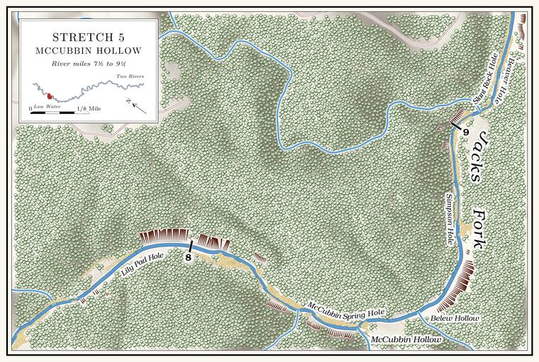
Lily Pad Hole
Pool and springs · about mile 7.9 · Plate A4
The pool known as Lily Pad Hole, about 7 feet deep at Low Water. The local name for the Highway Y bridge over the South Prong, the access beside it and the county’s low-water crossing where the prongs meet, and so for the head of the river (Chapter 8; Chapter 18). Glossary →the pool’s depth below the riffle that holds it, measured on the 2021–23 riverbed survey (Heimann, Atkinson and High 2025; Map 12)., lies under a high Bluff. A cliff along the river, usually on the outside of a bend, where the river has cut sideways into the hill. In this sense the word was first used in North America (Chapter 2; Chapter 18). Glossary → on the left, with tall pines and cedars on the grassy slope above it and lily pads along the water’s edge. A good spring comes in on the left after running about a hundred feet down a small hollow from under a rock, and two small springs flow off the hill on the right; in summer they leave little more than slick rock to mark the place. A larger spring is said to roar out of Hole. Any pool deep enough to swim or fish in, named or not, the basic unit of the river in local speech; also “hole of water” (Chapter 18). Glossary → in the bluff into a slough that reaches the river unseen through the thicket on the leftLewis 1980, PDF p. 19, the only source.. At or a short way below the hole the river passes from Texas County into Shannon CountyLewis 1980, PDF p. 19..
McCubbin Hollow and McCubbin Spring Hole
Hollow, spring and pool · right bank · mile 8.4 · Plate A4
McCubbin Hollow comes in from the south, the larger of two hollows that reach the river within a few hundred yards of each other. Its creek runs a little over two miles and drains about two square milesJacks Fork Creek Network 2026 (2.14 square miles, 3.72 kilometers).. The hollow is dark, rough and narrow, under three layersLewis 1980, PDF p. 19. of growth: tall trees, shade-tolerant underbrush, and ferns and moss on the ground.
McCubbin Spring rises about a quarter of a mile up the hollow from under several slabs of rock on its right side. It is said to average about a million gallons a day, the largest spring on the river to this point. Its branch runs out of the hollow over a Gravel bar. A bank of chert gravel and sand, usually on the inside of a bend, bare at low water (Chapter 15; Chapter 18). Glossary → into McCubbin Spring Hole. A small spring comes in at the edge of the river above the hole, and nearby is a shelterLewis 1980, PDF p. 19, the only source..
A William McCubbin is said to have lived in the hollow and run a mill in the 1850s, placed both on the Spring branch. The stream that runs from a spring to the river, such as the branch below Alley Spring (Reach H). Glossary →Lewis 1980, PDF p. 19 (text). and on the river a little below Belew Hollow. McCubbin’s Mill was still standing during the Civil WarLewis 1980, PDF p. 19 (citing a Union patrol report)., when a Union patrol came home by way of it in November 1863see Chapters 5 and 6. (Chapters 5 and 6).
Belew Hollow
Hollow, cave and shelter · right bank · mile 8.6 · Plate A4
Belew Hollow, the smaller of the pair at about three-quarters of a square mileJacks Fork Creek Network 2026 (0.73 square miles)., is short and steep, and its creek drops through it in two wet-weather waterfalls. Under the lower one is Belew Hollow Shelter, a half-horseshoe overhang about thirty-five feet wide and up to twenty feet deep, with a splash pool outside. In normal flow the hollow’s stream sinks into its bed upstream and comes out again from the back wall of the shelter. The base of the RoubidouxMSS 1982, 10–11. lies at the lip of the upper waterfall, so the two falls step from the Gasconade up into the next formation. Belew Cave, thirty-five to Forty. Forty acres, a quarter of a quarter section. A hill farm was often one or two forties (Chapter 5). Glossary → feetMSS 1982, 7. long, opens in the same stretch (Chapter 13).
Floaters on overnight tripsMOHerp. have used the mouth of the hollow as a stopping place, and in 2023 mussel surveyors found three species near itWesthoff, Laszlo and Huggins 2026, table 12.. One of the pools called Gar Hole has been placed near the mouth of Belew Hollow (Reach C; Chapter 18).
Simpson Hole
Pool and cave · about mile 8.8 · Plate A4
Simpson Hole is a good fishing hole in rocky water that suits smallmouth bass and Goggle-eye. The river’s name for the shadow bass, a sunfish, and in the state’s rules for the rock bass and its kin. The name was in use by 1840 (Chapter 16; Chapter 18; Part Six). Glossary →. A small spring enters on the right, and nearby a shelter is marked by a large sycamoreLewis 1980, PDF p. 19, the only source; lettered on his map, PDF p. 24. growing out of it. Simpson Hole Cave opens in the base of a vertical bluff in the same stretch, and anyone floating past can see its entrance, about thirty feet wide and twelve high. A caving party in 2007 found it heavily used, with the remains of a campfire, some broken formations and about two dozen pipistrelle bats, and suggested a gateJohnson 2007, 21–23. (Chapter 13). Double Cave, named for its two large entrances and mapped in 1984Johnson 2007, 20–21., lies in the same stretch between the bridge and Blue Spring.
A little below Simpson Hole an unnamed branch drains a little over a square mile from the north. It is the largest creek in the reach without a recorded nameJacks Fork Creek Network 2026 (1.12 square miles)..
Beaver Hole and Slant Rock Hole
Pools · about mile 9.2 · Plate A4
Beaver Hole, also called Beaver Den Hole, is a good fishing hole bordered by a bluff on the right. Little Bottom Hole, with a bluff on the leftLewis 1980, PDF p. 19, the only source; Beaver Hole on his map, PDF p. 24., lies somewhere above it; its place is not fixed.
Slant Rock Hole follows, and it is said to be the prettiest hole on the Jacks Fork. A high bluff stands on the right, and a large rock slants down into the water. The gravel bar on the left has long been a favorite place to campLewis 1980, PDF p. 23, the only source; the photograph caption on PDF p. 26 calls it “perhaps the most beautiful hole along the river.”.