Houston School and the Houston Rural Cemetery
Former school and cemetery · right (south) bank · about North Prong mile 6.4 · Plate A14 (cemetery symbol)
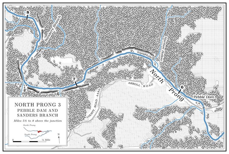
The Houston Rural Cemetery stands beside Arroll Road, County Road 4480, on the south side of the creekLewis 1980, PDF p. 9., about half a mile above the road’s crossingmeasured from the cemetery’s position (Find a Grave, Houston Rural Cemetery) and the crossing; USGS 1948 (Clear Springs).. About ninety burialsFind a Grave, Houston Rural Cemetery (94 memorials). have been recorded there. On the 1948 topographic map Houston School stood beside it, with a surveyor’s benchmark of 1,085 feetUSGS 1948 (Clear Springs). at the schoolhouse, and a map drawn in 1980 shows both the school and the cemetery between the old mill and Harmon HollowLewis 1980, PDF p. 10 (map)..
The school’s name has two explanations. In one, Houston School, District No. 15, was named for T. J. Houston, “who was instrumental in building the school.” In the other it was named for Houston Scalt, from ArkansasLewis 1980, PDF p. 9.. Neither ties it to Houston, the county seat, about seventeen milesmeasured (about 17.3 miles, straight line from Houston to the cemetery). to the northwest. District No. 15 is placed in Pierce TownshipO’Brien 1939, 63., and whether the school by the cemetery lay in Pierce or in Date Township has not been settled from a district map. The cemetery probably took its name from the school.
Harmon Hollow
Hollow · left bank · North Prong mile 6.25 · Plate A14
Harmon Hollow is a short hollow from the north, draining about two-thirds of a square mileUSGS GNIS; Jacks Fork Creek Network 2026., that reaches the Prong. A branch or arm of a creek, set down in 1860 as Southern usage. The North and South Prongs join to form the Jacks Fork (Chapter 18). Glossary → about half a mile above the Arroll Road crossingmeasured (mile 6.25 against 5.77).. Houston School stood near itLewis 1980, PDF p. 9., and the hollow carries the name of an early family on the prongLewis 1980, PDF p. 9. (see Harmon Branch above). The newcomer of 1979Jacks Fork Oral History, record SV-05. who fished by Route 137 knows the place as “Harlow crossing.”
Pebble Dam and the Arroll Road crossing
Dam, road crossing and swimming hole · North Prong mile 5.8 · Plates A1 and A14
Pebble Dam is at the Arroll Road crossing of the North Prong, about five and three-quarter miles above the junction, about half a mile below the mouth of Harmon Hollow and a little more than half a mile below the Houston Rural Cemeterymeasured on the traced channel (mile 5.77, against 6.25 and 6.44) at the crossing that SV-09 and SV-20 marked, their marks within about 70 yards of each other (Jacks Fork Oral History, records SV-09 and SV-20); the crossing is the ford of USGS 1987 (Clear Springs).. A map of 1980 marks a Ford. A place where a road crosses through the water. Many of the river’s fords took the names of the families who lived beside them (Chapter 8). Glossary → a little below Harmon Hollow, about here, with a spring on the south sideLewis 1980, PDF p. 10 (map). a short way below it, where a small Branch. A small creek. The sense is American, on record from 1674 (Chapter 18). Glossary → comes in from the southwest. People from Mountain View and Arroll know the placeJacks Fork Oral History, records SV-05, SV-09, SV-20 (SV-09 and SV-20 marked the crossing on maps). as Pebble Dam. A Mountain View resident who grew up at Arroll calls it Pebble Rock Dam: “There is a dam and a bridgeJacks Fork Oral History, record SV-20., and a swimming Hole. Any pool deep enough to swim or fish in, named or not, the basic unit of the river in local speech; also “hole of water” (Chapter 18). Glossary → with a large rock to jump off of. That’s why it’s called Pebble ‘Rock’ Dam.” The resident’s summers at the damsee Chapter 19. are told in Chapter 19. Asked where the North Prong has a falls or ledge, the resident answered that “the drop off or ledge in this fork is actually at the Dam at Pebble Rock Dam.” The newcomer of 1979 described it only as “Arrollo road,” marking a spot near Arroll on a map.
What the dam was built for is uncertain. By the account of an Arroll resident who grew up there, it went in during the 1920s or 1930s “to power the gist ranch lodge.” No record of a lodge, a power plant or the dam’s construction has been found. The federal wetland maps show a Pool. A deep, slow stretch of river between riffles (Chapter 16). Glossary → of 2.79 acres impounded in the channel of the North Prong, the largest dammed or diked water beside any sizable stream in the whole Jacks Fork watershed and the only such pool listed on the prong, so it is probably the pool behind Pebble DamMDC 2001, PDF 96, 104 (table Hc01, from National Wetlands Inventory data: eight diked or impounded waters within 100 feet of third-order and larger streams, one of them, of 2.79 acres, in the channel of the North Prong). The match to Pebble Dam is an inference..
The newcomer of 1979 remembered friends who were camping at Pebble Dam and were nearly swept away by a Flash flood. A sudden, fast rise of water after heavy rain, fed by quick runoff from steep slopes (Chapter 14). Glossary →, losing both of their vehiclesJacks Fork Oral History, record SV-05; see Chapters 8 and 14. (Chapters 8 and 14). The Mussel. A freshwater clam that lives half-buried in the riverbed and filters its food from the water. Mussels on the Jacks Fork fell sharply between the surveys of 1982 and 2017–19 (Chapter 16). Glossary → search of 2017–19 that found nothing about five and a half miles above the junctionMcMurray and Faiman 2023, 15 (table 3, river kilometer 9.0). was close to the crossing.