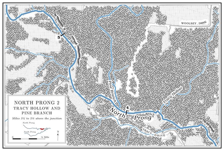
Pine Branch and East Fork Pine Branch
Branch · left bank · North Prong mile 4.1 · Plate A14
Pine Branch is the Prong. A branch or arm of a creek, set down in 1860 as Southern usage. The North and South Prongs join to form the Jacks Fork (Chapter 18). Glossary →’s other large tributary, draining between eight and nine square miles from the north. It runs four or five miles and falls about 140 feet to the mile near its head. None of it is mapped as permanent stream, though its lower four miles are classed as water that keeps permanent Pool. A deep, slow stretch of river between riffles (Chapter 16). Glossary →. East Fork Pine Branch, about three and a half miles long and draining more than three square miles, joins it a little over a mileMDC 2001, PDF 28–32, 90–91; Jacks Fork Creek Network 2026; USGS GNIS. above its mouth. In the late 1990s less than one percentMDC 2001, PDF 107 (table Hc04: 0.01 mile, 0.2 percent). of Pine Branch ran through land more than a quarter cleared, the best record of any stream its size in the watershed. The prong’s flatter last four miles begin about here.
A cemetery stands on the ridge above Pine Branch, where Criders from Belle and Farrars from Texas and Shannon counties are buried. A skirmish between Northern and Southern forces is said to have been fought near it, with casualties on both sides and some Germans from BelleLewis 1980, PDF p. 11, the only source; he gives no date. among the fighters. The war on the Jacks Fork is told in Chapter 6.
Tracy Hollow and Rocky Ford
Hollow, former ford, church and cemeteries · left bank · North Prong mile 3.7 · Plate A14
Tracy Hollow is a short hollow of about a square mile from the north, about four-tenths of a mile below Pine BranchUSGS GNIS; Jacks Fork Creek Network 2026..
Rocky Ford crossed the prong below Pine Branch, near the mouth of Tracy Hollow. It had two cemeteries, an old one that had partly washed away by 1980 and a newer one started after it. Some of the graves are said to be of Delaware Indians, and Woolseys and Thorps are buried there too. The Delaware lived on the “Currents” in the early 1820ssee Chapter 4., and how far up the Jacks Fork they reached is taken up in Chapter 4. The Rocky Ford church stood below the Ford. A place where a road crosses through the water. Many of the river’s fords took the names of the families who lived beside them (Chapter 8). Glossary →, with Joseph Nagle as its pastor. Ben Meador ran a small mill below the ford and may have come into the country with the DelawareLewis 1980, PDF p. 11, the only source (the Delaware graves and Meador’s coming are his account and supposition)..