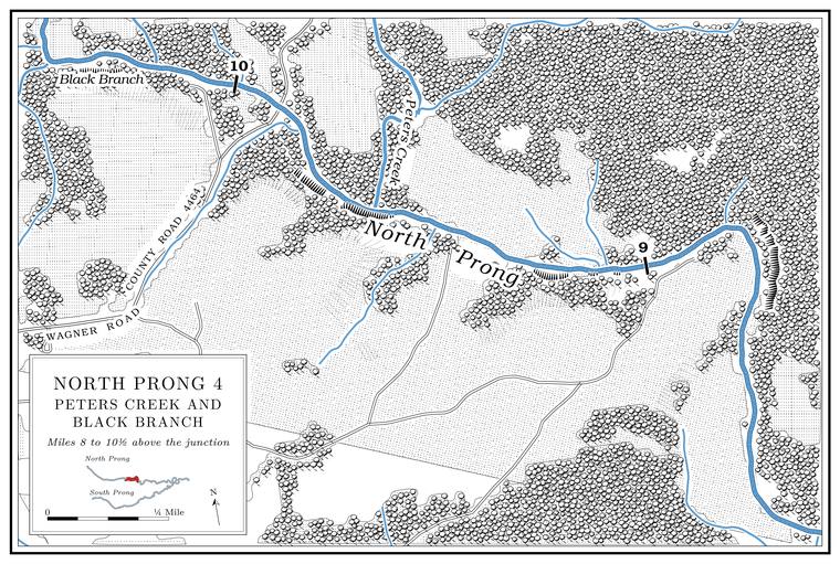
Black Branch
Branch · right bank · about North Prong mile 10.4
Black Branch is a Branch. A small creek. The sense is American, on record from 1674 (Chapter 18). Glossary → of nearly two miles from the southwest, draining a little less than a square mile. The Blacks were an early family here, settled before the Civil WarLewis 1980, PDF p. 9, the only source.. A little below it, at about mile 10.2, a creek of about two and a half square milesUSGS GNIS; Jacks Fork Creek Network 2026 (1.83 miles, straight line from source to mouth). enters from the north on the left bank. It has no recorded name.
Peters Creek
Creek · left bank · North Prong mile 9.6 · Plate A14
Peters Creek is the North Prong’s largest tributary. It drains nearly 12 square milesJacks Fork Creek Network 2026. from the north and runs between five and a half and seven miles, depending on the measurement. Only about two and a third of its miles are mapped as permanent stream, and its lower three and a half milesJacks Fork Creek Network 2026; MDC 2001, PDF 28–30, 90–91. are classed as water that may stop flowing in dry weather but keeps permanent Pool. A deep, slow stretch of river between riffles (Chapter 16). Glossary →. It heads in the Gist Ranch country and is the only stream named on the conservation area’s mapMDC, Gist Ranch Conservation Area (area map).. Several smaller branches feed it, none of them named.
The creek takes its name from a cattle ranch. The Western Land and Cattle Company, founded in London in 1881, bought 28,000 acres in Texas County in 1883, including the land along the North Prong. Charles E. Peter came from Scotland in 1885 to manage it, the property became known as Peter’s Ranch, and the creek was named for him. About 14,000 acres of the ranch lay along the North Prong, and in 1980 the tract was still in one piece, grown to about 18,000 acresLewis 1980, PDF p. 9, the only source (the scan reads “14,00”; read here as 14,000).. Whether the conservation area is part of the same block of land has not been traced through the deeds (The Open Ledger).
The mouth of Peters Creek lies on the federal map sheet named for Eunice, a village to the north, named for the wife of W. B. Cooper, who opened its post office in 1891O’Brien 1939, 45..
Sanders Branch, Spargo Branch and the old mill
Branches, mill site and road crossing · Sanders Branch left bank, Spargo Branch right · about North Prong miles 8.2 to 7.8 · Plate A14
Two creeks of about three square miles each reach the Prong. A branch or arm of a creek, set down in 1860 as Southern usage. The North and South Prongs join to form the Jacks Fork (Chapter 18). Glossary → about a third of a mile apart here. The upper one, Spargo Branch, comes from the west on the right bank at about mile 8.2. The lower one, Sanders Branch, comes from the northeast on the left bank at mile 7.8, runs about four miles and drains about three and a half square milesJacks Fork Creek Network 2026 (Sanders Branch 4.1 miles, straight line from source to mouth).. Every map that names them, from the 1948 topographic sheet on, places them soUSGS 1948 (Clear Springs); USGS GNIS (sources to the west and to the northeast); Lewis 1980, PDF p. 10 (map).. Neither name has an explanation on record.
A gristmill stood on the prong a little above the mouth of Sanders Branch and was running before 1837. At one time it was called Mahan’s Mill. Shortly before 1980 a shift in the channel uncovered its main beams, walnut timbers Forty. Forty acres, a quarter of a quarter section. A hill farm was often one or two forties (Chapter 5). Glossary → feet long joined by four cross membersLewis 1980, PDF p. 9, the only source.. At least three more mills stood above the Prongs, and two of them may have shared one site below Sanders Branch. Reuben Harlow ran one in 1860 and the Campbell Brothers another in 1880; which prong each stood onLewis 1980, PDF p. 9 (Lewis’s supposition that two shared a site; he does not give the prong); see Chapter 5. is not known (Chapter 5). Harlow is remembered in Texas County as one of its earliest settlersO’Brien 1939, 57; see Chapter 5. (Chapter 5), and his family’s name is on Harlow Ford below the Prongs (Reach C).
The Ford. A place where a road crosses through the water. Many of the river’s fords took the names of the families who lived beside them (Chapter 8). Glossary → beside the mill carried the road from Jefferson City to Little Rock, laid out in 1837 with federal money to connect the two capitals. Part of it was cleared, but it was never finished. Trails to the West are said to have crossedLewis 1980, PDF pp. 9, 10 (map, “Jefferson City–Little Rock Road Crossing”); the trails are Lewis’s explanation. the upper Jacks Fork because the country to the south was too rough to cross easily. The roads that came later are described in Chapter 8.