Old River Bay and the turn north
Pools and campground · right bank (campground) · about miles 39.2 to 39.7 · Plate A13
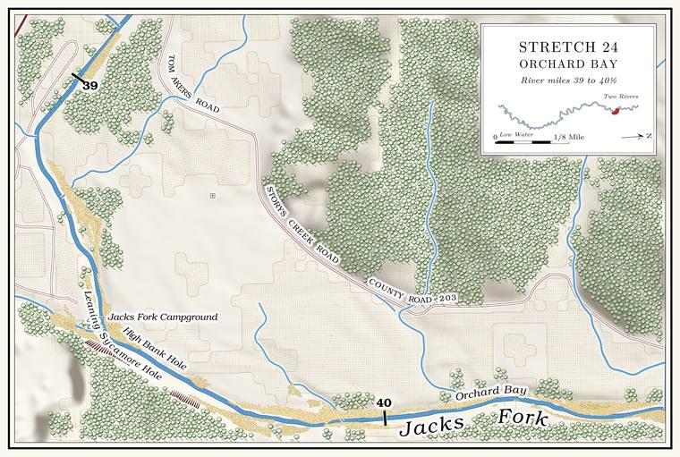
Below the town the river runs east, and at about mile 39.5 it turns north. At the turn a map of 1980 letters Old River BayLewis 1980, PDF p. 66 (map), the only source.. The Jacks Fork Campground lies on the rightPlate A13. here, the old Pickin’ and Grinnin’, a favorite riverside hangout of Eminence young people in the late 1990sGibson 2000, 75; see Chapter 19. (Chapter 19). Beside the campground a small creek of a little over half a square mile comes in on the right at about mile 39.4Jacks Fork Creek Network 2026 (an unnamed right-bank branch of 1.46 square kilometers at about mile 39.44); Plate A13 draws it entering at the campground.. Leaning Sycamore Hole comes next, about 7 feet deep at Low Water. The local name for the Highway Y bridge over the South Prong, the access beside it and the county’s low-water crossing where the prongs meet, and so for the head of the river (Chapter 8; Chapter 18). Glossary →, and High Bank Hole below it, about 5the pool’s depth below the riffle that holds it, roughly its low-water depth, measured on the 2021–23 riverbed survey (Heimann, Atkinson and High 2025; Map 12; pools at about miles 39.54 and 39.59).. The leaning sycamore that named the upper Hole. Any pool deep enough to swim or fish in, named or not, the basic unit of the river in local speech; also “hole of water” (Chapter 18). Glossary → was a stump by 1980.
Orchard Bay, the Coppermine hollows and Cut Bank Hole
Bay, hollows and pool · about miles 39.9 to 40.6 · Plate A13
The river runs north for about a mile and a quarterthe river centerline (about miles 39.5 to 40.8).. Orchard Bay lies on the rightLewis 1980, PDF p. 66 (map); Plate A13. at about mile 40.0, where a short hollow of about three-quarters of a square mileJacks Fork Creek Network 2026 (0.73 square miles, mouth at 40.01, right, unnamed). comes in from the southeast. Two hollows here carry the name Coppermine. By one account the one on the east bank runs toward Coppermine Flats and the old Slater diggings and the one on the west bank toward the Casey Mine. The federal maps give the name to the western one, a short valley of less than half a square mile that comes in on the left at about mile 40.4USGS GNIS (Coppermine Hollow, valley, 716304); Jacks Fork Creek Network 2026 (0.45 square miles, mouth at 40.43, left).. By the same account it was also called Council Hollow, said to be where the Shawnee held their councils (Chapter 4), and in later years a man named Gates ran a sawmill in it. The coppersee Chapter 5. that named both hollows is told in Chapter 5.
A map of 1980 letters FallsLewis 1980, PDF p. 66 (map), the only source. a little below Orchard Bay, and below that lies Cut Bank Hole, a long Pool. A deep, slow stretch of river between riffles (Chapter 16). Glossary → about 4 feet deep at low waterthe pool’s depth below the riffle that holds it, roughly its low-water depth, measured on the 2021–23 riverbed survey (Heimann, Atkinson and High 2025; Map 12; pool at about mile 40.56)., with a high yellow clay bank on the right. The crossing just above Lick Log Hollow, with its big Gravel bar. A bank of chert gravel and sand, usually on the inside of a bend, bare at low water (Chapter 15; Chapter 18). Glossary →, is a trail-ride crossing where boaters and swimmers stop to picnic. In the bacteria studies of 2000 to 2004 it lay outside the park boundary, and as many as 500 horses an hourDavis and Barr 2006; see Chapter 17. crossed there on ride days (Chapter 17).