Lick Log Hollow and the Hole-in-the-Wall
Hollow, bluff and pool · left bank · about miles 40.9 to 41.1 · Plate A13
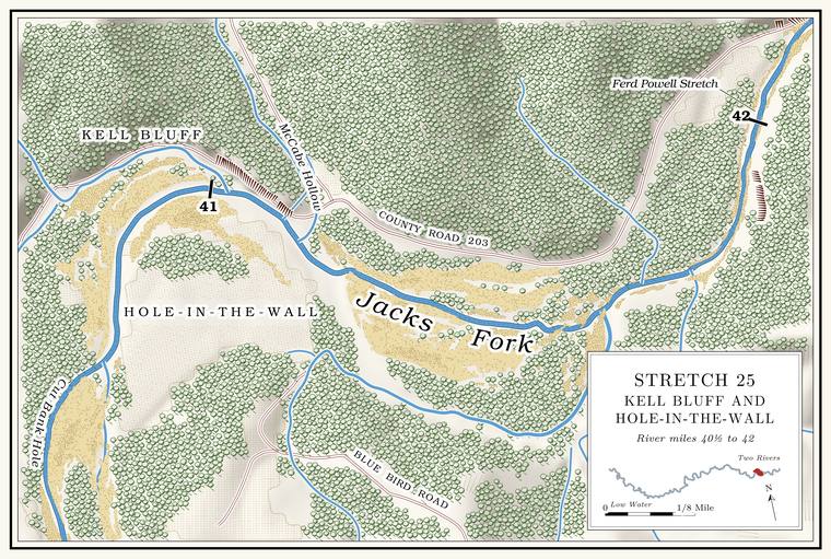
Lick Log Hollow comes in on the left at about mile 40.9, at the top of the bend where the river turns from north to southeastthe river centerline (north at 40.8, southeast at 41.0).. It drains about three-quarters of a square mileJacks Fork Creek Network 2026 (0.73 square miles, mouth at 40.87, left); USGS GNIS (Lick Log Hollow, valley). and is said to be named for an early deer Lick. A spot where animals come to lick salt or salty earth, an American word from 1751 (Chapter 18). Glossary →. By one account water runs in it, and at one point it flows through a set of Shut-in. A narrow, rocky gorge where a stream cuts through hard rock (Chapter 2). Glossary → in Granite. A coarse-grained rock made of magma that cooled slowly underground. Granite near Big Spring has been dated at about 1.46 billion years (Chapter 1). Glossary → rock, and Slater’s miners took some copper out of its upper part (Chapter 5). The Hole-in-the-Wall is the Bluff. A cliff along the river, usually on the outside of a bend, where the river has cut sideways into the hill. In this sense the word was first used in North America (Chapter 2; Chapter 18). Glossary → and Pool. A deep, slow stretch of river between riffles (Chapter 16). Glossary → at its mouth, on the outside of the bendLewis 1980, PDF p. 66 (map, Hole-in-the-Wall lettered from the mouth of Lick Log Hollow, at the top of the bend, along the left bank of the run below it to the mouth of Kell Hollow).. The bluff rises about 90 feet just below the mouthmeasured on the flood-mapping terrain (Heimann, Atkinson and High 2025; Map 13), the face on the left at about miles 41.00 to 41.09, tallest at its upstream end. It is the only face of 50 feet or more on either bank between Cut Bank Hole and the low bluff at the mouth of Bald Knob Hollow, and it lies along the run the 1980 map letters Hole-in-the-Wall., and an old photographLewis 1980, PDF p. 67 (“Hole-In-The-Wall Bluff and Hole”). shows it standing over still water. The old Barnesville Road ran down the river past it. An Eminence resident who has done park work placed the Hole-in-the-Wall at the mouth of the hollowJacks Fork Oral History, record SV-12 (marked on a map beside the mouth of Lick Log Hollow, at about mile 40.9)..
McCabe Hollow and Kell Bluff
Hollow and bluff · left bank · about miles 41.1 to 41.3 · Plate A13
A quarter mile below, McCabe Hollow comes in from the north, a valley of about two-thirds of a square mileJacks Fork Creek Network 2026 (0.68 square miles, mouth at 41.12, left); USGS GNIS (McCabe Hollow, valley, 722029).. A map of 1980 calls the hollow at this place Kell HollowLewis 1980, PDF p. 66 (map). and gives the name Jim McCabe Hollow to the hollow at Powell SpringLewis 1980, PDF p. 74 (“Powell Spring is at the mouth of Jim McCabe Hollow”); map PDF p. 77., a mile and a half downstream. Kell Bluff stands on the left a little below the Hole-in-the-WallLewis 1980, PDF pp. 66 (map, Kell Bluff lettered on the left below the mouth of Kell Hollow, where the river turns from south to east, with the dotted Barnesville Road drawn between the lettering and the river), 75 (named for former residents); the river centerline (Lick Log Hollow at 40.87, McCabe Hollow at 41.12, south-southeast at 41.15–41.2 and east-southeast from 41.25). The place is read from a sketch map and is approximate., with the old Barnesville Road between it and the riverthe 1980 map. Kell Bluff is probably low or set back from the water: on the flood-mapping terrain no face of 50 feet or more rises within about 150 feet of the water on the left from 41.1 to 41.4 (Heimann, Atkinson and High 2025; Map 13). Another reading takes Kell Bluff for the lower end of the Hole-in-the-Wall face, which reaches nearly to the mouth of McCabe (Kell) Hollow; the 1980 map and photograph caption (“Hole-In-The-Wall Bluff”) keep the two names apart., probably just below the mouth of the hollow at about mile 41.2, where the river swings from south-southeast to east-southeast.
Turkey Pen Hollow, Bald Knob Hollow and the Ferd Powell Stretch
Shoal, hollows, stretch and pool · about miles 41.6 to 42.4 · Plate A13
Below Kell Bluff the river runs southeast for half a mile and turns northeastthe river centerline (about miles 41.0 to 41.6).. A rough Shoal. A fast, shallow, rocky stretch between pools; a riffle. Suckers crowd onto the shoals in spring, and the old saying is that “the dogwoods bloom when the suckers are shoaling” (Chapter 18; Chapter 19). Glossary →, with rounded Dolomite. Calcium magnesium carbonate rock, a close relative of limestone, formed from lime mud on the floor of a warm, shallow sea. Nearly every bluff on the Jacks Fork is dolomite (Chapter 1). Glossary → bedrock jutting up through the water, marks the stretch above Turkey Pen Hollow, which comes in on the right at about mile 41.7Lewis 1980, PDF p. 77 (map, Turkey Pen Hollow from the south at the shoal). with a good spring seeping out of its mouth. The hollow is said to take its name from a turkey pen, a box trap of rails baited with corn, with a trench dug under one side. The turkeys walked in through the trench and tripped a trigger tied to a door.
Bald Knob Hollow comes in on the left at about mile 42.2, a short hollow of about half a square mileJacks Fork Creek Network 2026 (0.54 square miles, mouth at 42.20, left); USGS GNIS (Bald Knob Hollow). with a low bluff at its mouth. A map of 1980 marks a spring thereLewis 1980, PDF p. 77 (map, “Spring” at the mouth of Bald Knob Hollow)., and whiskey is said to have been made in the hollow. The Ferd Powell Stretch runs along the left bank here, with the old river road between it and the bluff. Below it lies Andy P. Bales Hole, deep by one account of 1980, with a big rock at its lower end. Andy P. Bales was probably Andrew Powell Bales, of the Eminence family of David L. Bales and the Bales Boating Companyan inference from the name. Shannon County cemetery readings (Old Eminence Cemetery) list an Andrew Powell Bales, and David L. Bales and Mae Estelle Powell, as parents of children buried there; Lewis 1980, PDF p. 68 (David L. Bales, and his son Walter’s Bales Boating Company); see Chapter 9. (Chapter 9).