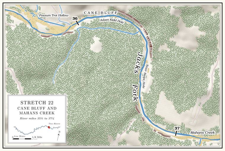
Pistol Barrel Hollow, Possum Trot Hollow and Adam Kidd Hole
Hollows and pool · left bank (hollows) · about miles 35.7 to 36.0 · Plate A11
Pistol Barrel Hollow comes down from the north and runs along the left side of the valley floor to reach the river with Possum Trot HollowJacks Fork Creek Network 2026 (1.19 square miles, mouth at 35.70, left, unnamed in the network); USGS GNIS (Possum Trot Hollow, valley, 724782, falls beside it at 35.72). at about mile 35.7Lewis 1980, PDF p. 57 (map, Pistol Barrel Hollow lettered along the north bank from Boiler Hole to the mouth of Possum Trot) and p. 54 (“The Adam Kidd Hole is just below Pistol Barrel and Possum Trot Hollows”); Plate A11 (a left-bank channel from about 34.6 parallel to the river, joining Possum Trot about 35.7); the place register’s elevation-data check of the federal valley point, which drains to the system entering at 35.71. The creek network instead gives Pistol Barrel Hollow its own mouth at 35.27; the conflict is unresolved.. There are springs in Pistol Barrel and below it. Adam Kidd Hole lies a little below the two hollows. Adam Kidd lived at the mouth of Possum Trot, and the Hole. Any pool deep enough to swim or fish in, named or not, the basic unit of the river in local speech; also “hole of water” (Chapter 18). Glossary → is also called the Barnes Bluff Hole. The Barnes were an early family on the south side of the river, and Barnes Bluff stands on that side.
Cane Bluff and the Barnes fords
Bluff, fords and spring · left bank (bluff) · about miles 36.1 to 36.5 · Plate A11
Cane Bluff stands on the left at the outside of the bend where the river swings from northeast to southPlate A11; Lewis 1980, PDF p. 57 (map); the river centerline., and rises about 120 feetmeasured on the flood-mapping terrain (Heimann, Atkinson and High 2025; Map 13), the face on the left at about miles 36.4 to 36.5, at the outside of the bend.. The Upper Barnes Ford crossed between Barnes Bluff and Cane Bluff, and the Lower Barnes Ford crossed below Cane Bluff. Barnes Spring comes in below the Cane Bluff Hole. By one account it used to flow into a bay that was an excellent fishing spotLewis 1980, PDF p. 54, the only source..
The logging railroad ran along the foot of Cane Bluff, and an old photographLewis 1980, PDF pp. 57 (map, railroad along the north bank), 60 (photograph, “The railroad at Cane Bluff on the Jack’s Fork”). shows the track there. A photograph of the river at Cane Bluff taken about 1910Jacobson and Primm 1994, 68, 72 (fig. 25, “Replicate photographs of the Jacks Fork at Cane Bluff near Eminence, Missouri, about 1910 and 1992”); see Chapter 15., set beside one taken from the same place in 1992, shows less gravel and steadier, more wooded banks in the later picture (Chapter 15).
Cane Bluff is probably the Bluff. A cliff along the river, usually on the outside of a bend, where the river has cut sideways into the hill. In this sense the word was first used in North America (Chapter 2; Chapter 18). Glossary → also called King’s Bluffan inference. A place label on Google Maps puts King’s Bluff on the left bank at the outside of a bend between Possum Trot Hollow and Mahans Creek (Google Maps 2026). The railroad ran along the north bank only above its crossing near the mouth of Mahans Creek, and Cane Bluff is the bluff along whose foot it ran (Lewis 1980, PDF pp. 57, map, and 60, photograph).. A Mountain View resident who grew up near Arroll had heard the name without placing itJacks Fork Oral History, records SV-20 (“Heard of it, not sure where”) and SV-12 (marked on a map at about mile 37.4, 27 meters left of the channel); SV-17 did not know it. No bluff face of 50 feet or more stands on the left there; the nearest face, about 100 feet high, is on the right at about miles 37.3 to 37.4 (Heimann, Atkinson and High 2025; Map 13)., and an Eminence resident who has done park work placed King’s Bluff about a mile lower, on the left a little below the mouth of Mahans Creek.
Flat Hole, Stair Steps Hole and Jones Mountain
Pools and hill · about miles 36.5 to 36.9 · Plate A11
Below the Lower Barnes Ford come the Flat Hole, small, flat and rock-bottomed, and the Stair Steps Hole, a bluff hole also called the Rock Hole, about 5 feet deep at Low Water. The local name for the Highway Y bridge over the South Prong, the access beside it and the county’s low-water crossing where the prongs meet, and so for the head of the river (Chapter 8; Chapter 18). Glossary →the pool’s depth below the riffle that holds it, roughly its low-water depth, measured on the 2021–23 riverbed survey (Heimann, Atkinson and High 2025; Map 12; pool at about mile 36.83).. This Flat Hole is a different Pool. A deep, slow stretch of river between riffles (Chapter 16). Glossary → from the Flat Hole above Bay Creek, where ties are said to have gone into the river down a Chute. A narrow, fast slot of water through a shoal or past an obstacle. A smooth V of water pointing downstream marks the deepest path through it (Chapter 20). Glossary → (Reach F). Jones Mountain, also called Bald Hill, rises on the south side, where Bud Jones homesteadedLewis 1980, PDF p. 54; map PDF p. 57..
Mink Trap, Counts Ford and the railroad crossing
Fords, spring and crossing site · about miles 36.9 to 37.1 · Plate A11
Mink Trap, a little above the old railroad crossing, had three good places to set steel traps. The Counts Spring, also called the Lee Ellerman Spring, runs in near it. On May 20, 1885, John W. Counts homesteaded 160 acres at the mouth of Mahans Creek. He married Rebecca Chilton, a daughter of Joshua and Elizabeth Chilton, and by one account Counts Ford got its name when he nearly drowned there riding an untamed horseLewis 1980, PDF p. 54, the only source; map PDF p. 57 (“Mink Trap,” “Counts Ford,” “Piling”)..
The logging railroad came north down the Mahans valley in 1907, crossed the Jacks Fork on a trestleLewis 1980, PDF p. 56 (“Tressel bridges crossed the Jacks Fork at the mouth of Mahans Creek”). a little above the mouth of the creek, and ran west along the north bank to the mouth of Horse Hollow and up the hollow to the camp at AngelineStevens 1991, 90; MDC 2003 (“Site of old R.R. river crossing just above mouth of creek”); see Chapters 7 and 8. (Chapter 7). A party of Carthage fishermen floating the river on May 24, 1907, saw the first engineStevens 1991, 151–52; see Chapter 7. cross. The rails came up in 1929see Chapter 7., and in 1980 the pilings could still be seen in the river a little belowLewis 1980, PDF p. 54. Mink Trap.
Mahans Creek
Creek · right bank · mile 37.1 · Plates A11 and A16
Mahans Creek is the largest creek on the Jacks Fork. It drains about fifty-four square milesJacks Fork Creek Network 2026 (53.94 square miles, mouth at 37.12, right); MDC 2001, PDF 21 (fig. Ge06, Mahan’s Creek drainage unit, 54.0 square miles)., more than two and a half timesJacks Fork Creek Network 2026 (the next largest creek entering the river is Jam Up Creek, 20.73 square miles). as much as any other, and runs about thirteen milesMDC 2001, PDF 28–30 (table Ge03, 13.2 miles total); the creek network traces about 15.4 miles (24.83 km) from the farthest head. north to the river. It is the only creek below the Prong. A branch or arm of a creek, set down in 1860 as Southern usage. The North and South Prongs join to form the Jacks Fork (Chapter 18). Glossary → built from four generations of smaller streams joining, a fifth-orderMDC 2001, PDF 28–32 (tables Ge03–Ge05); its other fifth-order streams are the prongs above the junction. stream in the hydrologists’ count. It falls about twenty-nine feet to the mileMDC 2001, PDF 31–32 (average gradient 28.6 feet per mile). and runs all year in about its lower nine milesMDC 2001, PDF 28–30 (table Ge03, 8.7 permanent miles).. Thirty-five kinds of fish have been counted in the creek’s country, among them smallmouth bass, shadow bass, black redhorse, the Arkansas saddled darter and the Ozark shiner, with the Ozark pigtoe and the Ozark brokenray among its Mussel. A freshwater clam that lives half-buried in the riverbed and filters its food from the water. Mussels on the Jacks Fork fell sharply between the surveys of 1982 and 2017–19 (Chapter 16). Glossary → and yellow lady’s slipper, ginseng and river caneMDC, Mahan’s Creek priority area (a conservation priority area of 67,653 acres around the creek, 36 percent of it in public ownership). among its plants. By one account Mrs. Jeston BolinLewis 1980, PDF p. 54, the only source. drowned at its mouth; she is buried in the Culpepper Cemetery.
By one account the Mahans were one of the firstLewis 1980, PDF p. 54, the only source (“It has been written that…”). The source also cites the census of 1830 for Wayne County, with four Mahan households. The name: see Chapter 18 (O’Brien 1939, 80, has the creek named for a family at its head). families in what became Shannon County, if not the first. A William Mahan is said to have come into the country in 1779 with a hunting party of Shawnee and Delaware, and his son to have settled on the creek in 1808. By the same account the creek is named for a later William Mahan, son of James and Jane Mahan, whose family came from Pennsylvania by way of Ohio and Indiana in 1826 and who settled by the spring below Bohannon, or Pummill, Hollow (Chapter 18). By one account he applied for a post office on April 13, 1860Lewis 1980, PDF p. 54, the only source for the year; Chapter 5 gives the Mahon’s Creek office “by 1867” (O’Brien 1939, 80)., and it went on the books as Mahon’s Creek (Chapter 5). About 1855Lewis 1980, PDF p. 54; mouth of Bohannon or Pummill Hollow: Lewis 1980, PDF p. 61. The source gives the mill’s output for 1860 and 1879, apparently from the federal censuses of manufactures., by the same account, he built a small mill near the mouth of Bohannon Hollow, with stone burrs fastened to a wooden shaft and an Overshot wheel. An upright water wheel fed at the top, turned by the weight of water in its buckets (Chapter 5). Glossary →. A man named Lloyd rebuilt it in the late 1870s. The war on the creek, the skirmish of October 1863 with its story of the cavalrymen’s trophies and the Union patrol of that Novembersee Chapter 6., is told in Chapter 6.
Up Mahans Creek to Delaware
Creek valley · Plate A16
Going up the creek, the first good springLewis 1980, PDF p. 61, the only source; map PDF p. 57. is the Bill Smith or Jim Burrus Spring, and the Willow Hole comes next. By one account the creek used to run a lot of water, enough for boats in the Gig, gigging. A gig is a spear of three or four barbed iron tines on a pole as much as fourteen feet long. Gigging is spearing fish with it from a boat in clear, shallow water, chiefly suckers, by night under lights or by day (Chapter 19). Glossary → months, and in later years Willie Key drowned trying to cross it in his four-wheel-drive pickup. Broadfoot Hollow and Big BranchPlate A16; Jacks Fork Creek Network 2026. come in from the sides of the lower valley.
DelawareLewis 1980, PDF p. 61. lies at the junction of Pine Hollow and Mahans Creek. Pine Hollow comes in from the southwest with Larkin, Jam Up, Dry Camp and Spring Camp hollows, and about two miles of it are officially a Losing stream. A creek that gives up its flow to the bedrock and runs dry for long stretches. Jam Up Creek, Pine Hollow and Johnny Hollow are the officially listed losing streams of the watershed (Chapter 12). Glossary →MDC 2001, PDF 26 (table Ge01); see Chapter 12. (Chapter 12). This Jam Up Hollow lies far from Jam Up Cave and Jam Up Creek upriver, and how the two came to share the name is unsettledsee Chapter 18. (Chapter 18). Above Delaware, Mahans Creek comes from the south past Open Hollow, with Pin Oak Hollow in it, and Turnback and RailroadPlate A16; Lewis 1980, PDF p. 65 (“Mahan’s Creek and Open Hollow run to the south. Pine Hollow runs to the southwest”); MDC 2001, PDF 28–30 (table Ge03: Dry Camp Hollow into Pine Hollow; Pine, Open and Railroad hollows into Mahan’s Creek; Pin Oak Hollow into Open Hollow). hollows. The Delaware schoolLewis 1980, PDF p. 61, the only source. washed off its foundation in a flood in 1895, by one account, and the schoolhouse became a church. By one account a post office named Delaware ran from 1871 to 1873Lewis 1980, PDF p. 56 (May 29, 1871, to June 24, 1873; Henry B. Catlett, postmaster), the only source., and another ran from 1923 or 1924 to 1941see Chapter 5. (Chapter 5). The Township. A survey square of six miles on a side, holding thirty-six sections; also a division of a county, such as Jack’s Fork Township (Chapter 5). Glossary → and the village carry the name of the Delaware people who lived on the river in the early 1820sO’Brien 1939, 36 (Delaware Township, “Named for the Delaware Indians”); see Chapter 4. (Chapter 4).
The valley was logged from both ends. In the 1890s Cordz-Fisher ran a Tram, tramway. A light logging railroad laid up a hollow, such as Cordz-Fisher’s line down Pine Hollow (Chapter 7). Glossary → down Pine Hollow toward Mahans Creek, and Dry Camp was one of its campsLewis 1980, PDF p. 56 (“in about 1894”); see Chapter 7, which has the tram begun in 1893 and lists Dry Camp among its camps. (Chapter 7). In 1907 the lumber company’s line, later the Salem, Winona and Southern, came down Mahans Creek, and from 1909 it had a loading chute, stock pens and a flag station at DelawareStevens 1991, 90; Rader 2017, ch. 8; see Chapter 7. (Chapter 7). Pertz, a stop on the line along the upper creek, had a post office from 1900Lewis 1980, PDF p. 65 (Edward Von Pertz, postmaster, March 26, 1900)., by one account.
West Eminence
Mill town, site · up Mahans Creek near the mouth · Plate A11
The lumber company’s mill town of West Eminence stood a short way up Mahans Creek, about a mile west of Eminence (Chapter 7). In December 1906 Shade Orchard sold his farm to the company for the town, and the mill was built in 1909 and 1910. The Martin Hub Mill, which made wagon hubs of clear white oak, stood by the bluff between the Christian Church and the elementary school and is said to have burned about 1926Lewis 1980, PDF p. 61, the only source; map PDF p. 57.. By one account the county poor farm moved to West Eminence in 1927 and closed in 1948; the county’s purchase of company landsee Chapter 7, which has it after the town was offered for sale in November 1928. is told in Chapter 7. Someone who grew up in Eminence had heard of a Civilian Conservation Corps camp at West Eminence, where Mahans Creek runs into the Jacks ForkJacks Fork Oral History, record SV-15 (“The CCC camp that I have heard anything about was in West Eminence”), the only source; the sources for the Alley camp give no camp at West Eminence.; the camp set up on the Jacks Fork in 1933 stood at Alleysee Reach H. (Reach H). In 1980 the ruins of the big mill could still be seen. By one account James MahanLewis 1980, PDF p. 61; see Chapter 6. was shot in November 1863 where West Eminence stands now (Chapter 6).