Rough Hollow
Hollow · left bank · about mile 16.3 · Plate A5
Rough Hollow comes in on the left a little above the Rymers landing, on the opposite bank, draining a little over a square mileJacks Fork Creek Network 2026 (1.1 square miles).. In April 2007 cavers paddled up it as far as they could before the brush closed inJohnson 2007, 31.. That angler calls it “Ebb n flow.”
Rymers
Landing and backcountry campground · right bank · mile 16.5 · Plate A5
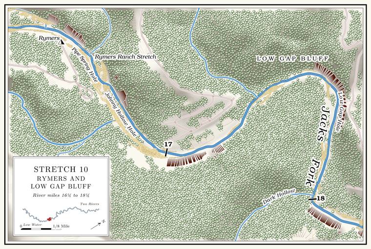
Rymers is a Park Service landing and backcountry campgroundNPS 2022a, E-6 (Rymers Backcountry Area); see Chapter 11. on the right bank, at the end of a county road from Highway MNPS 1977; MDC, Jacks Fork Natural Area. (Chapter 11). It takes its name from Rymer’s Rustic Ranch, a resort of the 1920s and 1930ssee Chapter 9. (Chapter 9), and the name has been written Rymer, Rhymer and Rymer’sO’Brien 1939, 112; see Chapter 18. (Chapter 18). A cable is said to have run from the ranch to the spring, carrying water in a bucketLewis 1980, PDF p. 30, the only source.. The water past the old ranch was known as the Rymers Ranch Stretch, with a long Bluff. A cliff along the river, usually on the outside of a bend, where the river has cut sideways into the hill. In this sense the word was first used in North America (Chapter 2; Chapter 18). Glossary → on its rightLewis 1980, PDF p. 30 and map, PDF p. 33, the only source..
Pipe Spring Hole, Johnny Hollow and Johnny Hollow Hole
Pools and hollow · right bank (hollow) · about miles 16.6 to 16.8 · Plate A7
Below the Rymers Ranch Stretch (Reach E) come Pipe Spring Hole, about 5 feet deep at Low Water. The local name for the Highway Y bridge over the South Prong, the access beside it and the county’s low-water crossing where the prongs meet, and so for the head of the river (Chapter 8; Chapter 18). Glossary →the pool’s depth below the riffle that holds it, roughly its low-water depth, measured on the 2021–23 riverbed survey (Heimann, Atkinson and High 2025; Map 12; pool at about mile 16.55)., and Johnny Hollow Hole. The river is said to divide at the mouth of Johnny Hollow, which comes in on the right about a third of a mile below the landingmeasured along the river centerline (16.5 to 16.8).. The hollow drains more than six square miles. Its upper course runs down Floyd Hollow, and an unnamed Branch. A small creek. The sense is American, on record from 1674 (Chapter 18). Glossary → of more than two square milesJacks Fork Creek Network 2026 (Johnny Hollow 6.4 square miles; the unnamed branch 2.3); USGS GNIS (Floyd Hollow). joins it a short way above the river. Johnny Hollow is said to run a good stream of waterLewis 1980, PDF p. 35, the only source., though a mile of its bed is one of the three officially listed Losing stream. A creek that gives up its flow to the bedrock and runs dry for long stretches. Jam Up Creek, Pine Hollow and Johnny Hollow are the officially listed losing streams of the watershed (Chapter 12). Glossary →MDC 2001, PDF 26 (table Ge01, after MDNR 1999); see Chapter 12. in the watershed, and in the dry August of 2006 it put nothing into the riverMugel, Richards and Schumacher 2009, 27–28 (table 2, “Johny Hollow,” August 16). (Chapter 12). In the open-range days a logger born in 1916, who worked at Rymer’s ranch in the 1930s, put his salt out for his cattle at the mouth of the hollow, and they ranged from there down to AlleyJacobson and Primm 1994, 53 (“ran from there to Alley”; Oliver Beavers; his work at the ranch, 39–40, table 6); see Chapter 5. (Chapter 5). The Devil’s Backbone, the ridge the road of 1916 came down to the river, is said to lie on the Johnny Hollow sideLewis 1980, PDF p. 30 (“to the left of Johnny Hollow”), the only source; see Reach E. of the old ranch (Reach E).
Bunker Hill
Private retreat · left bank · about mile 17.2
Bunker Hill stands on a knoll on the left bankLewis 1980, PDF p. 30; USGS 1948 (Summersville; “Bunker Hill Ranch,” building cluster); measured along the river centerline (about 17.2). a little below Johnny Hollow. It is a privately owned retreat, whose history as a fishing camp of 1929, the teachers’ camp from 1947 and, since 2013see Chapter 9 (which opens it to public booking in 2013)., the home of the Friends of Bunker Hill is in Chapter 9.
The name is said to come from the sawmilling days. By one account the Bunker-Culler Lumber Company, whose founders built the town of Bunker, ran a large mill on the knoll late in the 1800s or early in the 1900s, until a Flash flood. A sudden, fast rise of water after heavy rain, fed by quick runoff from steep slopes (Chapter 14). Glossary → off the upper river washed the sawmill away and drowned several mules, and the company moved the mill to Pine GroveLewis 1980, PDF pp. 30, 35, the only source.. The brothers Samuel and George Culler moved a big sawmill from Mountain View early in the 1900s to high ground between Reynolds and Dent counties, where in 1907 Sylvanus J. Bunker founded the town that carries his name. By the end of that year Bunker had more than 250 new houses and about a thousand people, most of them working for the company, and its mill was soon cutting more than 100,000 feetKRCU 2025, which dates the town’s founding to 1907 and the mill’s move only to “early in the twentieth century.” That the company had a mill at Bunker Hill rests on the 1980 account alone (above). of lumber a day. A German family is said to have taken up the land after the mill, grown tobacco on the spots where brush piles had been burned, and made cigars called Ozark Trail, which came in a green box, before the land went to the teachersLewis 1980, PDF p. 30, the only source.. The state highway map of 1938 lettered the place Bunker Hill Ranch, a name nobody could explain the next yearO’Brien 1939, 21 (listed among the unsolved names; her only source the 1938 state highway map).. A well drilled at the ranch in 1962 went down 330 feet into the lower part of the Gasconade DolomiteBarks 1978, 7 (table 1, site 15)..
Stillhouse Hollow below Bunker Hill
Hollow · left bank · about mile 17.3
Just below Bunker Hill a short hollow of about a square mile and a halfJacks Fork Creek Network 2026 (1.5 square miles); measured along the river centerline. comes in on the left. The federal maps have called it Stillhouse Hollow since at least 1968, and the corrections of 2011 gave the same name to the long valley at the head of Chalk Bluff, about four miles downstream (Chapter 18). By one account it was known as Big Stillhouse Hollow, and whiskey was made in it more than onceLewis 1980, PDF p. 35, the only source.. A longtime angler and hunter of the middle river calls it “Little Stillhouse. A building where whiskey was distilled. Several hollows on the river carry the name (Chapter 18; Reach F). Glossary →.” In August 2006 the hollow was dry, and so was a spring near itMugel, Richards and Schumacher 2009, 27–28 (table 2, “Stillhouse Hollow” and “Spring near Stillhouse Hollow,” August 17, at river mile 28.4 above the mouth, half a mile below Johnny Hollow at 28.9, which places them at this hollow)..
Low Gap Bluff and Low Gap Hole
Bluff and pool · left bank · about mile 17.7 · Plate A7
The river curves to the right around the long Low Gap Bluff, on the outside of the bendPlate A7., with Low Gap Hole along it and a good stream of water said to come in on the right. The bluff rises about 240 feetmeasured on the flood-mapping terrain (Heimann, Atkinson and High 2025; Map 13), the face on the left at about miles 17.6 to 17.8; see Chapter 2., and the water at its foot is said to be always full of logs and fallen treesLewis 1980, PDF p. 35, the only source.. The same angler, asked about a long curving bluff below Bunker Hill with several Hole. Any pool deep enough to swim or fish in, named or not, the basic unit of the river in local speech; also “hole of water” (Chapter 18). Glossary → along it, named it “Low gap bluff.”
Dark Hollow and Dark Hollow Hole
Hollow and pool · right bank · mile 18.0 · Plate A7
Dark Hollow is a short hollow of less than a square mileJacks Fork Creek Network 2026 (0.8 square miles)., steep-sided and dark. Its mouth comes in on the right at the head of a turn to the northPlate A7; USGS GNIS (716669)., and the Pool. A deep, slow stretch of river between riffles (Chapter 16). Glossary → there bears its name. Like the river at Johnny Hollow, the water at the mouth is said to be dividedLewis 1980, PDF p. 35, the only source.. The logger who salted his cattle at Johnny Hollow, and who later guided fishermen, remembered Dark Hollow Hole below Bunker Hill as fifteen feet deep, and by the early 1990s he had heard that people could wade it; he blamed the gravelJacobson and Primm 1994, 57 (Oliver Beavers; 39–40, table 6); see Chapter 15. (Chapter 15). At low water it is about 9 feet deep today, among the deepest pools on the riverthe pool’s depth below the riffle that holds it, roughly its low-water depth, measured on the 2021–23 riverbed survey (Heimann, Atkinson and High 2025; Map 12; pool at about mile 18.05); the deepest named holes measure 8 to 10 feet.. The angler marked the hole on a map at the mouth of the hollowJacks Fork Oral History, record SV-23 (marked on a map about 150 meters from the mouth of the hollow)..
A branch of about half a square mile comes in on the left half a mile below, at about mile 18.5Jacks Fork Creek Network 2026 (unnamed, 0.46 square miles); measured along the river centerline..