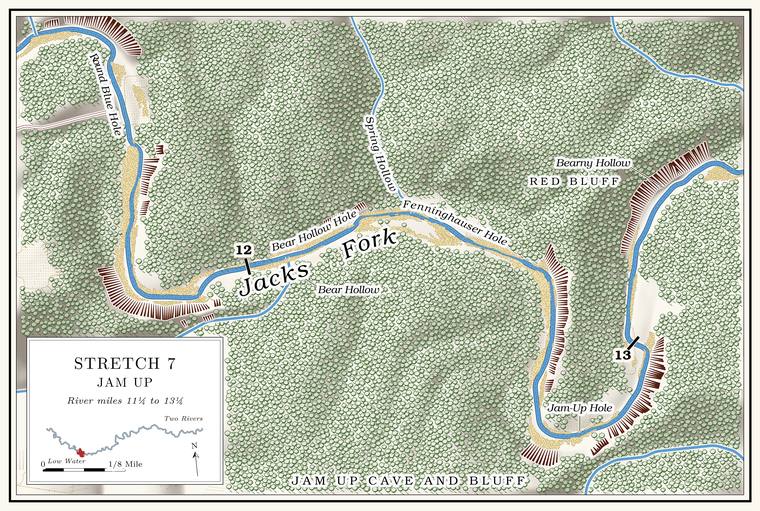
Round Blue Hole and the Holden Place
Pool and former farm · about mile 11.4 · Plate A5
The next Pool. A deep, slow stretch of river between riffles (Chapter 16). Glossary →, known as the Round Blue Hole, has a noisy spring at its upper end and a long Bluff. A cliff along the river, usually on the outside of a bend, where the river has cut sideways into the hill. In this sense the word was first used in North America (Chapter 2; Chapter 18). Glossary → on the left streaked with red. A farm on the right above it was known as the Holden Place, and the pool was reached through it.
The Jacks Fork Natural Area
Protected area · both banks · from about mile 11.5 for three miles
A little below Daveys Hollow the river enters the Jacks Fork Natural Area, 966 acresMDC, Jacks Fork Natural Area; see Reach C and Chapter 11. of Park Service land that the state added to its natural-area system on May 27, 1980, the same day as Barn Hollow upstream (Reach C; Chapter 11). Its upper end lies about four and a half river miles below the Highway 17 bridge and about two below Blue Spring, and it follows the river for about three miles. It takes in the Gravel bar. A bank of chert gravel and sand, usually on the inside of a bend, bare at low water (Chapter 15; Chapter 18). Glossary →, the Dolomite. Calcium magnesium carbonate rock, a close relative of limestone, formed from lime mud on the floor of a warm, shallow sea. Nearly every bluff on the Jacks Fork is dolomite (Chapter 1). Glossary → cliffs and Glade. An opening where bedrock lies at or near the surface and the soil is too thin and dry for trees, usually on a south-facing slope (Chapter 16). Glossary →, the bottomland and upland forest, dry Woodland. The period of prehistory from about 600 B.C. to A.D. 900 in radiocarbon years, when people here first made pottery and took up the bow (Chapter 3). Glossary → and caves, and more than 450 native plants have been recorded in it, along with Forty. Forty acres, a quarter of a quarter section. A hill farm was often one or two forties (Chapter 5). Glossary → native fishes and four kinds of crayfishMDC, Jacks Fork Natural Area; Dufur 2013, 20, 23; see Chapter 16. in the river (Chapter 16). The hills along this part of the river were logged like the rest of the country, but no logging Tram, tramway. A light logging railroad laid up a hollow, such as Cordz-Fisher’s line down Pine Hollow (Chapter 7). Glossary → reached them, and the timber went out by wagon to the mills at Birch TreeMDC, Jacks Fork Natural Area; see Chapter 7. (Chapter 7). In 1981 the Park Service studied about 4,000 acres around Jam Up Cave as a possible Wilderness. Federal land designated by law to be kept without roads or development. About 4,000 acres around Jam Up Cave were studied for it in 1981 and judged unsuitable (Chapter 10). Glossary → and judged it unsuitable (Chapter 10).
Near the head of the Natural area. A Missouri tract set aside as one of the best remaining examples of the state’s native communities, to be managed to keep it that way. The Jacks Fork and Barn Hollow natural areas were designated on May 27, 1980 (Chapter 11). Glossary →, where the river turns south, a natural arch stands on the left bank, hidden by trees from the waterDufur 2013, 20 (“the west-facing slope”); Johnson 2007, 26 (“the east bank”). Both describe river left of a south-flowing stretch.. Behind the arch is a rock courtyard with two smaller openings into it, an alcove and, at the back, a cave passage about 140 feet long set with small formations, some of them broken, its floor trodden with footprints. It is also called Three Entrance CaveJohnson 2007, 26.. Its exact position has not been fixedthe arch is not lettered on Plate A5..
Bear Hollow, Bear Hollow Hole and Bear Hollow Bluff
Hollow, pool and bluff · right bank · about mile 12.1 · Plate A5
Bear Hollow comes in from the south, draining about a square mile and a halfJacks Fork Creek Network 2026 (1.6 square miles).. The pool at its mouth, known as Bear Hollow Hole, lies under a high, flat, gray bluff on the right, by one account the largest bluff on the river to this point. A small spring seeps from the bank below the pool, and about a mile and a half to the north a large marshy basinLewis 1980, PDF p. 27, the only source. marks one of the many Sinkhole. A hollow in the ground where rock below has dissolved or caved in, through which water drains underground; also called a sink, an American use (Chapter 2; Chapter 12). Glossary → of the upland.
High in Bear Hollow Bluff, above the bend, is the big entrance of Black Bluff Cave, about 25 feet high and 30 wide and plain from the river. A muddy slope leads back to a thick stand of columns and Stalactite, stalagmite. A stalactite hangs from a cave ceiling, built from dripping water. A stalagmite builds up from the floor where the drip lands (Chapter 13). Glossary →, and the cave runs only about 120 feet in all. Little Black Bluff CaveJohnson 2007, 26. is on the same stretch. The name Black Bluff was kept for the cave out of deference to whoever first named the cave, though the bluff’s own name is Bear Hollow BluffMSS 1982, 13; see Chapter 13. (Chapter 13).
Fenninghauser Hole and Spring Hollow
Pool and hollow · left bank · about miles 12.1 to 12.3 · Plate A5
Fenninghauser Hole, just above the mouth of Spring HollowLewis 1980, PDF p. 29 (map: lettered along the run that ends where Spring Hollow comes in); Jacks Fork Oral History, record SV-23 (marked on a map at about mile 12.1); the mouth of Spring Hollow: USGS GNIS (726934), measured on the river centerline (12.26)., begins a big bend, with a high bluff on the left and a spring on the right below the pool. A longtime angler and hunter of the middle river, who spells it Fennenhauser, remembers the place for camping, picnics and fishingJacks Fork Oral History, record SV-23..
Spring Hollow, a small hollow of about a third of a square mileJacks Fork Creek Network 2026 (0.3 square miles)., comes in on the left. It is said to be named for a spring that rises through its floor, and the pool at its mouth took the same name. Two more springs come out above Jam Up Cave, the first of them cascading over the rocks, a fine sight early in the yearLewis 1980, PDF p. 27, the only source..
Jam Up Bluff and Jam Up Cave
Bluff and natural tunnel · right bank · about mile 12.8 · Plate A5
Jam Up Bluff, by one account the high point along the Jacks ForkNPS 1960, 19 (“the high point along Jacks Fork”), the only source. Taller faces stand above it, on the left at the Round Blue Hole (about 290 feet), and downstream; the tallest on the river, about 350 feet, is the face on the left bank across from Grandma Rocks (Reach G; Map 13)., climbs nearly to the rim of the upland on the outside of a sharp bend. In its face is the mouth of Jam Up Cave, an arch about 80 feet high and 100 feet wideMDC, Jacks Fork Natural Area; Dufur 2013, 21. at its base, half buried in fallen rockJohnson 2007, 26.. The bluff rises about 250 feet above the water just upstream of the cave mouth and about 210 feetthe right-bank faces at about miles 12.74 to 12.77 (tallest 12.76) and 12.84 to 12.98 (tallest 12.93), measured on the flood-mapping terrain (Heimann, Atkinson and High 2025; Map 13). The cave mouth and its slope of boulders probably lie in the break between the two faces, by the mouth of Jam Up Creek (12.80). just below it. Over a very long time slabs falling from the roof have enlarged the opening upward in rings, so that the arch has the shape of a bandshell, and its crown stands about 125 feet above the water, by one account close under the rimNPS 1960, 5, the only source. The faces beside the mouth measure about 210 and 250 feet (Map 13). of the canyon. The dark curve of the arch can be seen from far upstream. A slope of dolomite bouldersMDC, Jacks Fork Natural Area. falls from the entrance to the river, and the cave stream comes out on the left among the rocksJohnson 2007, 26–27.. A relatively fresh rockfall scar showed on the bluff face east of the cave in 2007Thornberry-Ehrlich 2016, 25 (fig. 19); see Chapter 1. (Chapter 1).
Strictly speaking Jam Up is a Natural tunnel. A cave open at both ends. Jam Up is a natural tunnel (Chapter 13; Reach E). Glossary →MDC, Jacks Fork Natural Area; see Chapter 13., a cave open at both ends (Chapter 13). Inside the arch a ridge of broken rock rises about 25 feet above the sloping floor, and behind it a hall runs back 350 to 400 feet among blocks the size of houses. Daylight reaches all the way in a dim, bluishJohnson 2007, 27. half-light. The hall ends at a deep pool in a pit where the roof of a lower level fell in, walled on three sides by cliffs about 20 feet high, and a waterfall pours into it from the cave’s upper level, carrying Jam Up Creek in from the far side of the ridge. On the far side of the ridge the upper level opens to daylight through a collapsed sinkhole about 60 feet across, a window through which the creek can be seen threading among fallen blocksNPS 1960, 4–5., and through a smaller skylightJohnson 2007, 28; MSS 1982, 35.. In floods the creek carries logs, sticks and leaves through the tunnel and jams them in the outlet, and the rubble ridge then acts as a partial dam; water has stood 15 to 20 feetNPS 1960, 5. deep behind it. Cavers who surveyed the whole system in October 1980 measured 1,749 feetMSS 1982, 36 (map). of passage.
An Eminence resident who has done park work remembers that a Section. A square mile of 640 acres, one thirty-sixth of a township. A quarter section is 160 acres (Chapter 5). Glossary → of the roof fell in, by that account in the late 1990sJacks Fork Oral History, record SV-12., and ceiling falls have happened in recent yearsNPS 2026 (Jam Up); see Chapter 13. (Chapter 13). A plan to raise mushrooms in the cave, about 1900, is said to have come to nothing, and a story is told of a horse that fell through the sinkholeLewis 1980, PDF pp. 27, 31, the only source. into the cave and lived. On September 1, 1940, Leslie Hubricht, a collector of snails, took a tiny spring snail of a kind that lives in springs and cave streams, along with a freshwater limpetField Museum of Natural History, Chicago, invertebrate collection, 283182 (Fontigens aldrichi, “Jam Up Cave”); University of Michigan Museum of Zoology, Ann Arbor, mollusk collection, 176189 (Ferrissia, “Jam Up Cave”)., from the cave; the specimens are in the Field Museum in Chicago and the University of Michigan’s Museum of Zoology.
Field work by the Missouri botanist B. F. Bush brought the plants around Jam Up Bluff to national attention long before the park. The magnesium-rich dolomite, caps of Roubidoux sandstone on the heights and slopes cut to face every direction pack a great many habitats into a small space, and by 1960 the list of plants found near the bluff and the cave included showy and small white lady’s-slippers, grass-of-Parnassus, American barberry, harebell and northern bedstraw, plants of the north mixed with plants of the Appalachians. They were taken then for a relic colonyNPS 1960, 19–20 (as Cypripedium reginae, C. candidum, Parnassia grandifolia, Berberis canadensis, Campanula rotundifolia, Galium boreale); see Chapter 16. left from the Ice Age (Chapter 16). Jam Up Bluff and Angel Ridge Bluff, a little downstream on the same side, are among the representative dolomite cliffs in the state’s classification of cliffsMDC, “Cliffs”; see Chapter 2. (Chapter 2).
Plants pressed at Jam Up are kept in herbaria as far apart as Columbia, St. Louis and San Diegothe specimens below.. Those collected in 1931 and 1932, in the University of Missouri’s herbarium, run from purple milkweed in the rocky woods and doll’s-eyes on the hillsides to bush clover on the glades, narrow-leaved bluets hanging from crevices in the bluff and leafy pondweed growing in the river itselfUniversity of Missouri Herbarium, Columbia, specimens 1616013 (August 13, 1931), 1681456, 1668062, 1634912, 1671893 and 1674505 (collector J. H. Kellogg; May 29 to September 4, 1932).. Julian Steyermark took autumn coralroot, a small leafless orchid, from the wooded ravine of Jam-up Hollow on November 30, 1935Missouri Botanical Garden Herbarium, St. Louis, specimen 3538101 (J. A. Steyermark, Corallorhiza odontorhiza, “Jam-up Hollow, 1 mi E of Jam-up”).. Bush, a storekeeper and botanist from Courtney in Jackson County, gathered hepatica on the rocky banks at Jam Up on April 17, 1936, when he was seventy-seven, ten months before his deathSan Diego Natural History Museum Herbarium, specimen SD00091314 (B. F. Bush 7050, Anemone americana, “Jam Up,” rocky banks; the label gives no county, and the place is taken to be this Jam Up); UNC Herbarium, “Benjamin Franklin Bush” (born December 21, 1858; storekeeper and postmaster at Courtney; died February 14, 1937), after Palmer 1937.. In November 1960 a moss specialist collecting around the cave and along Jam Up Creek took red-stemmed feathermossMissouri Botanical Garden Herbarium, specimen 90170667 (P. L. Redfearn Jr., Pleurozium schreberi, November 28, 1960, collected along Jam Up Creek and at Jam Up Cave and the bluffs along the river; also New York Botanical Garden, 624319, the same day)., a moss of the northern forests, and in May 1971 false bugbane, one of the plants on the 1960 list, was pressed on Jam Up BluffMissouri Botanical Garden Herbarium, specimen 3507791 (Arthur Christ, Trautvetteria caroliniensis, May 11, 1971, “Jam-up Bluff along Jack’s Fork of Current River”); on the 1960 list, NPS 1960, 19..
How Jam Up got its name, and the “Jimjam Cave”Dorrance 1938, 32; see Chapters 9 and 18. that a floater heard, probably in 1934, are in Chapters 18 and 9.
Jam-Up Hole and Jam Up Creek
Pool and creek mouth · right bank · about mile 12.8 · Plate A5
The pool below the cave, known as Jam-Up Hole, is full of large rocksLewis 1980, PDF p. 27, the only source, which calls the pool deep. and about 8 feet deep at Low Water. The local name for the Highway Y bridge over the South Prong, the access beside it and the county’s low-water crossing where the prongs meet, and so for the head of the river (Chapter 8; Chapter 18). Glossary →the pool’s depth below the riffle that holds it, measured on the 2021–23 riverbed survey (Heimann, Atkinson and High 2025; Map 12).. Jam Up Creek reaches the river on the right a short way below the portal, draining about 21 square miles. It heads in Mountain View and runs northeast toward the river, but below the town its water sinks into its bedsee Chapter 12. and travels underground to Big Spring on the Current River (Chapter 12). Above the tunnel it runs through a canyon of its own, and its largest Branch. A small creek. The sense is American, on record from 1674 (Chapter 18). Glossary → near the river, an unnamed hollow of about two and a half square miles, joins it from the west a little over half a mile above the mouthJacks Fork Creek Network 2026 (Jam Up Creek, 20.7 square miles)..
The narrow ridge between the creek and the river, the ridge that the tunnel pierces, is called the Devil’s BackboneJohnson 2007, 28., a name also given to the ridge between the river and Johnny Hollow on the right bank above RymersLewis 1980, PDF p. 30 (“above the river to the left of Johnny Hollow, by Rymer’s Ranch”) and the map on PDF p. 33 (“Devils Backbone” lettered south of the river, between it and Johnny Hollow, above Rymer’s Ranch).. Jam Up Creek probably once ran north toward the river on the far side of this ridge while the river cut south toward it from the other side. The creek’s bed broke through into a cave passage already dissolved in the rock, the creek followed the passage to the river, and its old valley below the break was left without a stream. That valley is taken to be Lost HollowNPS 1960, 4; MSS 1982, 34., which reaches the river two miles downstream (below). Piracy of this kind, through a cave, is very rareNPS 1960, 4 (“almost unique”); see Chapter 13. (Chapter 13).
A little downstream of the cave an immense gravel bar has built up on the inside of the bend, long used as a campJohnson 2007, 29; Dufur 2013, 21; see Chapter 20. (Chapter 20).