Pine Creek
Creek · right bank · South Prong mile 7.2 · Plates A1, A15
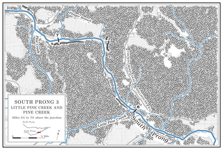
Pine Creek is the Prong. A branch or arm of a creek, set down in 1860 as Southern usage. The North and South Prongs join to form the Jacks Fork (Chapter 18). Glossary →’s largest tributary. It drains about 27 square miles, close to what the prong itself drains aboveMDC 2001, PDF 21 (Upper South Prong 30.9, Pine Creek 27.7). their meeting, and runs about twelve milesJacks Fork Creek Network 2026 (70.2 square kilometers, 19.3 kilometers). from its head near SterlingPottenger 1945, Howell file p. 84., a former Frisco station in the country north of Willow Springs named for John Sterling, an Illinois man who entered landPottenger 1945, Howell file p. 102. there. Joe FisherPottenger 1945, Howell file p. 36; see Chapter 5. ran a sawmill near Sterling in the early 1880s (Chapter 5). Esling Hollow, a valley whose name is unexplained, joins it from the south at the mouth of its largest side Branch. A small creek. The sense is American, on record from 1674 (Chapter 18). Glossary →, which drains nearly four square milesUSGS GNIS (Esling Hollow, mouth at 37.0550, −91.9092); Jacks Fork Creek Network 2026 (3.76 square miles).. The creek was named for its pines, which grew along the banks by one account and along the ridge by anotherO’Brien 1939, 103 (banks); Pottenger 1945, Howell file p. 84 (ridge); see Chapter 18. (Chapter 18).
The lowest eight miles of Pine Creek flow all yearMDC 2001, PDF 91 (class P, 8.0 miles); Lewis 1980, PDF 6 (“runs water all the time”).. The state scheduled the replacement of the 1932 Route 137 bridgeNational Bridge Inventory (structure 8748). over it for March to June 2026MoDOT 2026.. Near the mouth of Rebel Hollow, Rebel Road crosses it on a one-lane concrete slab of 1950National Bridge Inventory (structure 17965).. Around 1998 the Willow Springs landfillMDC 2001, PDF 94; see Chapter 17. held a state discharge permit on one of its branches (Chapter 17). Most of the small share of public land in the South Prong country is national forest in this drainageMDC 2001, PDF 67..
Oak Ridge School stood near Pine Creek. Between Pine Creek and the prong stood the Solid Rock Church, the Pleasant Grove Church and its cemetery, and Pine Creek SchoolLewis 1980, PDF 6, the only source for their positions., named for the creekO’Brien 1939, 103..
Spout Spring Hollow and Spout Spring. Spout Spring Hollow joins Pine Creek about four miles above its mouthUSGS GNIS (mouth at 37.0549, −91.8843), distance measured.. Its spring is on a hillside north of King’s Mountain, near Willow Springs. In the late 1930sPottenger’s fieldwork; her entries speak of 1937 (see Chapter 18). it was a good-sized spring that bubbled in a strong stream from the side of the hill, and its owner, Harrison Godsey, had piped the water up the hill to his house, so that it was sometimes called Godsey SpringPottenger 1945, Howell file pp. 41, 99 (“a good-sized spring bubbling in a strong stream from the side of a hill”; “put in pipes for carrying the water up the hill into his home”).. King’s Mountain is a high point on the divide with streams running off it in every directionPottenger 1945, Howell file p. 56 (“a high central point, or watershed from which streams run in every direction”).; its other sides drain to the Eleven PointPottenger 1945, Howell file p. 15; see Chapter 18. (Chapter 18). Maps of 1850 and 1855 call it King’s Mount. Some people held that a man named King lived there in the early days and others that the name came from the height alone, and a borrowing from the Revolutionary battle of King’s Mountain, in South CarolinaPottenger 1945, Howell file p. 56 (citing Missouri As It Was in 1867, 275, and two informants), the only source. Pottenger herself thought the name most probably came from the height., has also been suggested. About a mile east is a smaller rise, which by the late 1930s had been named Queen’s Mountain as its sisterPottenger 1945, Howell file p. 89 (“more recently given the name Queen’s as a sister mountain”).. In the 1930s the spring’s water was said to run through Spout Spring Hollow to the Jacks Fork in Shannon CountyPottenger 1945, Howell file p. 99 (“through Spout Spring Hollow into Jack’s Fork in Shannon County”).. On the map the hollow joins Pine Creek in Texas County, and the spring’s exact position has not been fixed.
Rebel Hollow comes into Pine Creek about a mile and a half above its mouthUSGS GNIS; National Bridge Inventory (structure 17965), distance measured., near the Rebel Road crossing. The name is said to date from the Civil WarLewis 1980, PDF 6 (“during the Civil War days”), the only source.; how it arose is not recorded. Pine Creek also takes in several sizable branches with no recorded nameJacks Fork Creek Network 2026..
Flinger Branch
Branch · left bank · South Prong mile 7.0 · Plates A1, A15
Flinger Branch, a branch of about a mile and a half from the northwest, enters almost opposite Pine Creek and drains nearly two square milesJacks Fork Creek Network 2026.. It is given both as a branch that runs water all the time and as one that may stop flowingLewis 1980, PDF 6 (“runs water all the time”); MDC 2001, PDF 90 (class C, 1.7 miles). in dry weather. The name is unexplained.
Little Pine Creek, Big Spring Creek and Big Spring
Creek and spring · right bank · South Prong mile 6.0 · Plates A1, A15
Little Pine Creek drains about ten square miles from the south, runs about six milesJacks Fork Creek Network 2026. and carries water all yearLewis 1980, PDF 6.. Its upper branches lie in northern Hutton Valley TownshipPottenger 1945, Howell file p. 8. in Howell County, and Big Spring Creek is the short run from Big Spring into it. The Township. A survey square of six miles on a side, holding thirty-six sections; also a division of a county, such as Jack’s Fork Township (Chapter 5). Glossary → took its name from the Hutton Valley post office, in a village laid out in 1873 and named for a Mr. Hutton, the first settler of that valley, who came about 1841Pottenger 1945, Howell file pp. 52–53 (Hutton Valley; Hutton Valley Township)..
In the late 1930s Howell County people gave the name Big Pine Creek to a stream in northern Hutton Valley Township that flowed into the Jacks Fork in Texas County, for the large pine timberPottenger 1945, Howell file p. 7 (“much large pine timber in that region”). of that region. They also called its branch, Big Spring Creek, Little Pine Creek, to tell it from the larger streamPottenger 1945, Howell file p. 8 (“to distinguish it from Big Pine Creek into which it empties”)., and Pine Creek was a separate streamPottenger 1945, Howell file p. 84. The identification of the old Big Pine Creek with today’s Little Pine Creek is an inference. again. On today’s map Big Spring Creek is a branch of Little Pine Creek and there is no Big Pine Creek. The likeliest reading is that the old Big Pine Creek is the present Little Pine Creek, and that “Little Pine” passed from the branch to the main stream early: the 1948 topographic map already letters the main stream Little Pine Creek in Texas County, shows no Big Pine Creek, and letters Big SpringUSGS 1948 (Clear Springs). a little south of the county line. A Mountain View resident calls Big Spring Creek “Pine Creek.” Moore’s Hollow, named for Hugh and Thomas Moore, brothers who lived there by 1867Pottenger 1945, Howell file p. 69., ran into the old Big Pine Creek and so probably lies somewhere in this drainage.
Big Spring gave the branch its name. It lies a little over the Howell County line, at the short runUSGS GNIS (Big Spring Creek, about 100 meters). of Big Spring CreekLewis 1980, PDF 6 (“just over the Howell County line”); USGS GNIS (Big Spring, Big Spring Creek).. In the late 1930s it was a spring of ordinary size that supplied good water to most of the communityPottenger 1945, Howell file p. 8 (“not unusually large, but it affords good water for most of the community”).. Measured before 1974 at 1.41MDC 2001, PDF 27; MDNR, “Springs” (Big Spring, Howell County, record 910001: 632.8 gallons a minute). cubic feet a second, it has also been put at about a million gallons a dayLewis 1980, PDF 6. (Chapter 12). It is no relation to the Big Spring on the Current River.
A small unnamed branch comes in from the north on the opposite bank about a quarter mile belowJacks Fork Creek Network 2026..
Dixon Ford
Former crossing · lower South Prong · Plate A15 (not marked)
Dixon Ford, also called Dixon Crossing, was a crossing on the lower prong, below Route 137. Who Dixon was has not been traced. A Mountain View resident remembered it as “a great place to hang out at the river,” with “a couple of good places to play in the water and get some sun,” and as a place where a float could start, until its new owners closed it to the public (Chapters 8, 11 and 20). It is private land.