Stillhouse Branch, Guild and Union Star
Branch, former post office and school · right bank · South Prong mile 5.0 · Plates A1, A15
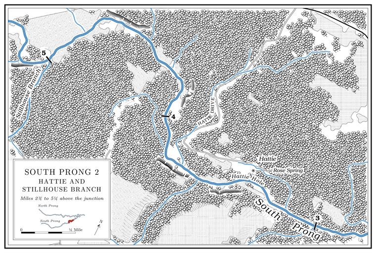
Stillhouse Branch comes in from the south, a little over two miles long and draining nearly three square milesJacks Fork Creek Network 2026.. It runs water, and it is said to have once had a whiskey-malting operationLewis 1980, PDF 6 (“runs water”; “once housed a whiskey malting operation”), the only source. on it. The watershed’s other Stillhouse. A building where whiskey was distilled. Several hollows on the river carry the name (Chapter 18; Reach F). Glossary → names are in Chapter 18.
Guild stood on the ridge west of the Branch. A small creek. The sense is American, on record from 1674 (Chapter 18). Glossary →, about half a mile south of the Prong. A branch or arm of a creek, set down in 1860 as Southern usage. The North and South Prongs join to form the Jacks Fork (Chapter 18). Glossary →USGS GNIS, Guild, after the USGS Clear Springs 15-minute quadrangle, 1945.. Its post office ran from June 1908 to March 1932, when its mail went to HattieLewis 1980, PDF 11; Rowe 2008 (Guild: Luke W. Parker, June 18, 1908; mail to Hattie); Forte, Postal History, Texas County (1908–1932).; it is also dated 1910 to 1928. In the late 1930s several people still remembered the office, and none of them could explain its nameO’Brien 1939, 55 (“several residents remembered the post office, but no one could offer an explanation for its name”).. Union Star School, also called Mount Olive, stood on the ridge above Stillhouse BranchLewis 1980, PDF 6., and the topographic maps of the 1940s show a Mount Olive School across the branch east of GuildUSGS GNIS, Guild, after the Clear Springs quadrangle of 1945; compare USGS 1948 (Clear Springs).. The school had been formed from two districts that kept both names, so on paper it was Star Union, and people called it Union Star because it sounded betterO’Brien 1939, 127 (“kept both names”; “usually called Union Star, as that name is more euphonious”).. Mount Olive was also the name of a Baptist churchO’Brien 1939, 88. of Pierce Township.
Hattie and Rose Spring
Former post office and spring · on the prong between Stillhouse Branch and Wolf Creek · position approximate · Plate A1
Hattie stood on the South Prong in the southeast part of Pierce Township, about a mile and a half northeast of GuildUSGS GNIS, Guild.. It was named for the wife of John CrossO’Brien 1939, 57., a landowner, and a John P. Cross kept its post office from 1902. The office opened on July 14, 1891, closed on July 2, 1894, reopened on March 29, 1898, and was discontinued on May 3, 1957, when its mail went to Mountain ViewRowe 2008 (Hattie: Shelby Bertram, July 14, 1891; discontinued July 2, 1894, mail “routed through Date”; re-established by Jacob L. Walker, March 29, 1898; discontinued May 3, 1957, mail “re-routed through Mountain View”). The office is also dated July 1891 to April 1957 (Lewis 1980, PDF 11), 1891/1957 (Forte, Postal History, Texas County) and 1893 to 1932 (O’Brien 1939, 57).. It stood near Rose SpringLewis 1980, PDF 11; his map (PDF 12) letters Hattie post office and Rose Spring on the South Prong; Rowe 2008 (John P. Cross, January 21, 1902)., a small spring on the farm of John RoseO’Brien 1939, 114 (“a small spring in Pierce Township”)., for whom the spring was named. The 1948 topographic map letters Hattie on the north bankUSGS 1948 (Clear Springs), section 24; USGS GNIS (Hattie)..
The man who knew the Hiker Hole (Chapter 15), who grew up on the upper river in the 1930s and has owned a farm on it since 1960Jacobson and Primm 1994, 40 (table 6)., described floodsJacobson and Primm 1994, 58. The link between the pool and the post office is an inference from the name. tearing out the timber at the lower ends of the big Hole. Any pool deep enough to swim or fish in, named or not, the basic unit of the river in local speech; also “hole of water” (Chapter 18). Glossary → and added: “Same thing with Hattie Hole. Hattie is gone—that’s on the South Prong.” The name very likely came from the settlement, since both were on the prong, but nobody recorded where the hole was. About here a small unnamed branch comes in from the southJacks Fork Creek Network 2026..