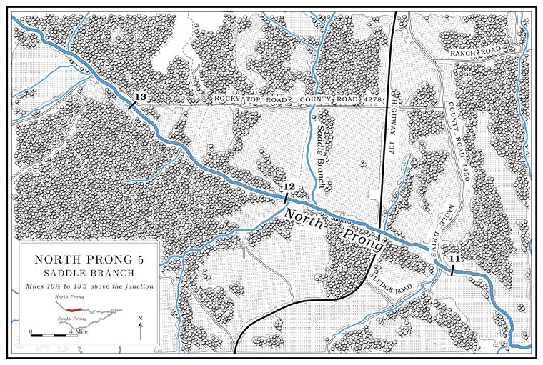
Saddle Branch
Branch · left bank · about North Prong mile 11.85
Saddle Branch comes down from the north, about two and three-quarter miles long and draining nearly three square miles. A few hundred yards upstream, at about mile 12.0, a creek of about the same size enters from the west on the opposite bank. It drains a little over three square milesUSGS GNIS; Jacks Fork Creek Network 2026. and has no name in any record, the largest such creek on the upper Prong. A branch or arm of a creek, set down in 1860 as Southern usage. The North and South Prongs join to form the Jacks Fork (Chapter 18). Glossary →. A saddle is a low gap in a ridge; which gap, if any, gave the Branch. A small creek. The sense is American, on record from 1674 (Chapter 18). Glossary → its name is not recorded.
Route 137 and the Nagle and Grogan neighborhoods
Highway crossing and former post offices · about North Prong mile 11.5 · positions estimated · Plates A1 and A14
Route 137 crosses the upper prong a little below Saddle Branch, about a mile above the mouth of Black Branch. The prong was dry here on August 14, 2006Mugel, Richards and Schumacher 2009, 19 (figure 9). (Chapter 12). While it was still a gravel road, into about the 1960s, its potholes were filled with gravel dug from the creeksJacobson and Primm 1994, 52 (“probably 25 years ago, 30 years ago,” counted from about 1993); see Chapter 15. (Chapter 15). A Mountain View resident who came to the area from Oklahoma in 1979 fished the North Prong by the highwayJacks Fork Oral History, record SV-05..
On the hill north of the bridge stood the Nagle church and school, lettered NogleUSGS 1948 (Clear Springs). on the 1948 topographic map, and a post office, the 86th in Texas County, opened in 1901, 1902 or 1904Lewis 1980, PDF p. 9 (from 1901); O’Brien 1939, 90 (1902); Forte, Postal History, Texas County (1904–1925).. Its postmasters ran from James M. Embree to William Lawson in 1922 and Mary Jane Lawson after him, and it closed in 1925. The office took its name from the C. H. Nagle family, landowners, as did a Methodist church and a school; it is also placed in Ozark TownshipO’Brien 1939, 90, the only source for the township; Forte, Postal History, Texas County, also closes the office in 1925., and the name Nagle still marks a place on the upland near hereUSGS GNIS (Nagle, 37.1667, −91.8193).. Joseph Nagle, a preacher, held services at the Nagle church and at the Rocky Ford churchLewis 1980, PDF p. 9. down the prong (see Tracy Hollow below).
The Grogan school and post office stood about three miles up the creek. The office ran from September 1897 to January 1954, when its mail went to Tyrone. Its name is traced both to its first postmaster, William B. GroganUSGS GNIS; USGS 1948 (Clear Springs). (also spelled Grogran)Lewis 1980, PDF p. 9 (Lewis spells it Grogran); Rowe 2008 (Grogan: William B. Grogan, September 16, 1897; mail to Tyrone); Forte, Postal History, Texas County (1897–1954)., and to J. E. Grogan, on whose land it was established; it is also dated from 1899 and placed in southeastern Cass TownshipO’Brien 1939, 55..