The 2006 station
Former stream station · about North Prong mile 2.7
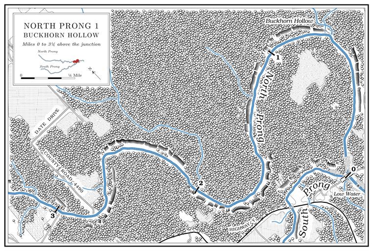
For part of the summer of 2006 the U.S. Geological Survey kept a station on the Prong. A branch or arm of a creek, set down in 1860 as Southern usage. The North and South Prongs join to form the Jacks Fork (Chapter 18). Glossary → between Tracy Hollow and Buckhorn Hollow, named “North Prong Jacks Fork below Arroll.” It recorded daily data from May 16 to July 20 and took three water samples. At that point, about 930 feet above sea level, the prong drains 55.9 square miles, nearly all of its basin. It has recorded nothing since. On the station’s last day, July 20, 2006, Survey biologists also took fish from the prong there, carmine and bleeding shiners, which went to the Mississippi Museum of Natural Science in JacksonMississippi Museum of Natural Science, Jackson, fish collection, catalog nos. MMNS 49231 (Luxilus zonatus) and 49232 (Notropis percobromus), “North Prong Jacks Fork, below Arroll,” July 20, 2006, collected by B. G. Justus and the staff of the U.S. Geological Survey’s National Water-Quality Assessment program, Ozark Plateaus study unit.. About seven-tenths of a mile below the station, at about mile 2.0Jacks Fork Creek Network 2026., a small Branch. A small creek. The sense is American, on record from 1674 (Chapter 18). Glossary → with no recorded name comes in from the north.
Buckhorn Hollow and Arroll
Hollow and village · left bank · North Prong mile 0.7 · Plate A1
Buckhorn Hollow comes down from the north-northwest and reaches the prong on its last loop, about seven-tenths of a mile above the junction, draining about 1.3 square milesUSGS GNIS; Jacks Fork Creek Network 2026.. The hollow leads north past the Arroll school to the villageLewis 1980, PDF p. 11..
The man who knew the Hiker Hole, who lived at the VFW camp below the Prongs in the early 1990s, counted at least two miles up each prong among the stretches where “all of those areas are filling upJacobson and Primm 1994, 57–58. and you’re getting Hole. Any pool deep enough to swim or fish in, named or not, the basic unit of the river in local speech; also “hole of water” (Chapter 18). Glossary → after hole after hole” (Chapter 15).
Arroll is a village on Route WLewis 1980, PDF p. 11 (“Highway W at Arroll”). in Date Township, on the upland about two miles north of the junctionmeasured from the federal names file’s point for Arroll (USGS GNIS).. The Township. A survey square of six miles on a side, holding thirty-six sections; also a division of a county, such as Jack’s Fork Township (Chapter 5). Glossary → was formed from Carroll Township in 1896 and was probably named for DateO’Brien 1939, 35 (her supposition)., a post office whose site is not known; Date’s first postmaster was appointed on June 20, 1892, and the office closed on February 1, 1896, when its mail went to OaksideRowe 2008 (Date: John H. Derks, June 20, 1892; discontinued February 1, 1896, mail “sent to Oak Side”); Lewis 1980, PDF p. 11 (1892 to 1896, mail to Oakside); Forte, Postal History, Texas County (1892–1896). O’Brien 1939, 35, dates the office from 1893.. Two stories explain Arroll’s own name. In one, the applicants proposed Carroll and “clipped off the C”O’Brien 1939, 5; see Chapter 5. when that name was taken (Chapter 5). In the other, Turner Cook sent in the name ARRALL, and his handwriting was read as ARROLLLewis 1980, PDF p. 11.. The first recorded appointment at the Arroll post office is dated July 9, 1898. The office closed on November 30, 1914, reopened on February 12, 1938, and closed for good on May 3, 1957, when its mail went to SummersvilleRowe 2008 (Arroll: W. M. Smotherman, July 9, 1898; re-established by William Conway, February 12, 1938). The office is also dated 1899–1914 and 1938–1957 (Forte, Postal History, Texas County), July 1898 to May 1957 (Lewis 1980, PDF p. 11) and 1900 to 1915, reestablished 1934 (O’Brien 1939, 5).. By one account the Jack’s Fork post office, kept by Reuben Harlow from 1849, became the Arroll office; that account dates the change to 1899Lewis 1980, PDF p. 11; Forte, Postal History, Texas County, ends the Jacks Fork office in 1899. Lewis 1980, PDF p. 11, also has the Arroll office in operation from July 1898., the year after the first Arroll appointment, and the Jack’s Fork office is also dated 1860 to 1902O’Brien 1939, 67; see Chapter 4. (Chapter 4).
In the early days William Harvell ran a hotel and livery stable at Arroll. In 1980 there were still a few homes, a church, a cemetery and a couple of storesLewis 1980, PDF p. 11.. A correspondent from Arroll sent the news to the Mountain View Standard in March 1913, including that “several men attended the bridge meeting at the Buck Hollow Ford” (Chapter 8). A Mountain View resident who grew up there in the 1960s and 1970s remembers that “it used to be a hopping place,” with “always someone at the store to chat with while grabbing a soda and a snack, maybe a little gas.” The same resident’s thoughts on what the park changed for people at the head of the river are in Chapter 11.
Collectors’ labels have long placed this country by its distance from Arroll. On April 27, 1952, Julian Steyermark, who later wrote the standard flora of the stateSteyermark 1963., collected spring coralroot, a small leafless orchid of shady woods, along the North Prong about two miles southwest of the villageField Museum of Natural History, Chicago, Botany Department herbarium, specimen V0413362F (J. A. Steyermark, Corallorhiza wisteriana, “2 mi. SW of Arroll, along North Prong of Jacks Fork”).. His labels of the 1930sUniversity of Missouri Herbarium, Columbia, specimens 1615102 and 1617905 (“Barn Hollow” canyon, “5 mi SE of Arroll,” August 17, 1934); see Reach C. give Barn Hollow and the Bluff. A cliff along the river, usually on the outside of a bend, where the river has cut sideways into the hill. In this sense the word was first used in North America (Chapter 2; Chapter 18). Glossary → of the river below the Prongs as so many miles southeast of Arroll (Reach C).
Below Buckhorn Hollow the North Prong finishes its loop and runs the last seven-tenths of a milemeasured along the prong centerline traced for the maps in this book. to meet the South Prong, which comes in from the west after passing under the Highway Y bridge. The county Low-water bridge, low-water crossing. A road crossing built low across a stream, a ford with a floor, often a concrete slab with culvert pipes beneath it, which water overtops in a rise (Chapter 8; Chapter 18). Glossary →see Chapter 8. near the junction is described in Chapter 8. The junction, where the river’s miles beginsee Reach C., and the two crossings at Low Water are in Reach C (Plate A3).
| Creek | Bank | North Prong mile | Drainage | Name |
|---|---|---|---|---|
| Harmon Branch | right | about 14.8 | 1.1 sq mi | federal map |
| unnamed | left | about 14.8 | 1.3 sq mi | none recorded |
| Peabody Branch | right | about 14.0 | 1.4 sq mi | federal map |
| unnamed | left | about 14.1 | 1.1 sq mi | none recorded |
| unnamed | right | about 12.0 | 3.2 sq mi | none recorded |
| Saddle Branch | left | about 11.85 | 2.9 sq mi | federal map |
| Black Branch | right | about 10.4 | 0.9 sq mi | federal map |
| unnamed | left | about 10.2 | 2.6 sq mi | none recorded |
| Peters Creek | left | 9.6 | 11.8 sq mi | federal map |
| Spargo Branch | right | about 8.2 | 3.2 sq mi | federal map |
| Sanders Branch | left | 7.8 | 3.5 sq mi | federal map |
| Harmon Hollow | left | 6.25 | 0.7 sq mi | federal map (valley) |
| unnamed | right | about 5.8 | 0.6 sq mi | none recorded |
| Pine Branch | left | 4.1 | 8.7 sq mi | federal map |
| Tracy Hollow | left | 3.7 | 1.1 sq mi | federal map (valley) |
| unnamed | left | about 2.0 | 0.7 sq mi | none recorded |
| Buckhorn Hollow | left | 0.7 | 1.3 sq mi | federal map (valley) |