Shawnee Creek
Creek · right bank · mile 43.5 · Plate A13
Shawnee Creek, also called Big Shawnee, comes in from the south at mile 43.5. It is the largest creek on the lower river, draining about twenty square miles, and runs about ten miles northMDC 2001, PDF 28–30 (table Ge03, 9.9 miles total, 8.5 permanent, fourth order); the creek network traces about 8.4 miles. to the river, all year in about its lower eight and a half. Its upper course comes down Black Valley and South HollowJacks Fork Creek Network 2026 (19.97 square miles, mouth at 43.48, right); USGS GNIS (Shawnee Creek, stream, mouth at 43.45).. Hay Hollow, its largest Branch. A small creek. The sense is American, on record from 1674 (Chapter 18). Glossary →, was in 1939 a valley “from which grass is cut for hay”Jacks Fork Creek Network 2026 (4.15 square miles); see Chapter 18. (Chapter 18).
The two Shawnee creeks carry the name of the Shawnee who were in this country early in the nineteenth centurysee Chapter 4. (Chapter 4). By one account a band of them lived on Shawnee Field, the Bottom. The flat land along a river or creek, built of its deposits and open to its floods. In the 1920s the bottoms near Eminence averaged about a quarter of a mile wide (Chapter 2; Chapter 5). Glossary → between the two creeks, and the creeks’ names are the only trace of their stay. By 1840 a Colonel Thomas Chilton farmed at the mouth of this one (Chapter 5), and Joseph Slater’s cabin and copper furnacesee Chapter 5. stood up the creek.
Up the creek, by one account, George N. DeatherageLewis 1980, PDF p. 79, the only source., known as Rumsey, ran a mill built by the millwright John C. McCaskill that was better known for its poker game and corn liquor than for the wheat and corn it ground. In the tie-cutting days there was a tie yard at its mouth. The story is told that after the war a farmer found the bones of two men killed on the creek, outlaws or Union soldiers. Nelson Chilton, Joshua Chilton’s son, is said to have escaped the Federals with a wounded arm in 1864Lewis 1980, PDF p. 79, the only source. The source calls his companion “his brother Joshus (son of Thomas Coot Chilton)”; “a kinsman” follows the parenthesis. Union patrols: see Chapter 6. and to have been killed later, with a kinsman, when they met a patrol on the road up Big ShawneeO’Brien 1939, 14; Lewis 1980, PDF pp. 74, 79. (Chapter 6).
At the mouth the park keeps the Shawnee Creek campground, a backcountry camp with a staging areasee Chapter 11. for riders (Chapter 11). Visitors there often meet the Shawnee Creek bandsee Chapter 11. of wild horses, which ranges along the lower river toward Two Rivers (Chapter 11). A water-quality station on the river above the creek’s mouth has been sampled since 1973MDC 2001, PDF 82; see Chapter 17. (Chapter 17).
Little Shawnee Creek and Fursman Spring
Creek, spring and mill sites · right bank · about miles 43.9 to 44.0 · Plate A13
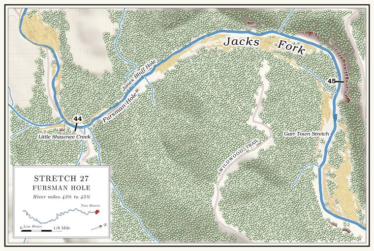
Little Shawnee Creek comes in from the south at about mile 43.9Jacks Fork Creek Network 2026 (9.35 square miles, mouth at 43.91, right); USGS GNIS (Little Shawnee Creek, mouth at 44.04)., less than half a mile belowthe river centerline (43.48 and 43.91). Shawnee Creek. It drains about nine and a half square miles down Slick Rock, Despain and Odell hollows and runs about six miles, all year in nearly fourMDC 2001, PDF 28–30 (table Ge03, 6.0 miles total, 3.8 permanent, third order); the creek network traces about 5.1 miles. miles of it. In 1939 it was said to be “named for the Indians who lived along the banks.” By one account Thomas DentLewis 1980, PDF pp. 74, 79, the only source., from North Carolina by way of Tennessee, moved to a farm near the mouth after the Civil War and built a small water-powered gristmill on the creek, and his son Hiram ran it until the early 1900s. A flour mill of Hiram Dent’s was on the creek in 1901. By 1980 no sign of it was left.
About three miles up are Betheny Chapel and its cemetery, the chapel named for Bethenia Hawkins Adair, the wife of Henry Lee Adair, who settled on the creek in the 1840s. The cemetery began as the Adair family’s burying ground and by 1980 held more than 250 graves. The Little Shawnee School stood about a mile and a half up the creek, and a post office called Shawnee served the creek from 1891 to 1918O’Brien 1939, 120; see Chapter 5. (Chapter 5). By one account John Chilton, taken by a Union patrol, was brought home to Little Shawnee, allowed to see his family and then shot.
On the right below the mouth of Little Shawnee, back from the riverUSGS GNIS (Fursman Spring, 718299, about 400 meters from the river at about mile 44.0, right)., Fursman Spring flows from under a small Bluff. A cliff along the river, usually on the outside of a bend, where the river has cut sideways into the hill. In this sense the word was first used in North America (Chapter 2; Chapter 18). Glossary → and runs into a small lake down its ravine. By one account the Fursmans lived there in the Depression. A map drawn from the federal surveyors’ notes of 1821 and 1840 shows a mill beside a spring near the mouth of Little ShawneeStevens 1991, 36 (“Central Shannon County Settlement Pattern 1840,” after Clendenen 1973)., probably the mill later called the Fursman Spring MillStevens 1991, 27, 34; see Chapter 5. (Chapter 5), and at one time a sawmill stood up the hollow from the spring. By one account Sam West built a new cabin near the spring in 1861. When riders came looking for him during the war, he hid under the bed and then fired on them, and they killed his father, John West, and mortally wounded his wife (Chapter 6).
Fursman Hole and the run north
Pool and bluff · right bank (bluff) · about miles 44.0 to 44.6 · Plate A13
Below Little Shawnee the river turns north for about two-thirds of a milethe river centerline (about miles 44.0 to 44.7).. Fursman Hole, about 5 feet deep at Low Water. The local name for the Highway Y bridge over the South Prong, the access beside it and the county’s low-water crossing where the prongs meet, and so for the head of the river (Chapter 8; Chapter 18). Glossary →the pool’s depth below the riffle that holds it, roughly its low-water depth, measured on the 2021–23 riverbed survey (Heimann, Atkinson and High 2025; Map 12; pool at about mile 44.09)., lies just below the creek mouth next to a bluff on the right that rises about 80 feetmeasured on the flood-mapping terrain (Heimann, Atkinson and High 2025; Map 13), the face on the right at about miles 44.11 to 44.18, the only face on either bank of the north run.. An unnamed hollow of about half a square mile comes in on the left at about mile 44.3Jacks Fork Creek Network 2026 (0.48 square miles, mouth at 44.28, left)..
The Garr Town Stretch
Stretch and spring · about miles 44.8 to 45.4 · Plate A13
At about mile 44.8 the river swings eastthe river centerline. along the Garr Town Stretch, also written Gar TownLewis 1980, PDF pp. 77 (map, “Garr Town Stretch”), 79 (“The Gar Town Stretch”); Plate A13., under a bluff on the left at about mile 45Plate A13. that rises about 160 feet, the tallest face on the river below Alleymeasured on the flood-mapping terrain (Heimann, Atkinson and High 2025; Map 13), the faces on the left at about miles 44.8 to 45.05; see Chapter 2.. The stretch is said to be named for the gar that once stayed along it in numbers, and a good spring comes out of a small hollow above it. The gar most likely here is the longnose, the most widespread gar in Missouri and the commonest gar of clear Ozark streams. It keeps to the larger, deeper Pool. A deep, slow stretch of river between riffles (Chapter 16). Glossary → and slow backwaters, often basks near the surface and commonly grows to about three feet, and from early May to mid-June it moves onto shallow gravelly Riffle. A fast, shallow, rocky stretch between pools. The riffles are the gardens of the riverbed: in July a square meter of riffle produced more than six times as much as a square meter of pool (Chapter 16). Glossary →MDC, “Longnose Gar.” The longnose is the only gar on the river’s fish list (see Chapter 16), so that the gar of the stretch were longnose is a likely inference. to spawn. By one account the wife of Doss Chilton, who lived on the ridge between the Current and the Jacks Fork, killed with a club a mountain lion her dogs had attacked, and killed a deer by rolling a large rock onto it from a bluff. The last known native mountain lion in Missouri was killed in the Bootheel in 1927MDC, Mountain Lions in Missouri..