Harlow Ford and Cold Springs
Former ford, springs and mill site · about mile 2.2 · Plate A3
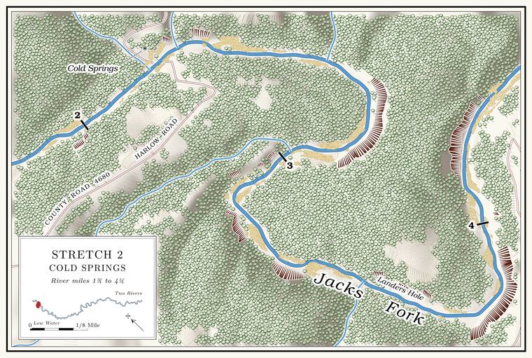
Harlow Ford crossed the river on a solid rock Bottom. The flat land along a river or creek, built of its deposits and open to its floods. In the 1920s the bottoms near Eminence averaged about a quarter of a mile wide (Chapter 2; Chapter 5). Glossary →Lewis 1980, PDF p. 14.. The 1948 topographic map letters a road crossing here as Harlow FordUSGS 1948 (Summersville); USGS GNIS., and a Mountain View native who now lives in Winona marked the Ford. A place where a road crosses through the water. Many of the river’s fords took the names of the families who lived beside them (Chapter 8). Glossary → on a map at the same placeJacks Fork Oral History, record SV-19 (marked on a map within a few yards of the federal names file’s point).. The old Cold Spring Road, a trail said to be older than settlementLewis 1980, PDF pp. 14, 16 (map), the only source; see Chapter 8., crossed at the ford (Chapter 8). In 1913 backers of a bridge at the Harlow Crossingsee Chapter 8. went to court against the county’s contract for one at Buck Hollow and lost, and Harlow stayed a ford (Chapter 8).
Greenberry Harlow, said to be a son of Reuben HarlowLewis 1980, PDF p. 9., one of the county’s earliest settlersO’Brien 1939, 57; see Chapter 5. (Chapter 5), is credited with a water-powered sawmill and gristmill at the ford after the Civil War. By one account the mill was rated at 12 horsepower and ran an upright saw, and in 1869 it sawed 100,000 feet of boards worth $1,000 and ground 600 bushels of cornmeal worth $300 and 6,000 pounds of flour worth $180. In 1879 it is said to have worked on a fall of four feet and ground 600 bushels of wheat and 8,000 of corn. Greenberry’s son SamLewis 1980, PDF p. 14, the only source; the figures appear to come from the federal censuses of manufactures, which have not been checked. ran it in later years. A Harlow’s Mill post office ran from February 1875 to February 1876, with Greenberry Harlow its only postmasterLewis 1980, PDF p. 14; Rowe 2008 (Harlow’s Mills: Greensberry Harlow, February 25, 1875; discontinued February 7, 1876); Forte, Postal History, Texas County (1875–1876).. He lived on a farm on the north side of the river below the Big BendLewis 1980, PDF pp. 14, 16 (map), the only source.. Sam Harlow’s granddaughter, the story goes, was the film actress Jean HarlowLewis 1980, PDF p. 14, the only source.. She was born Harlean Carpenter in Kansas City in 1911 and took her mother’s name, Jean Harlow, for the screen, and her mother’s father was a Samuel D. Harlow, a real-estate agent in Kansas City, KansasMcClure and Richardson 1999.; whether he was Greenberry’s son Sam has not been tracedno census or family record yet ties him to Greenberry Harlow’s household (The Open Ledger).. The Harlow School and the Harlow CemeteryLewis 1980, PDF pp. 14, 16 (map), the only source. are on the ridge to the south, where the Harlows and other local families are buried.
A small spring comes out on the right a little above the ford, from under a rock with a tree growing on top of it. Below the ford a Spring branch. The stream that runs from a spring to the river, such as the branch below Alley Spring (Reach H). Glossary → enters the first Pool. A deep, slow stretch of river between riffles (Chapter 16). Glossary →, Cold Springs Hole. A short way up the Branch. A small creek. The sense is American, on record from 1674 (Chapter 18). Glossary → the Cold Springs, two springs reputed to have been very cold, seep up through the valley floor, and the branch keeps a good flow up its narrow hollow to a source that comes out of the rocks. The springs are on the left bank. On the ridge beside the old road the Cold Springs Cemetery holds thirty or Forty. Forty acres, a quarter of a quarter section. A hill farm was often one or two forties (Chapter 5). Glossary → graves among old cedars, many of them marked with stones; the RoarkLewis 1980, PDF pp. 14, 16 (map). family is its main family, and the 1948 topographic map prints it as Cold Spring CemeteryUSGS 1948 (Summersville)..
Landers Hole and the Big Bend
Pools and bend · about miles 3.4 to 4.5 · Plate A3
Below Cold Springs Hole a spring-fed slough comes in, and the next long pool is Landers Hole. Then the river begins its longest bends. Between Harlow Ford and the mouth of Coon Hollow it runs nearly three miles to gain about a mile and a quartermeasured along the river centerline and in a straight line., and somewhere in these bends it crosses into the national riverways.
The pools of the bends carry old names whose places are not fixed. The crossing above Tune Hole was Tune Ford. The Big Bend held five big pools, from Tune Hole at its head to Rock-in-the-Hole at its foot, and four small springs on its south side, two of them beside a large patch of scouring rush. A Mountain View resident who grew up on this stretch had heard the names Big Bend and Tune HoleJacks Fork Oral History, record SV-20.. A big spring a fair distance up the hollow on the Big Bend is said to have been dammed in early times for a gristmillLewis 1980, PDF pp. 14, 16 (map), the only source..
The Stoops mill is said to have stood in this stretch, near the later VFW camp. By the same account it was a water-powered sawmill with an upright, hand-forged saw that cut lumber and ties and was working in the 1850s. It was put back to work in 1876 as a gristmill and sawmill and closed in 1880, when its millstones went upriver to another mill. It is credited to Joseph Stoops, a blacksmith, younger brother of Hugh Stoops, a circuit rider from PennsylvaniaLewis 1980, PDF pp. 14, 16 (map), the only source for these details. (Chapter 5).