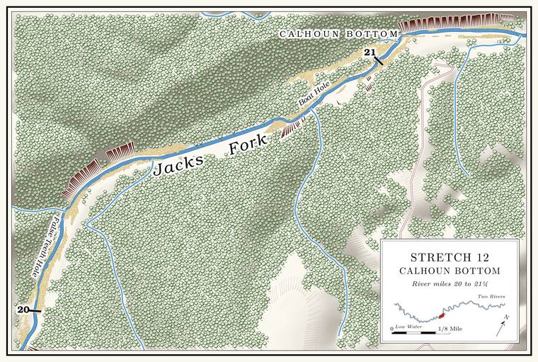
Eighteen Foot Hole and False Teeth Hole
Pools · about miles 20.0 to 20.2 · Plate A7 (False Teeth Hole)
Below Sycamore Hollow the river turns north into Eighteen Foot HoleLewis 1980, PDF p. 37 (map); Plate A7.. It is said to have its name from the giggers, whose sixteen-foot gig poleLewis 1980, PDF p. 34, the only source for the name’s origin. would not quite reach the Bottom. The flat land along a river or creek, built of its deposits and open to its floods. In the 1920s the bottoms near Eminence averaged about a quarter of a mile wide (Chapter 2; Chapter 5). Glossary →. Next is False Teeth Hole, which, the story goes, claimed a woman’s false teeth one day, and she was told to drag a roasting earLewis 1980, PDF p. 34, the only source. The scan prints “roasting car,” a misprint for roasting ear. of corn over the bottom to get them back.
Catfish Bluff and the Catfish holes
Bluffs and pools · both banks · about miles 20.5 to 20.9
The Upper and Lower Catfish Hole. Any pool deep enough to swim or fish in, named or not, the basic unit of the river in local speech; also “hole of water” (Chapter 18). Glossary → lie under Bluff. A cliff along the river, usually on the outside of a bend, where the river has cut sideways into the hill. In this sense the word was first used in North America (Chapter 2; Chapter 18). Glossary →, the upper on the left and the lower on the right, where the bluff rises about 150 feetmeasured on the flood-mapping terrain (Heimann, Atkinson and High 2025; Map 13), the face on the right at about mile 20.75, the only right-bank face within a quarter mile of the lower hole’s place, and so probably the 1980 map’s Lower Catfish Bluff.. The holes in the rock under the water are said to have made a good home for catfish, and small springsLewis 1980, PDF p. 34, the only source; the upper on the left and the lower on the right: Lewis 1980, PDF p. 37 (map). come in above and below the upper bluff. By the angler’s mark on a map, Catfish Bluff is on the left a little above Boat Hole.
Boat Hole, Calhoun Bottom and the Spring Hole
Pools and bottom · left bank (bottom) · about miles 20.8 to 21.2 · Plate A7
Boat Hole lies just above Calhoun Bottom, a field on the leftLewis 1980, PDF p. 37 (map); Plate A7., and below it comes the Spring HoleLewis 1980, PDF p. 34, the only source..